De Claar Stroom (Klaarstroom No. 178)
178 on the cadastre · on record 1777–1994 · show on the map
- Farm number
- No. 178
- On the cadastre
- 178, whole farmregistered as KLAARSTROOM
- District
- Prince Albert
- Extent, as the diagram states it
- 6498 morgen (loan farm plus annexed Government ground)
- Modern surveyed area
- 7257.1 ha
The historic extent and the modern surveyed area are two separate measurements and are not presented here as confirming each other. The first is what a surveyor wrote on a diagram, usually in morgen. The second is what the modern cadastre draws.
Why this farm is here
Petrus Oosthuizen (Klaarstroom, fl.1858-1860) held it. 3 km from Klaarstroom.
Petrus Oosthuizen (Klaarstroom, fl.1858-1860) is on record on this ground directly. No trace needed.
- story A written history is set on this ground De Claar Stroom: the farm the town stands on
- story A written history names this ground The men who drew the lines
- story A written history is set on this ground Twenty-four months
- parcel Ground cut out of this farm: De Claar Stroom No. 178 Ptn 1 (the arable)
- …and 2 more, listed in full further down this page.
Stories
- about this farm
De Claar Stroom: the farm the town stands on
The loan farm De Claar Stroom (Klaarstroom No. 178), granted 1777, is the ground Klaarstroom village stands on, not to be confused with Klaarstroom No. 184, which is Christian Hatting's grant 19 km west. Meiringspoort opened in 1858; twenty-seven erven were laid out on Petrus Oosthuizen's land and the village was called Petersburg for him. The erven were sold WITHOUT water rights. Who Petrus was is still unknown, and the one testable fact about him is a brother named Ockert.
- mentions this farm
The men who drew the lines
Every farm here passes through two officials: a veldkornet who knew the ground, and a surveyor paid by the sheet. Forty-two surveyor signatures over 172 years, a century of ward officers, and a ward boundary changing by hand on a 1934 diagram. The first surveyor, C. Lennox Stretch, was later dismissed for taking the Xhosa side.
- set here
Twenty-four months
Between February 1858 and February 1860 the Koup acquired a road to the sea, buried the couple the whole district descends from, laid out a village, had Crown land surveyed on its eastern edge, and met the industry that paid for the next forty years.
What the record holds, in order
- 1777–1860 boundary change same_as: from De Claar Stroom (the 1777 loan farm)
-
1777
event
De Claar Stroom loan farm granted
parent farm of Middelwater and Klaarstroom This is PAR-000097, Klaarstroom No. 178. The loan farm itself is PAR-000004.
-
August 1833
document
SG diagram 350/1833
P.A.Q. 5-8; earlier P.A. Q.3-30 of 18.8.1836
- 1858 boundary change subdivision: becomes De Claar Stroom No. 178 Ptn 1 (the arable)
-
1858–4 August 1860
event
Petrus Oosthuizen (Klaarstroom, fl.1858-1860)
Soon after Meiringspoort opened in 1858 the ground was surveyed and 27 erven measured out; the first sold on 4 August 1860. The loan farm ran from Middelwater to Vrolikheid. The ground was Petrus Oosthuizen's, and the village was called Petersburg for him; he and his BROTHER OCKERT enforced its stipulations. The erven were sold WITHOUT riparian rights - 'dry erven' - because the buyers meant to live off the traffic through the poort, not off the land. [TO VERIFY - local history] The ground is PAR-000097, Klaarstroom No. 178.
-
3 March 1858
event
Petrus Johannes Meiring (1799-1876) (30 November 1799–2 January 1876), Ger(H)olm Marincowitz (11 February 1805–13 May 1890)
[SRC-010, Rose Willis Klaarstroom cameo. TERTIARY, TO VERIFY] Twenty-two kilometres, twenty-five river crossings, built in 223 working days from 1856. Reconnoitred in 1854 by John Charles Molteno with Charles Pritchard, Andrew Geddes Bain and his son Thomas, who preferred Toorwaterpoort but conceded this route. Initial work by Thomas J Mellville, Sub-Inspector of Roads for George, with 93 hired labourers, later replaced by Adam de Smidt. Opened with 300 mounted men and 50 coaches riding from Klaarstroom through to De Rust; the champagne broke on the third attempt. The first 21 wool wagons went down almost immediately. This is the road that made Klaarstroom, and the town was surveyed within two years of it. The poort is why the town on PAR-000097 exists. | [1 Aug 2026, date audit] Two rows recorded the opening of the poort. EVT-000077 (1858, SRC-067) is retired into this one, which carries the exact date. ITS FACT IS KEPT: Zeekoegat prospered after the road opened, and with the 1891 gold it carried a hotel, bar, shop, butchery and post office. EVT-000077 is retired and its id is not reused.
-
1858 to 1860
ownership
Petrus Oosthuizen (Klaarstroom, fl.1858-1860)
quitrent · owner · confidence low
-
1860
event
Klaarstroom village laid out on Oosthuizen land
first named Petersburg The ground is PAR-000097, Klaarstroom No. 178.
-
1886
document
SG diagram B.19/1886
P.A.Q. 3-20 of 18.8.1886
- 1886 document SG diagram verso B.19/1886 (verso)
-
1 February 1901
event
Scheepers's commando rides into Klaarstroom
[SRC-010, Rose Willis Klaarstroom cameo. TERTIARY, TO VERIFY] Gideon Scheepers, Fouche and some 300 men, led in by Lieutenant FANIE SWANEPOEL, raided the post office and the government stores. Deneys Reitz was with them and describes it in Commando. Next day Lt-Col R.K. Parke of the 18th Imperial Yeomanry sent two patrols and five howitzers up the KREDOUW PASS from Prince Albert to drive them out. The village stands on PAR-000097.
-
1926
burial
John Edward Harding
Klaarstroom 178 farm cemetery
-
1926
burial
September Schoeman
Klaarstroom 178 farm cemetery
-
1927
burial
Maria Harding
Klaarstroom 178 farm cemetery
-
1939
burial
? Rabie
Klaarstroom 178 farm cemetery
-
1942
burial
P. A Stalmeester
Klaarstroom 178 farm cemetery
-
1944
burial
Rachel Macclune
Klaarstroom 178 farm cemetery
-
1948
burial
Rachel Schoeman
Klaarstroom 178 farm cemetery
-
1949
burial
Edward E Rabie
Klaarstroom 178 farm cemetery
-
1950
burial
Thomas Gorrah
Klaarstroom 178 farm cemetery
-
1950
burial
David Guwelaar
Klaarstroom 178 farm cemetery
-
1953
burial
Maria Guwelaar
Klaarstroom 178 farm cemetery
-
1954
burial
Andrina Minnie
Klaarstroom 178 farm cemetery
-
1957
burial
Lenie Rabie
Klaarstroom 178 farm cemetery
-
1960
burial
Stoffel H Benn
Klaarstroom 178 farm cemetery
-
1963
burial
H. C Macclune
Klaarstroom 178 farm cemetery
-
1964
burial
Goljat Kammies
Klaarstroom 178 farm cemetery
-
1965
burial
Johannes Jacobus Stalmeester
Klaarstroom 178 farm cemetery
-
1970
burial
Maria Rabie
Klaarstroom 178 farm cemetery
-
1975
burial
N Ruiters
Klaarstroom 178 farm cemetery
-
1978
burial
Sophie Stalmeester
Klaarstroom 178 farm cemetery
-
1981
burial
Maria Hendricks
Klaarstroom 178 farm cemetery
-
1988
burial
Arrie Wildschut
Klaarstroom 178 farm cemetery
-
1992
burial
Katriena Wildschut
Klaarstroom 178 farm cemetery
-
1994
burial
Appolis Daniel Katzen
Klaarstroom 178 farm cemetery
- undated document SG diagram verso 350/1833 (verso)
-
undated
burial
Anna Maria Bailey
Klaarstroom 178 farm cemetery
-
undated
burial
Jantjes
Klaarstroom 178 farm cemetery
-
undated
burial
Klaas Minnie
Klaarstroom 178 farm cemetery
-
undated
burial
Johannes Rabie
Klaarstroom 178 farm cemetery
-
undated
burial
Johannes Jacobus 195? Stalmeester
Klaarstroom 178 farm cemetery
-
undated
burial
Dina 197? Uksens
Klaarstroom 178 farm cemetery
Ground cut out of this farm
Buried on this ground
- Klaarstroom 178 farm cemetery 30 graves recorded
- Prince Albert district, Klaarstroom, Church of the Good Shepherd, church yard 0 graves recorded
The burials also appear on this farm's timeline above, each at its own date.
Also bordered by, as the modern cadastre draws it
Ground that touches this farm on the Surveyor-General's current polygons and that none of the diagrams held here names. Derived from the geometry, not read off a document.
- N Middelwater No. 169 Ptn 3
- N Rondabel No. 124 Remainder
- NE Rondabel
- NE Die Kruine No. 170
- E Vrolikheid
- E Wit Plaats (Vrolikheid No. 177 Ptn 1)
- E Oorlogs Kloof No. 172 (Roode Els Bosch and Oorlogs Kloof)
- SE Uitkyk Nek (Vrolikheid No. 177 Ptn 2)
- SE Faans Kraal (Vrolikheid No. 177 Ptn 4)
- SW Wilgemond No. 179
- W Avondrust (Middelwater No. 169 Ptn 6)
- W Moreson (Middelwater No. 169 Remainder)
- W Klein Valie No. 182
- W Groenkraal (Klein Valie No. 182 Ptn 7)
- NW Middelwater
- NW Ebeneser (Middelwater No. 169 Ptn 4)
Documents
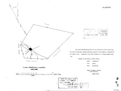 Surveyor-General diagram, 350/1833, August 1833
10259556 178 0.jpg
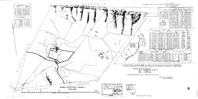 Surveyor-General diagram, B.19/1886, 1886
10UBJO01 178 0.jpg
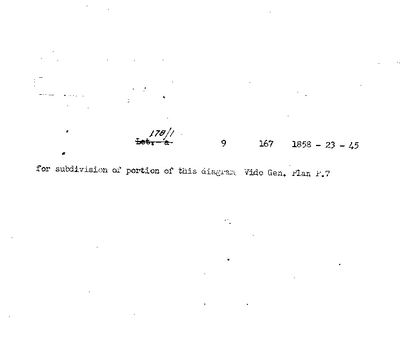 Diagram verso, 350/1833 (verso)
10259557 178 0.jpg
 Diagram verso, B.19/1886 (verso), 1886
10UBK601 178 0.jpg
Cadastre
Surveyor-General diagram index for this parcel
Research notes
THE GROUND THE TOWN STANDS ON, and the farm the diagrams mean when they write "Klaarstroom". Added Closes the known issue recorded in the repo conventions: Middelwater's EASTERN neighbour was written as "Klaarstroom" pointing at PLC-000003 - a PLACE id sitting in the neighbour_par_id column - because no parcel existed for it. On the 1883 diagram that neighbour is the farm, not the town.
NOT to be confused with PAR-000038, Klaarstroom No. 184 (Klaarstroom A), which we already held: 184 is 2,228 ha and sits about 19 km WEST of the town, while 178 is 7,259 ha and is the town's own ground. Two farms, one name, in one district - the 9 trap, and the reason the neighbour row could not simply be pointed at PAR-000038.
The cadastre carries 19 portions of 178; only the whole farm is held here. Klaarstroom was laid out on Petrus OosthuizenH's land and originally named PETERSBURG - see the Klaarstroom cameo material. [TO VERIFY] which portion, if any, corresponds to the original grant.
[31 Jul 2026] WRITTEN UP as STO-0014 after The loan farm DE CLAAR STROOM, granted 1777 (EVT-000001), is the ground Klaarstroom village stands on. Meiringspoort opened 3 Mar 1858 (EVT-000209); the town was then surveyed, 27 erven laid out, the first sold 4 Aug 1860, and it was called PETERSBURG for Petrus OosthuizenH (PER-000505), who owned the ground - with his brother OCKERT enforcing the town's stipulations (EVT-000206). THE ERVEN WERE SOLD WITHOUT RIPARIAN RIGHTS, 'dry erven', because the buyers meant to live off the traffic through the poort. Scheepers's commando rode in 1 Feb 1901 (EVT-000212).
ALL OF THAT IS SRC-010, a Karoo Cameo - TERTIARY. There is no grant document, no transfer, no deed reference and no diagram for farm 178 in this collection, which is the largest documentary gap in the district the project is anchored on.
[31 Jul 2026] RENAMED from 'Klaarstroom No. 178' to 'De Claar Stroom (Klaarstroom No. 178)' - "then maybe rename it to De Claar Stroom for consistency". A DELIBERATE DEPARTURE from what SCHEMA.md says current_name holds ('the name used today'), because today's name is the problem: the cadastre registers BOTH this farm and PAR-000038 as KLAARSTROOM, and on a map two polygons 19 km apart labelled 'Klaarstroom' is not a label, it is a trap. The loan farm's own name distinguishes them and is the name the written history uses. NOTHING IS LOST: the registered name and number stay in the parenthesis, the cadastre's own P_FARMNAME still reads KLAARSTROOM in the panel, and the farm number is unchanged. The map label takes the part before the bracket, so the polygon reads 'De Claar Stroom'.
[31 Jul 2026, audit] PAR-000004 'De Claar Stroom' ALREADY EXISTED when this row was created and I did not find it - I searched for 'Klaarstroom'. That row is the 1777 loan farm as a whole; this one is cadastral farm 178, the ground the village stands on, surveyed out of it. Linked as a subdivision. See the lead on whether the two should be one row.
[3 Aug 2026, SRC-223] ITS DIAGRAM, ITS EXTENT AND ITS TITLE. Dgm 350/1833, surveyed August 1833 by C. Lennox Stretch: the loan farm KLAARE STROOM with annexed Government ground, 6 498 morgen together, SURVEYED FOR THE WIDOW DU PRE, in the field cornetcy of C. Halling, Zwarte Berg. The title is P.A.Q. 5-8 dated 15 APRIL 1841 - the day STO-0007 is about - and an endorsement names P.H. DU PLESSIS & 2 OTHERS against the remainder - which SRC-225 dates to 18 August 1886, title P.A.Q. 3-20, not 1836 as I first read it. Bounded N by MIDDELWATER, S by VROLYKHEID, E by the TRAKA, W by WILGAMOUNT. The face draws the Klaarwater, a black square for the werf, and "9 Morgen of arable" - nine morgen of ploughland in six and a half thousand.
[3 Aug 2026, SRC-225] THE REMAINDER, RESURVEYED 1886. Dgm B.19/1886, framed by J.A. Thwaits under Act 9 of 1879: 3 413 morgen 140 square roods left of the original 6 498, titled P.A.Q. 3-20 on 18 August 1886 to P.H. DU PLESSIS & 2 OTHERS. Bounded N by Crownland, S by Welgemond and Vrolykheid, E by Vrolykheid, W by Middlewater, with Rondable beyond the crownland. Lot B on that sheet is 9 morgen 167 square roods - the arable, PAR-000151.
[3 Aug 2026, SRC-223 verso] Two township layouts are recorded against this farm, not one: General Plan F.7 on the back of the 1833 diagram ("for subdivision of portion of this diagram"), and General Plan K25 of 30 January 1901 on the back of Portion 1. Neither plan has been seen here. The verso also renumbers "Lot. a" to 178/1 and gives its deed as 1858-23-45 - the same 1858 transfer known from the front, which is what establishes that these deed references read YEAR-VOLUME-NUMBER.
*** [4 Aug 2026, FRANS, FAMILY] DIE TWEE DE CLAAR STROOM-RYE IS EEN PLAAS. *** [FAMILY] De claar stroom 178 and the other overlapping farm is the same. So PAR-000004, recorded here as the 1777 LOAN FARM, and PAR-000097, KLAARSTROOM No. 178, are the same ground under two epochs of record - the loan farm before survey, and the registered farm after it. They are not two farms and must not be counted, mapped or linked as two. WHAT WAS CHECKED BEFORE ACTING: no polygon in this model actually overlaps 178 except at the shared edges of its neighbours, so 'overlapping' means the two RECORDS overlap, not two shapes. PAR-000004 carries no farm number, no polygon and no centroid; PAR-000097 carries farm 178, its polygon and 7 259,5 ha. THE ROW IS KEPT, NOT DELETED - ids are permanent - and PAR-000004 stays as the record of the loan-farm epoch, which is where the 1777 date and the descent of Middelwater hang. It must never be pinned: there is only one piece of ground here and PAR-000097 is the one that carries it. This closes the De Claar Stroom third of LEAD-0080.
[SRC-316, 7 Aug 2026] A FARM CEMETERY IS RECORDED ON THIS GROUND BY eGGSA: 'Klaarstroom 178', Cemetery ID 6314, at -33.340383, 22.536633. Photographs and captions at https://graveswcape.eggsa.org/PRINCE-ALBERT-Rural/0518004%20WC%20PRINCE%20ALBERT%20distr%20Klaarstroom%20Plaasbegraafplaas_M%20Hammond/ - linked, not copied.
[8 Aug 2026, from SG 350/1833 read for the first time] THE FARM WAS HELD BEFORE THE GRANT, AND BY A WIDOW. Stretch surveyed it in August 1833 as 'the loan Farm Klaare Stroom including the annexed Government ground', 6498 morgen, 'Surveyed for THE WIDOW DU PRE' [PER-001602] - eight years before the 15 April 1841 title this project has treated as the farm's beginning. Nine morgen of it were arable, marked at the werf on the Klaarwater. The ward was the FIELD CORNETCY OF C. HALLING, ZWARTE BERG, which no other sheet here names. And TREKA is the eastern neighbour on this diagram - a place on the ground, not only the ward name LEAD-0014 turns on.
[8 Aug 2026] THE TWO EXTENTS ON THIS ROW ARE TWO DIFFERENT DATES, NOT A DISCREPANCY. extent_text says 6,498 morgen (5,565.7 ha) and sg_area_ha says 7,257.1 ha, 30% apart. Thwaits's 1886 resurvey (DOC-0191) gives the REMAINING PORTION as 8,413 morgen 140 roods = 7,206.2 ha, within 0.7% of the modern figure. So 6,498 morgen is the farm BEFORE the Act 9 of 1879 resurvey and the modern cadastral farm 178 is the Remainder that resurvey left. The farm took in about 1,932 morgen in the process, counting Lots A and B; Middelwater took in 1,888 morgen under the same Act, surveyor and examiner. Both figures are correct for their own moment.
[8 Aug 2026] The 1886 sheet's boundaries: North by Crownland, South by Welgemond & Vrolykheid, East by Vrolykheid, West by Middlewater - which agrees with Middelwater's own 1883 diagram naming Klaarstroom to its east. Title P.A.Q.3-20 of 18 August 1886.
The research behind this page, kept separate from it: dated working notes, open questions, and what is not yet settled.
Open questions
-
Order General Plan K25 (30 Jan 1901) - is it the layout of the village of Klaarstroom?
priority 1 · LEAD-0068
Does General Plan K25 lay out the village of Klaarstroom on the nine morgen of Portion 1, and if so who surveyed it, how many erven, and at whose instance?
What would settle it The plan itself. It will either show erven and streets, which settles it, or show a farm subdivision, which kills it. Either way it names the surveyor and the date, and an erf plan would name the applicant.
-
Why 15 April 1841? The project's headline question has never been a lead
priority 1 · LEAD-0091
Was the day a batch signature clearing a quitrent conversion backlog, a settlement scheme, or routine administration?
What would settle it The register. If many farms across the district share the date and the underlying entries are spread over years, it is a signing session and the question is answered.
-
Three farms carry the same name twice or three times, and ten story links are held back because of it
priority 2 · LEAD-0080
Which Rietfontein, which De Claar Stroom, and is Sleutelfontein (Groot and Klein) a real parcel or a composite of two?
What would settle it For each mention, which parcel the sentence means. For Sleutelfontein, whether PAR-000098 should exist at all given PAR-000071/072.
-
Lot A of Klaarstroom, 7 morgen 188 roods, is on the 1886 diagram and in no other record here
priority 2 · LEAD-0137
Thwaits's 1886 resurvey of Klaarstroom No. 178 (DOC-0191) tables two lots cut off the farm. Lot B, 9 morgen 167 square roods, is Barry's 1858 arable on the Groot River and is held as PAR-000151. LOT A, 7 morgen 188 square roods - given as a rectilinear 7 morgen 215 roods less 27 for the river boundary - is held nowhere. What is it, when was it cut off, and who took it?
What would settle it The 1886 verso's deduction table, or the diagram for the lot itself.
-
De Claar Stroom: one parcel or two?
priority 3 · LEAD-0039
PAR-000004 is the 1777 loan farm De Claar Stroom and PAR-000097 is cadastral farm 178, the ground Klaarstroom village stands on. Should they be one parcel row or two?
What would settle it The extent on the 178 title, compared with the loan farm's described run. If they are the same ground, one row; if 178 is a part, two.
What the record is missing
-
The record stops in 1860 and never resumes
second order · B2 trail-ends
De Claar Stroom (Klaarstroom No. 178) was worked as far as 1860, with Petrus OosthuizenH (Klaarstroom, fl.1858-1860) the last owner on record. 166 years follow with nothing. Who held it after that, and is it still one farm?
What would settle it The current title deed traced backwards, each transfer names the one before it, or the Surveyor-General's subdivision diagrams, which are what usually explain a farm going quiet.
Found by breaks.py reading the model against itself, not written by hand,
each one is a shape of missing record, not a fault in the data.
The whole set is on the
questions page.