Groot Sluitel Fontein No. 126
126 on the cadastre · on record 1860–1937 · show on the map
- Farm number
- No. 126
- On the cadastre
- 126, whole farmregistered as GROOT SLUITEL FONTEIN
- District
- Prince Albert
- Extent, as the diagram states it
- 48[?]0 morgen 300 square roods
- Modern surveyed area
- 4197.3 ha
The historic extent and the modern surveyed area are two separate measurements and are not presented here as confirming each other. The first is what a surveyor wrote on a diagram, usually in morgen. The second is what the modern cadastre draws.
Why this farm is here
Aletta Catharina Roux held it, a blood relative of the Oosthuizen, Marincowitz or Van der Merwe lines, 2 steps away. 18 km from Klaarstroom.
- Aletta Catharina Roux
- parent of Sophia Johanna Mocke
- parent of Frederik Simon Oosthuizen
Each step is a recorded parentage or marriage in this model, and the shortest one the record supports, follow the names to check it.
- story A written history names this ground Eighty-one thousand morgen
- parcel Ground cut out of this farm: Noorsdoringkop (Groot Sluitel Fontein No. 126 Ptn 1)
- border Shares a boundary with Rhemhoogte No. 125 Rhemhoogte No. 125
- border Shares a boundary with Noorsdoringkop (Groot Sluitel Fontein No. 126 Ptn 1) Noorsdoringkop (Groot Sluitel Fontein No. 126 Ptn 1)
- …and 2 more, listed in full further down this page.
Stories
- mentions this farm
Eighty-one thousand morgen
Frederik Simon 'Oom Frikkie' Oosthuizen died in 1936 holding, by one account, 81,000 morgen around Zwartkraal - about a quarter of all the ground on this map. This project holds not one deed in his name. What the money was probably in, what it was certainly not in, and the one document that would settle it.
What the record holds, in order
-
1860
document
SG diagram 1929/1860
P.A.Q.1-18
-
11 September 1862
ownership
Aletta Catharina Roux (1 February 1789–23 October 1868)
quitrent · grant · confidence high
- February 1937 boundary change subdivision: becomes Noorsdoringkop (Groot Sluitel Fontein No. 126 Ptn 1)
Ground cut out of this farm
- Noorsdoringkop (Groot Sluitel Fontein No. 126 Ptn 1) 1/126 · 1584.6 ha
Bordered by, as the diagram names them
- N Klein Sluitel fontein
- E Klein Sluitel fontein
- W Klein Sluitel fontein
- S Remhoogte
- SW Government ground
Also bordered by, as the modern cadastre draws it
Ground that touches this farm on the Surveyor-General's current polygons and that none of the diagrams held here names. Derived from the geometry, not read off a document.
- N Kleinbotterkraal (Klein Sleutlefontein No. 127 Ptn 1)
- NE Noorsdoringkop (Groot Sluitel Fontein No. 126 Ptn 1)
- E Swartskraal (Rhemhoogte No. 125 Ptn 5)
- SE Kareemoerhoek (Rhemhoogte No. 125 Ptn 4)
- S Reim Hoogte No. 167
- S Groot Sleutelfontein (Rhemhoogte No. 125 Ptn 2)
- SW Bloemendal Annex No. 164
- SW Tabaklande (Bloemendal Annex No. 164 Ptn 2)
Documents
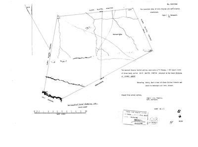 Surveyor-General diagram, 1929/1860, 1860
10107701.jpg
Cadastre
Surveyor-General diagram index for this parcel
Research notes
[30 Jul 2026 inbox] Crown land, 'Groot Sluitel Fontein', Gouph, division of Prince Albert; diagram 1929/1860 framed from actual survey by J.A. Thwaits, examined L. MarquardM. Extending north, east and west of Klein Sluitel fontein and south to Remhoogte and Government ground. Titled 11 Sep 1862, deed P.A.Q.1-18, in favour of J.A. Oosthuizen and another. [DIAGRAM] DOC-0135. EXTENT NOT FULLY READ: the typed figure is '48' + a damaged glyph + '0' morgen, 300 square roods. Using the modern surveyed area only to bound which digit it can be (NOT as corroboration of the extent - LEAD-0007), 4199.1 ha implies 4870-4890 morgen, so the glyph is 7, 8 or 9; 9 is closest. Left unread. [TO VERIFY]
[31 Jul 2026] Document ids corrected: the diagram rows for this farm were never created in July and the ids quoted here had since been reissued to unrelated TANAP inventories. Now DOC-0135.
[3 Aug 2026, SRC-068/SRC-212] NAMED IN F.S. OOSTHUIZEN'S HOLDING. Judy Maguire's account of Oom Frikkie's 81 000 morgen (SRC-068, and STO-0020) lists "Groot and Klein Sleutelfontein and Zeekoegat" among the farms he held. This project recorded that as a name-only row, PAR-000098, without anyone noticing that BOTH FARMS WERE ALREADY HERE, pinned and drawn - this one at 4 199,1 ha. The 1971 Rhemhoogte diagram (SRC-212) supplies the farm numbers that join the two records. WHAT THIS IS AND IS NOT: the cameo says he held them; this row says the farm exists and where it is. There is still no deed or ownership span in this model putting him on it - which is the whole point of STO-0020. [TO VERIFY]
[4 Aug 2026, FRANS, FAMILY] TWO DISTINCT FARMS, CONFIRMED, AND THE SPELLING IS THE ONLY THING THAT EVER VARIED: "Klein and Groot sleutel fonteint had various spellings over the years. sleutel, sluitel, etc but seems it was always 2 distinct farms - at least since surveyd." That closes the question this row's own note left open and matches the cadastre independently: two farm numbers (126 and 127), two drawn polygons, and the two touch. The spellings recorded here are Sleutelfontein, Sluitel Fontein, Sleutlefontein, Sleutle fontein and Sluitelfontein - kept as they were written, per 5a, and never normalised into one. AND AN ODDITY WORTH KNOWING BEFORE ANYONE REASONS FROM THE NAMES: KLEIN SLEUTELFONTEIN IS THE FAR BIGGER FARM - 16 916 morgen / 14 398,3 ha against Groot's ~4 870 morgen / 4 199,1 ha, a ratio of about 3,4 to 1. Both figures check against their own diagrams. The likeliest reading is that groot and klein name the SPRINGS rather than the farms, which is how these names usually work, but that is a reading and not established here.
[9 Aug 2026] THE ILLEGIBLE DIGIT STAYS ILLEGIBLE, BUT THE CADASTRE SAYS THE READING MAY BE WRONG ONE PLACE EARLIER. extent_text is '48[?]0 morgen 300 square roods' and sg_area_ha is 4,197.3. Every candidate for [?] falls short: 4890 morgen 300 roods is 4,188.9 ha, the closest, and still 0.20% under, with each digit step worth only 8.6 ha. 4900 MORGEN 300 ROODS IS 4,197.7 HA, which is 0.01% off. So the cadastre fits a figure whose SECOND digit is 9, not the 8 this transcription reads as certain. The bracket is on the third digit and the doubt may belong on the second. Not corrected: a cadastral area is not a reading of the sheet. [TO VERIFY] from the diagram itself.
The research behind this page, kept separate from it: dated working notes, open questions, and what is not yet settled.
Open questions
-
Three farms carry the same name twice or three times, and ten story links are held back because of it
priority 2 · LEAD-0080
Which Rietfontein, which De Claar Stroom, and is Sleutelfontein (Groot and Klein) a real parcel or a composite of two?
What would settle it For each mention, which parcel the sentence means. For Sleutelfontein, whether PAR-000098 should exist at all given PAR-000071/072.
What the record is missing
-
The record stops in 1862 and never resumes
second order · B2 trail-ends
Groot Sluitel Fontein No. 126 was worked as far as 1862-09-11, with Aletta Catharina RouxH the last owner on record. 164 years follow with nothing. Who held it after that, and is it still one farm?
What would settle it The current title deed traced backwards, each transfer names the one before it, or the Surveyor-General's subdivision diagrams, which are what usually explain a farm going quiet.
Found by breaks.py reading the model against itself, not written by hand,
each one is a shape of missing record, not a fault in the data.
The whole set is on the
questions page.