Part of De Claar Stroom (Klaarstroom No. 178)
De Claar Stroom No. 178 Ptn 1 (the arable)
· on record 1858 · show on the map
The farm's own history, the grant, the original survey, sits on that page.
- Farm number
- No. 178
- Portion
- 1
- District
- Prince Albert
- Extent, as the diagram states it
- 9 morgen 167 sq roods
This parcel has no matched survey polygon, so it cannot be drawn on the map. That is a gap in the cadastre match, not an absence from the record.
Why this farm is here
A piece of a farm already in this model. Not yet placed on the map.
- parcel Cut out of De Claar Stroom (Klaarstroom No. 178)
- document A document in the collection describes this ground DOC-0190
- document A document in the collection describes this ground DOC-0198
What the record holds, in order
- 1858 boundary change subdivision: from De Claar Stroom (Klaarstroom No. 178)
-
February 1858
document
SG diagram A.942/1858
Transfer 45 of 3.6.1858 (Vol. 23)
- undated document SG diagram verso A.942/1858 (verso)
Documents
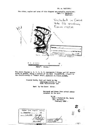 Surveyor-General diagram, A.942/1858, February 1858
11140329 178 1.jpg
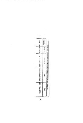 Diagram verso, A.942/1858 (verso)
11140330 178 1.jpg
Research notes
[3 Aug 2026, SRC-224] NINE MORGEN, AND THEY ARE THE NINE THAT MATTERED. The 1833 diagram of the whole farm (DOC-0189) marks a werf and writes "9 Morgen of arable" beside it. In February 1858 Frederick Wm. Barry surveyed exactly that off as Portion 1 - 9 morgen 167 square roods, bounded north, west and south by the rest of Klaarstroom and EAST BY THE GROOT RIVER - and it was transferred on its own deed, No. 45 of 3 June 1858. Out of 6 498 morgen, the first piece to be cut out and sold was the only piece that could be ploughed. The town of Klaarstroom stands on this farm (STO-0014). Absorbed into a 2014 consolidation, Farm 178/39, vide SG 1230/2014.
[3 Aug 2026, SRC-224 verso] AND THEN IT BECAME A TOWN. The back of this diagram has a printed deduction table that was never filled in - nothing was ever cut off Portion 1 and sold as land. Across it instead: "FOR SUBDIVISION OF PORTION K25 VIDE GENERAL PLAN K25", dated 30 January 1901. A general plan is the drawing made when ground is laid out into erven and streets rather than sold as veld. Klaarstroom the village stands on this farm, and on this evidence it stands on these nine morgen - the one piece that could be ploughed, cut off first in 1858, laid out into lots forty-three years later. Inference, not finding: the sheet names a general plan, not a village. General Plan K25 has not been seen. [TO VERIFY]
[13 Aug 2026] Renamed to the one form this model uses for every portion - the portion's own name, then the parent farm, its number and the portion in brackets - so that a name is legible in a list, a search result and a map popup without the reader having to know which farm number is which. It read "Klaarstroom Portion 1 (No. 178 Ptn 1) - the arable" before. Nothing about the ground changed.
The research behind this page, kept separate from it: dated working notes, open questions, and what is not yet settled.
Open questions
-
Order General Plan K25 (30 Jan 1901) - is it the layout of the village of Klaarstroom?
priority 1 · LEAD-0068
Does General Plan K25 lay out the village of Klaarstroom on the nine morgen of Portion 1, and if so who surveyed it, how many erven, and at whose instance?
What would settle it The plan itself. It will either show erven and streets, which settles it, or show a farm subdivision, which kills it. Either way it names the surveyor and the date, and an erf plan would name the applicant.
-
Lot A of Klaarstroom, 7 morgen 188 roods, is on the 1886 diagram and in no other record here
priority 2 · LEAD-0137
Thwaits's 1886 resurvey of Klaarstroom No. 178 (DOC-0191) tables two lots cut off the farm. Lot B, 9 morgen 167 square roods, is Barry's 1858 arable on the Groot River and is held as PAR-000151. LOT A, 7 morgen 188 square roods - given as a rectilinear 7 morgen 215 roods less 27 for the river boundary - is held nowhere. What is it, when was it cut off, and who took it?
What would settle it The 1886 verso's deduction table, or the diagram for the lot itself.
What the record is missing
-
Nobody is on record as ever having held this
third order · B8 never-held
De Claar Stroom No. 178 Ptn 1 (the arable) is in the model, and carries no ownership record of any kind, not a grant, not a transfer, not an occupation.
What would settle it The Surveyor-General's diagram for the farm number names the grantee and the date; the deed reference on it opens the transfer chain.
Found by breaks.py reading the model against itself, not written by hand,
each one is a shape of missing record, not a fault in the data.
The whole set is on the
questions page.