Reim Hoogte No. 167
167 on the cadastre · on record 1833–2020 · show on the map
- Farm number
- No. 167
- On the cadastre
- 167, whole farmregistered as REIM HOOGTE
- District
- Prince Albert
- Extent, as the diagram states it
- 3713 morgen
- Modern surveyed area
- 2784.8 ha
The historic extent and the modern surveyed area are two separate measurements and are not presented here as confirming each other. The first is what a surveyor wrote on a diagram, usually in morgen. The second is what the modern cadastre draws.
Why this farm is here
Willem Johannes Gous held it, and no kinship to the Oosthuizen, Marincowitz or Van der Merwe lines is recorded, this ground entered through the land, not the family. 12 km from Klaarstroom.
- story A written history names this ground The fifteenth of April, 1841
- story A written history names this ground The men who drew the lines
- story A written history is set on this ground The war reaches the Koup
- story A written history names this ground Eighty-one thousand morgen
- …and 2 more, listed in full further down this page.
Stories
- mentions this farm
The fifteenth of April, 1841
One surveyor works the Koup for two seasons. Eight years later, on a single day, the Crown turns a dozen loan farms into freehold - and the map of the district is set for a century.
- mentions this farm
The men who drew the lines
Every farm here passes through two officials: a veldkornet who knew the ground, and a surveyor paid by the sheet. Forty-two surveyor signatures over 172 years, a century of ward officers, and a ward boundary changing by hand on a 1934 diagram. The first surveyor, C. Lennox Stretch, was later dismissed for taking the Xhosa side.
- set here
The war reaches the Koup
The Anglo-Boer War came to these farms twice: up the road from Klaarstroom on 2 February 1901, when a running fight through Die Gang left a Boer of Scheepers's commando dead on Remhoogte; and quietly in 1903, when a woman from Tulbagh married into a Prince Albert family having buried two brothers in Natal thirty-four days apart - two brothers Deneys Reitz very probably names in Commando.
- mentions this farm
Eighty-one thousand morgen
Frederik Simon 'Oom Frikkie' Oosthuizen died in 1936 holding, by one account, 81,000 morgen around Zwartkraal - about a quarter of all the ground on this map. This project holds not one deed in his name. What the money was probably in, what it was certainly not in, and the one document that would settle it.
What the record holds, in order
-
August 1833
document
SG diagram 351/1833
BF.WQ 5-10
-
before 1833
ownership
Willem Johannes Gous
loan farm · survey · confidence high
-
15 April 1841
ownership
Willem Johannes Gous
Perpetual Quitrent · grant · confidence high
-
1863
burial
Hendrik Johannes Neethling (13 June 1795–31 May 1863)
Remhoogte 167 farm cemetery (first ground)
-
1865
burial
Martha Mary Ann Wilman
Remhoogte 167 farm cemetery (first ground)
-
February 1901
burial
Johannes Kleu (d. 1901, Remhoogte) (about 1878–February 1901)
Reim Hoogte 167 farm cemetery, Not read by this project; recorded from the eGGSA caption, which is a transcription made by somebody else.
- 1908 boundary change subdivision: becomes Rossel Erf (Reim Hoogte No. 167 Ptn 1)
-
1913
burial
Johanna Elizabeth du Plessis
Remhoogte 167 farm cemetery (first ground)
-
1913
burial
Johannes Gijsbertus du Plessis
Remhoogte 167 farm cemetery (first ground)
- 27 January 1922 document SG diagram verso 351/1833 (verso)
-
1926
burial
Ena du Plessis
Remhoogte 167 farm cemetery (first ground)
-
1941
burial
Jacobus Johannes Petrus du Plessis
Remhoogte 167 farm cemetery (first ground)
-
1945
burial
Susanna Frederika du Plessis
Remhoogte 167 farm cemetery (first ground)
-
1970
burial
Gertruida Alida du Plessis
Remhoogte 167 farm cemetery (first ground)
-
2012
burial
Marjorie Magdalena Koen
Remhoogte 167 farm cemetery (second ground)
-
2020
burial
Johan Matthys Koen
Remhoogte 167 farm cemetery (second ground)
-
undated
burial
Hannah Maria -186? Wilman
Remhoogte 167 farm cemetery (first ground)
Ground cut out of this farm
- Rossel Erf (Reim Hoogte No. 167 Ptn 1) 1/167 · 21.8 ha
Bordered by, as the diagram names them
- N Government ground
- S Venter's Klooff
- E Middle Water
- W Bloemendale
Buried on this ground
- Remhoogte 167 farm cemetery (first ground) 9 graves recorded, 1 identified in this project
- Remhoogte 167 farm cemetery (second ground) 2 graves recorded
- Reim Hoogte 167 farm cemetery 1 graves recorded, 1 identified in this project
The burials also appear on this farm's timeline above, each at its own date.
Also bordered by, as the modern cadastre draws it
Ground that touches this farm on the Surveyor-General's current polygons and that none of the diagrams held here names. Derived from the geometry, not read off a document.
- N Groot Sluitel Fontein No. 126
- N Groot Sleutelfontein (Rhemhoogte No. 125 Ptn 2)
- NE Rhemhoogte No. 125
- NE Kareemoerhoek (Rhemhoogte No. 125 Ptn 4)
- NE Swartskraal (Rhemhoogte No. 125 Ptn 5)
- E Middelwater No. 169 Ptn 3
- SE Middelwater No. 169 Ptn 1
- NW Bloemendal Annex No. 164
Documents
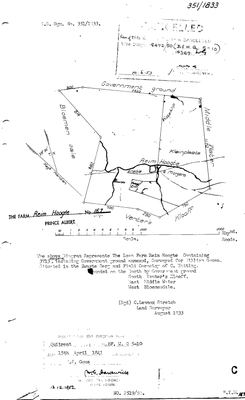 Surveyor-General diagram, 351/1833, August 1833
10TVJ301.TIF
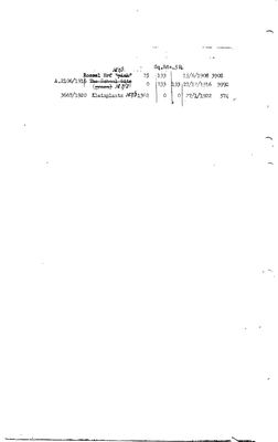 Diagram verso, 351/1833 (verso), 27 January 1922
10TVJ601.TIF
Cadastre
Surveyor-General diagram index for this parcel
Research notes
[31 Jul 2026 inbox] Bounded EAST BY MIDDLE WATER and south by Venter's Klooff (DOC-0126), so it sits west of Middelwater with Venters Kloof between them and the mountain. Loan farm surveyed Aug 1833 by Stretch for William Gouse, granted 15 Apr 1841 to WILLEM JOHANNES GOUS on quitrent BF.W.Q 5-10 - the folio the model had listed as belonging to 'an as-yet unplaced diagram'. It is this one. The 1833 face already shows Rossel Erf, a School Site, Kleinplaats and Witteklip.
[SRC-322, 7 Aug 2026] A FARM CEMETERY IS RECORDED ON THIS GROUND BY eGGSA: 'Reim Hoogte 167_1, Remhoogte', Cemetery ID 1359, at -33.282733, 22.414917. Photographs and captions at https://graveswcape.eggsa.org/PRINCE-ALBERT-Rural/0821015%20Remhoogte%20_2%20Prince%20Albert%20distrik_Pieter%20Olckers/ - linked, not copied.
[SRC-323, 7 Aug 2026] A FARM CEMETERY IS RECORDED ON THIS GROUND BY eGGSA: 'Reim Hoogte 167_2, Remhoogte', Cemetery ID 1359, at -33.281500, 22.411383. Photographs and captions at https://graveswcape.eggsa.org/PRINCE-ALBERT-Rural/Reimhoogte-167-2/ - linked, not copied.
[SRC-324, 7 Aug 2026] A FARM CEMETERY IS RECORDED ON THIS GROUND BY eGGSA: 'Reim Hoogte 167_3, Remhoogte', Cemetery ID 1359, at -33.281900, 22.410500. Photographs and captions at https://graveswcape.eggsa.org/PRINCE-ALBERT-Rural/0123008%20Prince%20Albert%20dist%20Remhoogte%20_Neels%20en%20neef/ - linked, not copied.
The research behind this page, kept separate from it: dated working notes, open questions, and what is not yet settled.
What the record is missing
-
The record stops in 1841 and never resumes
second order · B2 trail-ends
Reim Hoogte No. 167 was worked as far as 1841-04-15, with Willem Johannes GousH the last owner on record. 185 years follow with nothing. Who held it after that, and is it still one farm?
What would settle it The current title deed traced backwards, each transfer names the one before it, or the Surveyor-General's subdivision diagrams, which are what usually explain a farm going quiet.
Found by breaks.py reading the model against itself, not written by hand,
each one is a shape of missing record, not a fault in the data.
The whole set is on the
questions page.