Part of Rhemhoogte No. 125
Groot Sleutelfontein (Rhemhoogte No. 125 Ptn 2)
2/125 on the cadastre · on record 1883–1937 · show on the map
The farm's own history, the grant, the original survey, sits on that page.
- Farm number
- No. 125
- Portion
- 2
- On the cadastre
- 2/125, portionregistered as RHEMHOOGTE
- District
- Prince Albert
- Extent, as the diagram states it
- 2108 morgen 338 sq roods
- Modern surveyed area
- 381.1 ha
The historic extent and the modern surveyed area are two separate measurements and are not presented here as confirming each other. The first is what a surveyor wrote on a diagram, usually in morgen. The second is what the modern cadastre draws.
Why this farm is here
A piece of a farm already in this model. 16 km from Klaarstroom.
- parcel Cut out of Rhemhoogte No. 125
- parcel Cut out of Rhemhoogte No. 125 Ptn 1
- parcel Ground cut out of this farm: Kareemoerhoek (Rhemhoogte No. 125 Ptn 4)
- document A document in the collection describes this ground DOC-0174
- …and 1 more, listed in full further down this page.
What the record holds, in order
- 1883 boundary change subdivision: from Rhemhoogte No. 125 Ptn 1
-
July 1883
document
SG diagram 1350/1883
341/1884
- July 1883 document SG diagram verso 1350/1883 (verso)
- 1937 boundary change subdivision: becomes Kareemoerhoek (Rhemhoogte No. 125 Ptn 4)
Also bordered by, as the modern cadastre draws it
Ground that touches this farm on the Surveyor-General's current polygons and that none of the diagrams held here names. Derived from the geometry, not read off a document.
- N Groot Sluitel Fontein No. 126
- NE Noorsdoringkop (Groot Sluitel Fontein No. 126 Ptn 1)
- E Rhemhoogte No. 125
- E Kareemoerhoek (Rhemhoogte No. 125 Ptn 4)
- S Reim Hoogte No. 167
- W Bloemendal Annex No. 164
Documents
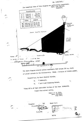 Surveyor-General diagram, 1350/1883, July 1883
10TSWK01 125 port 2.jpg
10TSWN01.jpg
Cadastre
Surveyor-General diagram index for this parcel
Surveyor-General diagram index for the whole farm — where the original survey of this ground sits.
Research notes
[3 Aug 2026, SRC-208] Cut out of Portion 1 (PAR-000139) in July 1883 and transferred on deed 341 of 25 January 1884 to J.P. Oosthuizen - the transfer PAR-000070 cites as its own antecedent. Surveyed by P. S. Dale. Its eastern neighbour is "Lot B", which is the ground that later becomes Kareemoerhoek (PAR-000070, Portion 4). [5 Aug 2026] THE EXTENT GAP IS EXPLAINED. This row's recorded extent of about 2,108 morgen stood against a modern polygon of 381 ha - 4.7 times over, and the largest unexplained discrepancy in the model. Portion 2's own deduction table (DOC-0243) carries one line: diagram 4241/1937, KAREEMOERHOEK, 1654,0080 morgen, deed 13528/1937. Take that off and 454 morgen remain, about 389 ha, which is the polygon to within 2%. The ground became Portion 4 (PAR-000070).
[13 Aug 2026, SRC-436] NAMED FROM THE 2023 VALUATION ROLL, which gives this portion as "Groot Sleutelfontein" (389.3411 ha). This row previously read "Lot A (Rhemhoogte No. 125 Ptn 2)", which was a farm-and-portion label rather than a name. The roll is a rates document and good evidence for what the ground is called now; it says nothing about what it was called when the portion was cut. AND THE ROLL CONFIRMS THE 5 AUG DEDUCTION-TABLE READING RATHER THAN CONTRADICTING IT. This row's 1883 extent is 1805.6 ha; the roll gives Kareemoershoek (portion 4) as 1416.7 ha, which is the 1654.0080 morgen the deduction table says was cut off this portion in 1937 to within a hectare; and 1805.6 minus 1416.7 is 388.9 against the roll's 389.3 ha for portion 2. So the two extents are not in conflict at all: ours is the portion as first cut, the roll's is what is left of it, and the difference is Kareemoerhoek.
The research behind this page, kept separate from it: dated working notes, open questions, and what is not yet settled.
Open questions
-
Six parcels whose surveyed extent is far from their polygon with no reason recorded
priority 2 · LEAD-0093
For each, is the extent mistyped, or did ground leave the farm without a note?
What would settle it The deduction table. It lists portion, name, extent, diagram and deed on one line.
-
Nine diagram sheets named in the model that no longer exist on disk
priority 2 · LEAD-0095
Re-pull nine Surveyor-General sheets whose archive references this model records but whose images were never kept. What do their versos carry?
What would settle it Re-pulling the nine files. Each then gets its OWN DOC- row per 8, never a second filename on an existing row.
What the record is missing
-
Nobody is on record as ever having held this
third order · B8 never-held
Groot Sleutelfontein (Rhemhoogte No. 125 Ptn 2) is in the model and drawn on the map, and carries no ownership record of any kind, not a grant, not a transfer, not an occupation.
What would settle it The Surveyor-General's diagram for the farm number names the grantee and the date; the deed reference on it opens the transfer chain.
Found by breaks.py reading the model against itself, not written by hand,
each one is a shape of missing record, not a fault in the data.
The whole set is on the
questions page.