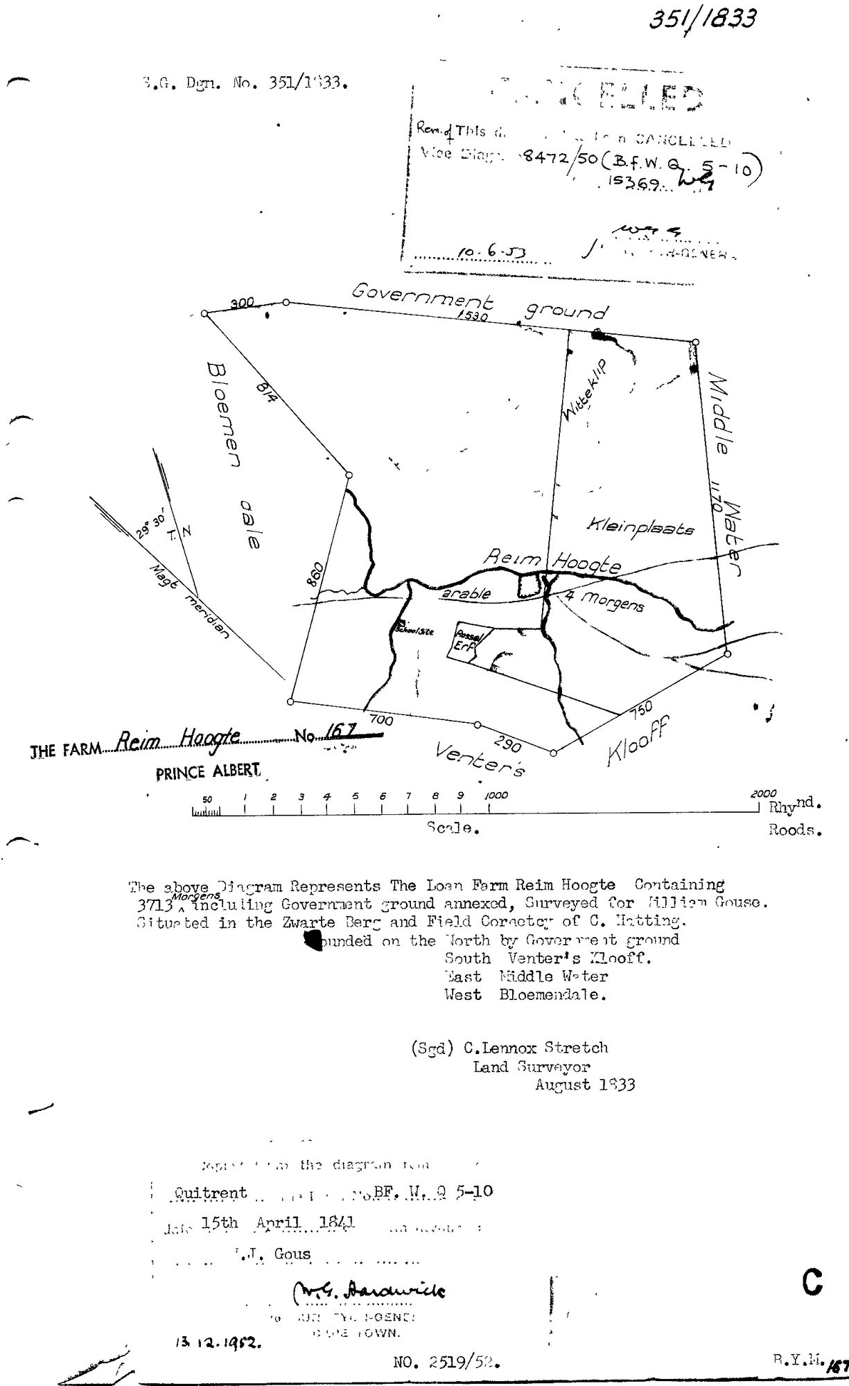
Surveyor-General diagram, 351/1833, August 1833
Surveyor-General diagram, August 1833
10TVJ301.TIF.The record
- Type
- Surveyor-General diagram
- Diagram number
- 351/1833
- Surveyed
- August 1833
- Titled
- 15 April 1841
- Deed
- BF.WQ 5-10
- Surveyor
- C. Lennox Stretch
- Archive filename
- 10TVJ301.TIF
Citation
- Title
- Reim Hoogte No.167 diagram (cancelled)
- Repository
- Surveyor-General
- Reference
- SG Dgm 351/1833 (vice 8472/50)
- Type
- SG diagram
The ground it is about
Research notes
"The Farm Reim Hoogte No. 167, Prince Albert." Surveyed August 1833 by C. Lennox Stretch for William/Willem Gous (quitrent registered to F.J. Gous), 3713 morgen including annexed Government ground, Field Cornetcy of C. HattingM. Bounded North by Government ground, South by Venter's Klooff, East by Middle Water, West by Bloemendale. Quitrent B.F.W.Q.5-10 dated 15 April 1841. Stamped CANCELLED, vice Diagram 8472/50 (10.6.53). NOT ONE OF THE FIVE CORE FARMS - logged because it is Middelwater's (PAR-000001) own N/W neighbour on the ground (matches the existing unlinked 'Remhoogte' rows in neighbours.csv) and directly corroborates that boundary from the neighbour's own diagram. See companion deductions table DOC-0071. No parcel record created for this farm; per §9a this stays boundary evidence for Middelwater, not a sixth tracked farm.
[31 Jul 2026, audit] par_id SET to PAR-000092. It was blank, so 5-10 kept reading as 'an as-yet unplaced farm' in the 1841 story and the document sat in the loose-evidence break list - while this row's OWN transcription has said 'The Farm Reim Hoogte No. 167' all along. SAME DIAGRAM AS DOC-0126: both are archive file 10TVJ301, this one the TIF and that one a clearer JPG filed from the inbox on 31 Jul. Two scans of one sheet, both kept - the project keeps the original filename and a clearer copy is evidence, not clutter.
[5 Aug 2026] MERGED DOC-0126 INTO THIS ROW - one sheet, two rows. The model already said so: DOC-0126's own note read 'SAME DIAGRAM AS DOC-0070 - both are archive file 10TVJ301, that one the TIF and this the clearer JPG. Not a second sheet.' The DOC-0019 standard (known_issues.txt, 5 Aug) is one row per sheet with source_file pointed at the clearer copy. DOC-0126 is retired and its id will never be reused. DISAGREEMENTS between the two rows, recorded rather than resolved: original_filename: kept '10TVJ301.TIF', DOC-0126 said '10TVJ301.jpg'; source_file: kept 'sources/diagrams/DOC-0070-reimhoogte-no167-1833.tif', DOC-0126 said 'sources/diagrams/DOC-0126-reim-hoogte-no167-1833.jpg'; deed_ref: kept 'BF.WQ 5-10', DOC-0126 said 'BF.W.Q 5-10'; source_id: kept 'SRC-106', DOC-0126 said 'SRC-156'; image_edtf: kept '1833', DOC-0126 said '1952'. DOC-0126's own note read: [31 Jul 2026 inbox] The unplaced 5-10 is placed: Reim Hoogte No. 167, W.J. Gous.
[31 Jul 2026, audit] SAME DIAGRAM AS DOC-0070 - both are archive file 10TVJ301, that one the TIF and this the clearer JPG. Not a second sheet. DOC-0070's transcription already identified Reim Hoogte; its par_id was simply blank, which is now fixed.
[5 Aug 2026] source_file repointed at the JPG, which is 859 kB against the TIF's 25 kB - effectively a thumbnail, the same problem DOC-0019 had. The TIF stays on disk as the archive master and is an accepted orphan, recorded in known_issues.txt. The file was renamed off the retired id DOC-0126 onto this row's own, the same treatment DOC-0138 got when the 31 Jul id-collision was repaired. Nothing is lost by it: 12 protects the ARCHIVE filename, which is 10TVJ301.TIF and lives in original_filename where it always has.
The research behind this page, kept separate from it: dated working notes, open questions, and what is not yet settled.