Part of Groot Sluitel Fontein No. 126
Noorsdoringkop (Groot Sluitel Fontein No. 126 Ptn 1)
1/126 on the cadastre · on record 1937 · show on the map
The farm's own history, the grant, the original survey, sits on that page.
- Farm number
- No. 126
- Portion
- 1
- Also recorded as
- NoorsdoringkopDIAGRAM, SG dgm approved 13 Jul 1937, DOC-0136Klein SleutelfonteinSRC-436, 2023 valuation roll
- On the cadastre
- 1/126, portionregistered as GROOT SLUITEL FONTEIN
- District
- Prince Albert
- Extent, as the diagram states it
- 1849.4483 morgen
- Modern surveyed area
- 1584.6 ha
The historic extent and the modern surveyed area are two separate measurements and are not presented here as confirming each other. The first is what a surveyor wrote on a diagram, usually in morgen. The second is what the modern cadastre draws.
Why this farm is here
Anna Margaretha Oosthuizen held it. 18 km from Klaarstroom.
Anna Margaretha Oosthuizen is on record on this ground directly. No trace needed.
- story A written history is set on this ground Three farms in one deed: Anna Margaretha, 1937
- parcel Cut out of Groot Sluitel Fontein No. 126
- border Shares a boundary with Rhemhoogte No. 125 Rhemhoogte No. 125
- border Shares a boundary with Kareemoerhoek (Rhemhoogte No. 125 Ptn 4) Kareemoerhoek (Rhemhoogte No. 125 Ptn 4)
- …and 2 more, listed in full further down this page.
Stories
- about this farm
Three farms in one deed: Anna Margaretha, 1937
On 20 December 1937 one transfer deed put three farms and 11,897 morgen into the name of Anna Margaretha Marincowitz, born Oosthuizen - Tokkie's mother, and one of only seven women in this model recorded holding ground in her own right. Her father had died fourteen months earlier and her brother took the neighbouring portion the same day.
What the record holds, in order
- February 1937 boundary change subdivision: from Groot Sluitel Fontein No. 126
-
February 1937
document
SG diagram (illegible)
T13528/1937
-
20 December 1937
ownership
Anna Margaretha Oosthuizen (5 October 1879–3 December 1973)
freehold · transfer · confidence high
Bordered by, as the diagram names them
- N Kleinbotterkraal
- E Remainder of Portion of Rhemhoogte
- SE Kareemoerhoek
- SW Remainder of Lot A
- W Remainder of Groot Sluitel Fontein
Also bordered by, as the modern cadastre draws it
Ground that touches this farm on the Surveyor-General's current polygons and that none of the diagrams held here names. Derived from the geometry, not read off a document.
- E Swartskraal (Rhemhoogte No. 125 Ptn 5)
- SW Groot Sleutelfontein (Rhemhoogte No. 125 Ptn 2)
- W Klein Sleutlefontein No. 127
Documents
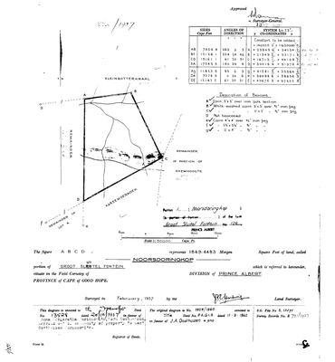 Surveyor-General diagram, (illegible), February 1937
SCAN341.jpg
Cadastre
Surveyor-General diagram index for this parcel
Surveyor-General diagram index for the whole farm — where the original survey of this ground sits.
Research notes
[30 Jul 2026 inbox] Figure ABCD, 1849.4483 morgen, called NOORSDORINGKOP, portion of Groot Sluitel Fontein, division of Prince Albert. Surveyed February 1937 by J.H.E. Hartwig; approved 13 Jul 1937; coordinates on System Lo.23. Neighbours as drawn: Kleinbotterkraal N, Remainder of Portion of Rhemhoogte E, Kareemoerhoek SE, Remainder of Lot A SW, Remainder W. [DIAGRAM] DOC-0136. The 1937 extent and the modern cadastre portion agree to 0.07% (1849.4483 mg = 1584.1 ha vs 1/126 = 1585.3 ha), which is what identifies this parcel as CSG 1/126 independently of the name.
[31 Jul 2026] Document ids corrected: the diagram rows for this farm were never created in July and the ids quoted here had since been reissued to unrelated TANAP inventories. Now DOC-0136.
[13 Aug 2026] Renamed to the one form this model uses for every portion - the portion's own name, then the parent farm, its number and the portion in brackets - so that a name is legible in a list, a search result and a map popup without the reader having to know which farm number is which. It read "Noorsdoringkop (Groot Sluitel Fontein Ptn 1)" before. Nothing about the ground changed.
The research behind this page, kept separate from it: dated working notes, open questions, and what is not yet settled.
Open questions
-
Anna Margaretha Oosthuizen assembles three farms in one deed, 1937
priority 2 · LEAD-0040
On 20 December 1937 one transfer deed put Noorsdoringkop, Kleinbotterkraal and Kareemoerhoek into the name of Anna Margaretha Marincowitz, born Oosthuizen - over 10,240 morgen. Who assembled it, and with whose money?
What would settle it The deed itself: it names consideration and predecessor in title.
-
Three farms carry the same name twice or three times, and ten story links are held back because of it
priority 2 · LEAD-0080
Which Rietfontein, which De Claar Stroom, and is Sleutelfontein (Groot and Klein) a real parcel or a composite of two?
What would settle it For each mention, which parcel the sentence means. For Sleutelfontein, whether PAR-000098 should exist at all given PAR-000071/072.
What the record is missing
-
The record stops in 1937 and never resumes
third order · B2 trail-ends
Noorsdoringkop (Groot Sluitel Fontein No. 126 Ptn 1) was worked as far as 1937-12-20, with Anna Margaretha OosthuizenH the last owner on record. 89 years follow with nothing. Who held it after that, and is it still one farm?
What would settle it The current title deed traced backwards, each transfer names the one before it, or the Surveyor-General's subdivision diagrams, which are what usually explain a farm going quiet.
Found by breaks.py reading the model against itself, not written by hand,
each one is a shape of missing record, not a fault in the data.
The whole set is on the
questions page.