Part of Spreeuw Fontein & Toornits Kraal (Spreeufontein No. 26)
Vredendal (Spreeufontein No. 26 Ptn 1)
1/26 on the cadastre · on record 1850–2020 · show on the map
The farm's own history, the grant, the original survey, sits on that page.
- Farm number
- No. 26
- Portion
- 1
- Also recorded as
- VredendalSRC-436, 2023 valuation roll, and the name the family usesGatsplaasthe earlier name of this ground, before it was renamed
- On the cadastre
- 1/26, portionregistered as SPREEUW FONTEIN
- District
- Prince Albert
- Extent, as the diagram states it
- 18309 morgen 367 sq roods (1894 resurvey)
- Modern surveyed area
- 5197.5 ha
The historic extent and the modern surveyed area are two separate measurements and are not presented here as confirming each other. The first is what a surveyor wrote on a diagram, usually in morgen. The second is what the modern cadastre draws.
Why this farm is here
Catharina van der Merwe lived on this ground. 51 km from Klaarstroom.
Catharina van der Merwe is on record on this ground directly. No trace needed.
- story A written history is set on this ground The Prince Albert gold rush
- story A written history names this ground The Prince Albert gold rush
- story A written history is set on this ground Eight stones on Varsche Fontein
- story A written history is set on this ground Vredendal: three surnames on the stones, one family in the house
- …and 2 more, listed in full further down this page.
Stories
- about this farm
The Prince Albert gold rush
An aardvark turns up a nugget on Spreeuwfontein in 1871; twenty years later a shepherd finds a second one and five hundred people arrive. 1,042 claims yield 504 ounces. The diggers' village was called Gatsplaas.
- mentions this farm
The Prince Albert gold rush
An aardvark turns up a nugget on Spreeuwfontein in 1871; twenty years later a shepherd finds a second one and five hundred people arrive. 1,042 claims yield 504 ounces. The diggers' village was called Gatsplaas.
- set here
Eight stones on Varsche Fontein
Eight marked graves on the Remainder of Varsche Fontein, from 1848 to 1922. Two Storms in consecutive years seven years after the grant, an infant of 1874 buried apart from the rest, three more children, and finally the patriarch under the only bought stone in the cemetery. None of the families in it appears in the farm's title deeds. A second burial ground twenty kilometres away, on Vredendal, carries the same surnames and shows the families are one intermarried community rather than six.
- about this farm
Vredendal: three surnames on the stones, one family in the house
Vredendal is a werf name on Spreeufontein No. 26, the farm the district called Gatsplaas. Five graves carrying three surnames, an 1886 slate slab whose inscription dates a woman to the day and whose line runs unbroken back to Enkhuizen in 1744, and then a household: the van der Merwes, and a man who died on his own birthday.
- cites this farm
Vredendal: three surnames on the stones, one family in the house
Vredendal is a werf name on Spreeufontein No. 26, the farm the district called Gatsplaas. Five graves carrying three surnames, an 1886 slate slab whose inscription dates a woman to the day and whose line runs unbroken back to Enkhuizen in 1744, and then a household: the van der Merwes, and a man who died on his own birthday.
- mentions this farm
The van der Merwes of the Hantam
The maternal line, from Paarl in 1735 to Vredendal in about 1950, with every kinship spelled out. The crossing from the Piketberg district into the Hantam is dated to a fourteen-year window by two death notices; three farms were surveyed for the Commissie van Inspectie by one man in 1820 and 1823; a man called Kwaai Koos is named after his farm; and twice in three generations the family is standing on ground that came in through a woman.
- mentions this farm
Four grandparents, four countries
How four grandparents out of four lines met: three weddings in four years at Bellville and Williston, and a fourth marriage that tied two of them back together after both were widowed. Each line has its own page; this one is the join. Of the four countries the title promises, this record can point at one on a map.
- mentions this farm
The van Rensburgs of the dry north
Nine generations, of which eight are names and years, and then a boy orphaned sixteen months apart in 1896 and 1898, given to a family called Vos, and turned out at twenty-five with a horse. He bought a boring machine and sold windpumps through the worst droughts the region records. The line that lost the Janse from its surname in one generation.
What the record holds, in order
- 1850 boundary change subdivision: from Spreeuw Fontein & Toornits Kraal (Spreeufontein No. 26)
-
24 July 1886
burial
Engela Susara Niehaus, born Botes (about 1837-05-02–24 July 1886)
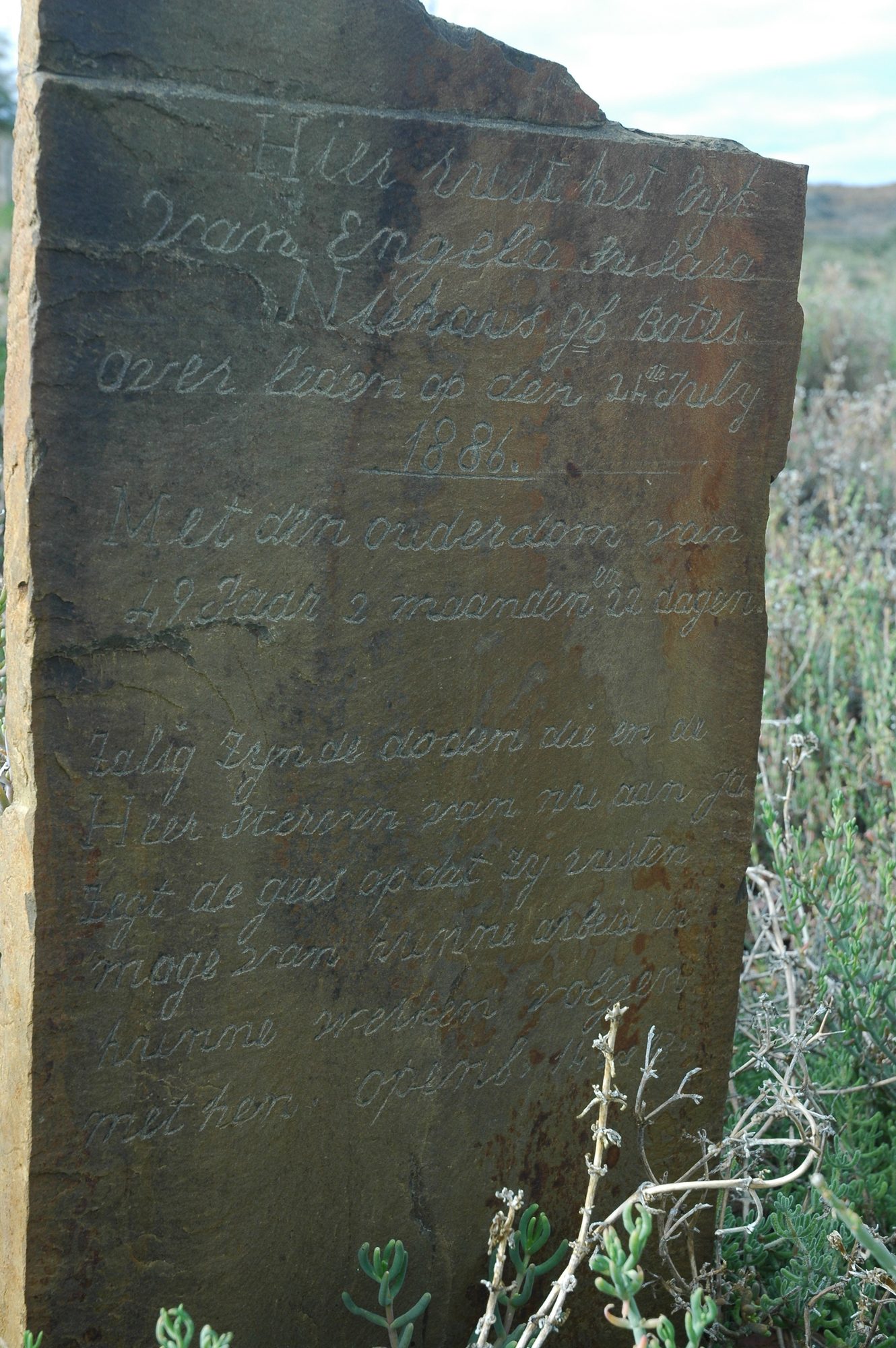
Botma burial ground, Vredendal / Gatsplaas (Spreeufontein Ptn 1), Hier rust het lijk van ENGELA SUSARA NIEHAUS geb BOTES, overleden op den 24 July 1886. Met den ouderdom van 49 jaar 2 maanden en 22 dagen. Then Revelation 14:13: 'Zalig zyn de dooden die in de Heer sterven van nu aan, ja zegt de gees, opdat zy rusten mogen van hunne arbeid, en hunne werken volgen met hen. Openb. 14:13.' Cut in a fine cursive hand across the whole slab.
-
April 1894
document
SG diagram 3762/1898 (pt 1)
P.T.A.Q.5-12
-
April 1894
document
SG diagram 3762/1898 (pt 2)
P.T.A.Q.5-12
- 1909 boundary change subdivision: becomes Lot A (Spreeufontein No. 26 Ptn 3)
- 1909 boundary change subdivision: becomes Lot B (Spreeufontein No. 26 Ptn 4)
- 1909 boundary change subdivision: becomes Lot C (Spreeufontein No. 26 Ptn 5)
-
30 January 1910
burial
Cornelis Jacobus Botma (19 November 1867–30 January 1910)
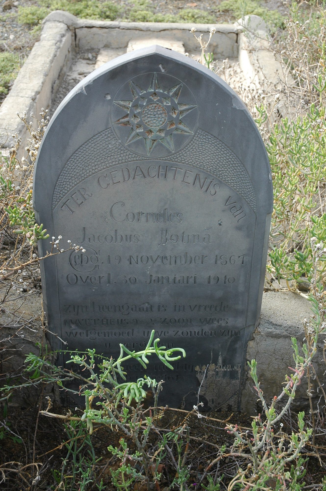
Botma burial ground, Vredendal / Gatsplaas (Spreeufontein Ptn 1), TER GEDACHTENIS van CORNELIS JACOBUS BOTMA, GEB. 19 NOVEMBER 1867, OVERL. 30 JANUARI 1910. A verse follows below and is partly under vegetation in the photograph; not transcribed. The headstone carries a carved sunburst or compass rose above the text.
-
14 May 1939
burial
Johanna Maria Magdalena Bothma (31 March 1861–14 May 1939)
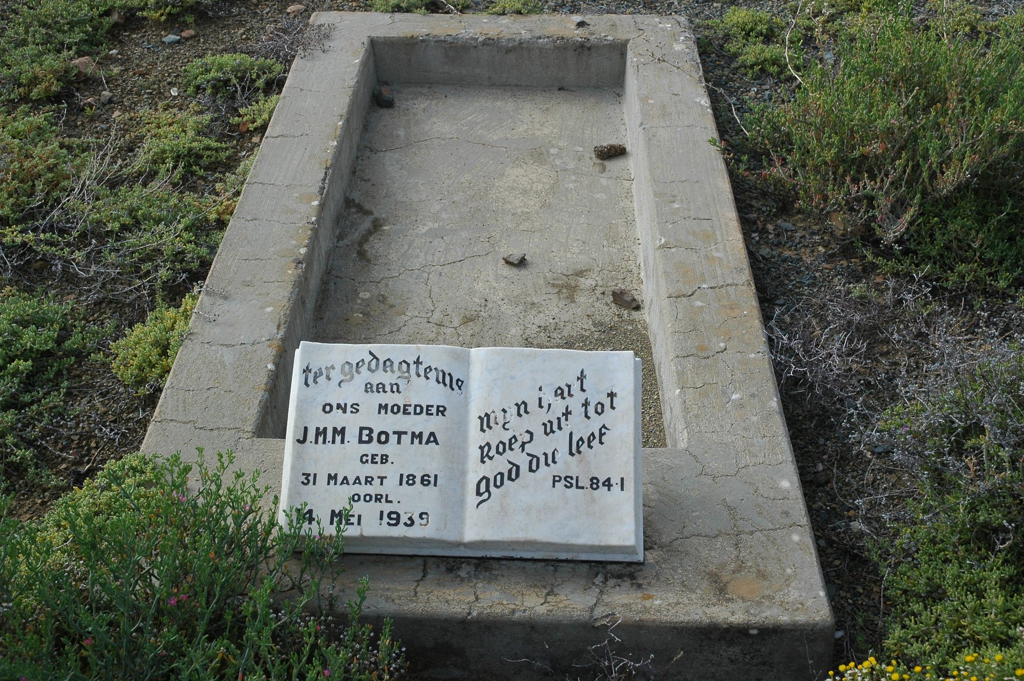
Botma burial ground, Vredendal / Gatsplaas (Spreeufontein Ptn 1), ter gedagtenis AAN ONS MOEDER J.M.M. BOTMA, GEB. 31 MAART 1861, OORL. 14 MEI 1939. Beside it, on the open book: 'my [hele?] hart roep uit tot God die leef' - PSL. 84:1.
-
195X to 1968
ownership
Frans Jacobus Wilhelmus van der Merwe (8 April 1924–8 April 1968)
occupation · confidence medium
-
the 1950s
lived here
Frans Jacobus Wilhelmus van der Merwe (8 April 1924–8 April 1968)
farming
-
18 May 1953
lived here
Catharina van der Merwe (18 May 1953–?)
childhood
-
4 April 1957
lived here
Jacobus Gideon "Deon" van der Merwe (4 April 1957–?)
farming
-
the 2020s
ownership
Jacobus Gideon "Deon" van der Merwe (4 April 1957–?)
trust · owner · confidence medium
- undated boundary change subdivision: from Spreeuw Fontein & Toornits Kraal (Spreeufontein No. 26)
- undated document SG diagram verso 3762/1898 (verso)
-
undated
burial
Gertruida Johanna Swanepoel
Botma burial ground, Vredendal / Gatsplaas (Spreeufontein Ptn 1), Not seen by this project. eGGSA caption: 'SWANEPOEL Gertruida Johanna 1915-'. The dash with no closing year means the photographer read a birth year and no death year, or the death year was illegible.
Bordered by, as the diagram names them
- N Lammer Kraal
- N Riet Fontein
- SE Riet Fontein
- SE Klein Waterval
- S Groot Waterval (Remainder)
- S Klein Fontein
- W Varsche Fontein
Buried on this ground
- Botma burial ground, Vredendal / Gatsplaas (Spreeufontein Ptn 1) 5 graves recorded, 3 identified in this project
The burials also appear on this farm's timeline above, each at its own date.
Photographs
Also bordered by, as the modern cadastre draws it
Ground that touches this farm on the Surveyor-General's current polygons and that none of the diagrams held here names. Derived from the geometry, not read off a document.
- N Lammers Kraal No. 11
- NE Rietfontein No. 12 Remainder
- NE Rietfontein No. 12 Ptn 1
- E Rietfontein No. 12
- E Rietfontein No. 12 Ptn 2
- SE Farm 215
- SE Waterval (Farm 215 Ptn 1)
- SW Bokfontein No. 94 (formerly Waterfall)
- W Spreeuw Fontein & Toornits Kraal (Spreeufontein No. 26)
- W Lot B (Spreeufontein No. 26 Ptn 4)
Documents
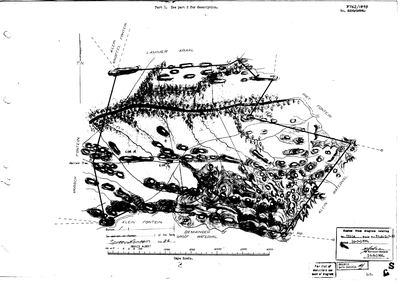 Surveyor-General diagram, 3762/1898 (pt 1), April 1894
10FL3T01.TIF
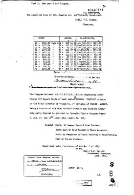 Surveyor-General diagram, 3762/1898 (pt 2), April 1894
10FL3U01.TIF
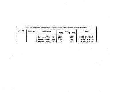 Diagram verso, 3762/1898 (verso)
10FL3V01.TIF
Cadastre
Surveyor-General diagram index for this parcel
Surveyor-General diagram index for the whole farm — where the original survey of this ground sits.
Research notes
Deducted 1850 (deed 1850-16-167) at 19050mg 449sr; resurveyed April 1894 at 18309mg 367sr - the two figures differ by ~740 morgen [TO VERIFY]. Split into Lots A/B/C in 1909.
[9 Aug 2026] THIS PORTION IS VREDENDAL. It was named GATSPLAAS and was renamed Vredendal before F.J.W. van der Merwe (PER-000030) bought it, so before the 1950s. The van der Merwe werf, the Botma burial ground and the 1886 Niehaus stone are all on this ground. Johanna Maria Magdalena Botma's 1939 death notice recording her burial at "Gatsplaas" is therefore a burial on this portion, which is what ties the old name to this ground in a document. PAR-000006 is the same ground under the name Vredendal and the two rows should be merged. See STO-0033.
[13 Aug 2026, SRC-436] NAMED FROM THE 2023 VALUATION ROLL, which gives this portion as "Vredendal" (5227.5890 ha). This row previously read "Spreeufontein Portion 1", which was a farm-and-portion label rather than a name. The roll is a rates document and good evidence for what the ground is called now; it says nothing about what it was called when the portion was cut. The roll confirms from outside what has asserted all along, that Vredendal is Spreeufontein Portion 1. PAR-000006 also carries the name Vredendal as a subdivision of 26; whether the two rows are one parcel is a merge for Frans and is not assumed here.
[14 Aug 2026] MERGED PAR-000006 INTO THIS ROW. They were one farm recorded twice: this row is the cadastral portion, Spreeufontein No. 26 Portion 1, carrying the 5,197 ha polygon and no ownership at all; PAR-000006 was the farm as the family names it, carrying the ownership, the residences and the graves and NO GEOMETRY. So Vredendal - the van der Merwe home farm - could never be drawn on the map, and the family view showed it as a parcel with no ground. The retired row's own note had said 'VREDENDAL IS SPREEUFONTEIN PORTION 1 (PAR-000020) ... PENDING' since it was written; this is that pending merge, done
WHAT THE RETIRED ROW SAID, KEPT VERBATIM: VREDENDAL IS SPREEUFONTEIN PORTION 1 (PAR-000020), cadastre key RE/1/26. The portion was called GATSPLAAS and was renamed Vredendal before Frans Jacobus Wilhelmus van der MerweL (PER-000030) bought it, so before the 1950s . [FAMILY] The van der Merwe family farm: Frans's mother Catharina (b.1953) grew up here; his maternal uncle holds it today VIA A TRUST. PENDING: this row and PAR-000020 are the same ground under two names. Merge or retire one of them; not done here because it touches ownership, grave, story and neighbour links.
[1 Aug 2026, SRC-068] A FLOWER THAT GROWS NOWHERE ELSE. Pat Marincowitz (PER-000179) found a pink nerine with a whitish throat fading to brown on this farm. Dr Desire Hayman of Kirstenbosch, the authority on Amaryllidaceae, confirmed it as a new species from a SINGLE COLONY OF ABOUT 400 PLANTS, 40 km south-east of Leeu-Gamka near the Klein Waterval river, and it was named NERINE MARINCOWITZII for him. Vredendal is where Frans's mother grew up.
[7 Aug 2026] THE PORTION 1 IDENTIFICATION IS NOW CORROBORATED FROM A SECOND, DOCUMENTARY DIRECTION and no longer rests on a geotag alone. Three stones stand in one plot at that coordinate and the second is J.M.M. BOTMA, who is PER-000036 - and HER 1939 DEATH NOTICE SAYS SHE WAS BURIED AT 'GATSPLAAS'. Gatsplaas is the village Lodewyk BothmaM laid out on Spreeufontein after the 1871 gold find [SRC-068]. So a death notice, a family photograph's geotag and Frans's own knowledge of the ground all put the same spot inside Spreeufontein Portion 1. What still keeps this at medium rather than high: none of the three is a survey, and a burial ground can sit on a farm's edge. A deed or diagram naming Vredendal is still the thing that would settle it.
[7 Aug 2026] THE 1886 GRAVE HERE IS A NIEHAUS, NOT A BOTMA. GRV-0025 is ENGELA SUSARA NIEHAUS, born BOTES, who died on this ground on 24 July 1886 aged 49 years 2 months 22 days, when the farm was still called SPREEUFONTEIN. Her husband Hendrik Willem Storm NiehausM carried his mother's surname STORM as a given name, and [FAMILY] her own mother was a Storm as well. The plot therefore holds a Niehaus of 1886 and two Botma of 1910 and 1939 - connected families, not one surname's ground. LEAD-0127.
[7 Aug 2026, SRC-309] THE PORTION 1 IDENTIFICATION IS NOW AS FIRM AS THIS PROJECT CAN MAKE IT WITHOUT A DEED. eGGSA's independent GPS for this burial ground is -32.956117, 22.283250, THREE METRES from the geotag this project has been using. The geotag was the weak link in the chain - written in software five years after the photograph - and it is no longer weak. The point still falls inside the polygon of Spreeufontein Portion 1.
[14 Aug 2026] PLK-000131 was dropped in the same pass. It was a `same_as` link recording that PAR-000006 and this row were one farm - written on 13 Aug as the alternative to merging them, with the reason 'both keep their ids'. Once the merge re-pointed it, the link ran from this row to itself, which asserts nothing. The fact it carried is not lost: it is the first paragraph of this note.
The research behind this page, kept separate from it: dated working notes, open questions, and what is not yet settled.
Open questions
-
Read the graves ACROSS the farms, and against the online grave indexes
priority 1 · LEAD-0127
Storm, Botes, Niehaus, Botma, Beukes and Freysen appear on stones on Varsche Fontein and on Vredendal/Spreeufontein, and they intermarry. What does the picture look like when the burial grounds are read as one body of evidence rather than farm by farm, and what do the published grave indexes add?
What would settle it Nothing settles a question this shape. What it produces is a map: which families are buried where, who married whom, and which farms they moved between.
-
Our portion numbers do not match the SG on Vrolykheid and Spreeufontein
priority 2 · LEAD-0008
Do our portion numbers for Vrolykheid and Spreeufontein correspond to the Surveyor-General portion numbers, or are they our own sequence?
What would settle it The portion number printed on each diagram, against the SG portion number in the cadastre.
-
Whose grave is on Vredendal, 24 July 1886?
priority 2 · LEAD-0120
A slate headstone lying flat on Vredendal is cut for a burial of 24 July 1886. The surname reads as Botha and is not certain, the given name and the age are illegible on the photograph. Who is buried there, and is it one grave or a family plot?
What would settle it A readable surname and age from the stone, or a death notice for a Botha at Spreeufontein in July 1886.
-
Is the ruin on Spreeufontein Portion 1 a gold-rush building, and are the workings above it diggings?
priority 2 · LEAD-0121
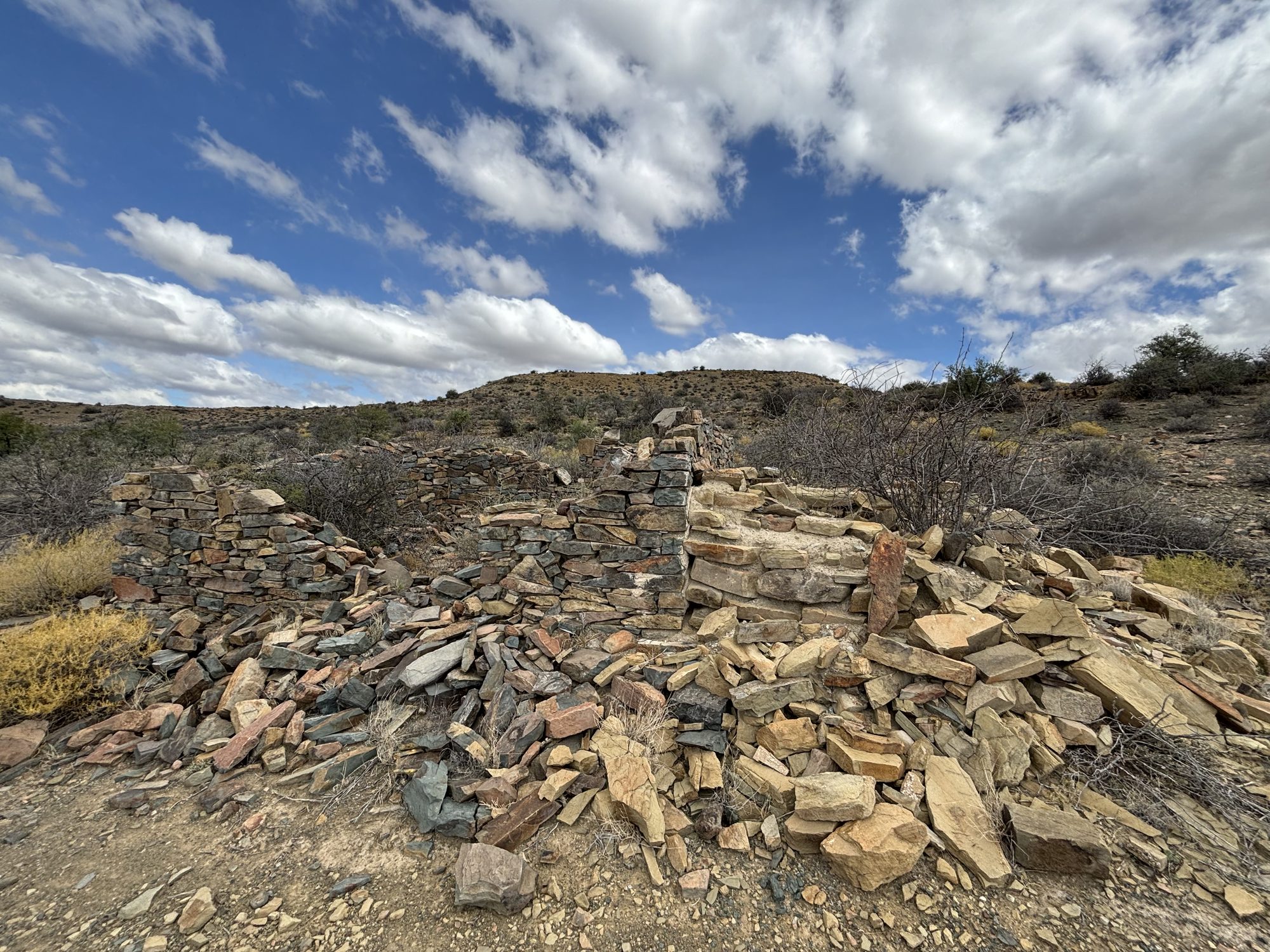
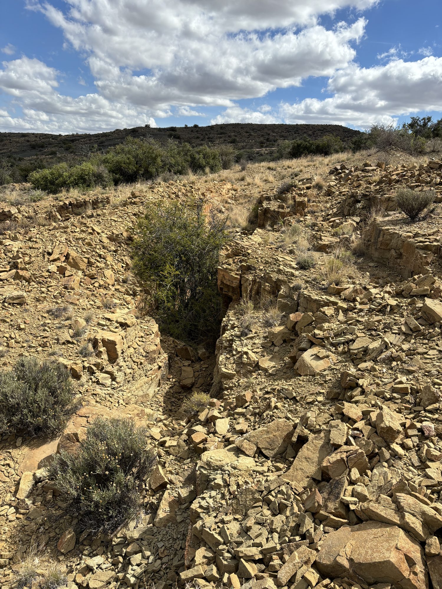
Two photographs of 29 March 2024 carry real device coordinates on Spreeufontein Portion 1: a collapsed dry-stone building at -32.969131, 22.290139 (855 m) and broken rock and spoil 232 m south and 74 m higher at -32.971036, 22.289128 (929 m). Do either belong to the 1891 rush, or to Gatsplaas, or to ordinary farming?
What would settle it Any contemporary map or report locating the diggings or the village; or a visit recording the ruin's plan, dimensions and any datable material - a fireplace, window openings, mortar, bottle glass, a dump. [14 Aug 2026] TWO CALL NUMBERS NOW ANSWER THE FIRST HALF OF THIS: CCP1/2/1/78 ref A12 for 1891 and CCP1/2/1/23 ref A30 for 1871. What they will not give is a coordinate for the ruin in IMG-0010; only a visit or a map does that.
-
Spreeufontein drew mineral interest again in 1910-1912, and this record ends the story in 1891
priority 2 · LEAD-0190
Two NAAIRS index lines put mineral activity on Spreeufontein a generation after the rush: an ALLEGED FIND OF CINNABAR in 1910-1911 (KAB SG 3/2/1/35 sys 01 ref MDC770) and THE SPREEUWFONTEIN (PRINCE ALBERT) GOLD MINING SYNDICATE LIMITED, registered under Act 25 of 1892 in 1912 (KAB LC 295 sys 02 ref 1210). What happened on that ground between about 1908 and the First World War, and who was behind the syndicate?
What would settle it Either file. Both would give names, dates and what came of it.
What the record is missing
-
“Klein Fontein” is named as a neighbour 4 times and we hold no parcel for it
second order · B3 unheld-farm
4 separate surveys in this model put Klein Fontein on the boundary of ground we do hold (PAR-000002, PAR-000018, PAR-000020). It has no parcel of its own here, so nothing is known about who held it or when, while it borders farms at the centre of the project.
What would settle it The Surveyor-General's farm index for the registration division will give it a farm number and a diagram; the cadastre pull in `data/fetch_cadastre.py` then places it on the map.
-
“Riet Fontein” is named as a neighbour 4 times and we hold no parcel for it
second order · B3 unheld-farm
4 separate surveys in this model put Riet Fontein on the boundary of ground we do hold (PAR-000005, PAR-000020, PAR-000025). It has no parcel of its own here, so nothing is known about who held it or when, while it borders farms at the centre of the project.
What would settle it The Surveyor-General's farm index for the registration division will give it a farm number and a diagram; the cadastre pull in `data/fetch_cadastre.py` then places it on the map.
-
“Groot Waterval (Remainder)” is named as a neighbour 2 times and we hold no parcel for it
third order · B3 unheld-farm
2 separate surveys in this model put Groot Waterval (Remainder) on the boundary of ground we do hold (PAR-000020, PAR-000025). It has no parcel of its own here, so nothing is known about who held it or when, while it borders farms at the centre of the project.
What would settle it The Surveyor-General's farm index for the registration division will give it a farm number and a diagram; the cadastre pull in `data/fetch_cadastre.py` then places it on the map.
-
“Lammer Kraal” is named as a neighbour 2 times and we hold no parcel for it
third order · B3 unheld-farm
2 separate surveys in this model put Lammer Kraal on the boundary of ground we do hold (PAR-000020, PAR-000156). It has no parcel of its own here, so nothing is known about who held it or when, while it borders farms at the centre of the project.
What would settle it The Surveyor-General's farm index for the registration division will give it a farm number and a diagram; the cadastre pull in `data/fetch_cadastre.py` then places it on the map.
Found by breaks.py reading the model against itself, not written by hand,
each one is a shape of missing record, not a fault in the data.
The whole set is on the
questions page.