Spreeuw Fontein & Toornits Kraal (Spreeufontein No. 26)
26 on the cadastre · on record 1834–1990 · show on the map
- Farm number
- No. 26
- On the cadastre
- 26, whole farmregistered as SPREEUW FONTEIN
- District
- Prince Albert
- Extent, as the diagram states it
- 23139 morgen 450 roods (1834)
- Modern surveyed area
- 15666.1 ha
The historic extent and the modern surveyed area are two separate measurements and are not presented here as confirming each other. The first is what a surveyor wrote on a diagram, usually in morgen. The second is what the modern cadastre draws.
Why this farm is here
Cornelis Floris Johannes Meyer held it. Connected to the Oosthuizen, Marincowitz or Van der Merwe lines BY MARRIAGE, not by blood, 5 steps on the shortest path. 54 km from Klaarstroom.
- Cornelis Floris Johannes Meyer
- parent of Johanna Catharina Willemina Meyer
- married to Jacobus Strydom
- child of Daniel Jacobus Strydom
- parent of David Jan Strydom (Daniel son)
- married to Susanna Maria Oosthuizen
Each step is a recorded parentage or marriage in this model, and the shortest one the record supports, follow the names to check it.
- story A written history is set on this ground The Prince Albert gold rush
- story A written history is set on this ground The fifteenth of April, 1841
- story A written history names this ground Vrolykheid No. 177: a farm history
- story A written history names this ground Rondabel No. 124: a farm history
- …and 2 more, listed in full further down this page.
Stories
- about this farm
The Prince Albert gold rush
An aardvark turns up a nugget on Spreeuwfontein in 1871; twenty years later a shepherd finds a second one and five hundred people arrive. 1,042 claims yield 504 ounces. The diggers' village was called Gatsplaas.
- about this farm
The fifteenth of April, 1841
One surveyor works the Koup for two seasons. Eight years later, on a single day, the Crown turns a dozen loan farms into freehold - and the map of the district is set for a century.
- mentions this farm
Vrolykheid No. 177: a farm history
The farm where the paper and the people disagree: Stretch's 1833 survey already carrying the names of portions not cut for another century, two titles granted on one day in 1841 - one to an Oosthuisen and one to an 'N. Hitge' whose deed four later portions cite instead - a Trieste immigrant who married a Hitge in 1844 and died holding the farm in 1890, and the death notice that finally put the Hitges on the ground.
- mentions this farm
Rondabel No. 124: a farm history
From a loan-farm widow who signed with a mark to the Marincowitz farm of today: the full documented history of Rondabel No. 124 - the Venter household of 1829, the twelve-farm grant day of 1841, the Oosthuizen-Theron partnership of 1868, the 1910-34 subdivisions, and the two graves by the huis nobody has read.
- set here
What is under the Koup
Four times people have come to this country certain there was something valuable under it: gold in 1871 and 1891, oil in the middle 1960s, uranium from 1969 to 1985, and shale gas from 2011. A drill bit still lies on Rondabel. The boreholes SOEKOR drilled for oil are the same cores that deflated the shale gas estimate fifty years later.
- about this farm
Cut, and then stitched
This project holds 124 boundary acts: 96 subdivisions and 20 consolidations. Sorted by date they tell one story with a turning point. The district cut ground for a hundred and fifty years; from 1970 it has only stitched.
- set here
Vredendal: three surnames on the stones, one family in the house
Vredendal is a werf name on Spreeufontein No. 26, the farm the district called Gatsplaas. Five graves carrying three surnames, an 1886 slate slab whose inscription dates a woman to the day and whose line runs unbroken back to Enkhuizen in 1744, and then a household: the van der Merwes, and a man who died on his own birthday.
What the record holds, in order
-
1834
document
SG diagram 432/1834
Bf.W.Q.5-26
-
1841-04-15 to 1848-07-21
ownership
Cornelis Floris Johannes Meyer (15 July 1791–21 July 1848)
Perpetual Quitrent · grant · confidence high
- 1850 boundary change subdivision: becomes Vredendal (Spreeufontein No. 26 Ptn 1)
-
1871~ to 1874
ownership
Lodewyk Bothma (1802–1874)
owner · confidence medium
- 1872 boundary change subdivision: becomes Spreeufontein No. 26 Ptn 2
- 20 August 1891 document newspaper
- 1903 boundary change remainder: becomes Klein Waterval (Spreeufontein No. 26 Remainder)
-
14 May 1939
document
death notice
entry no. 40
-
1939
burial
J.M.M Botma
Botma burial ground, Vredendal / Gatsplaas (Spreeufontein Ptn 1)
- 1990 boundary change consolidation: becomes Farm 215
- undated boundary change subdivision: becomes Vredendal (Spreeufontein No. 26 Ptn 1)
- undated boundary change subdivision: becomes Lot A (Spreeufontein No. 26 Ptn 3)
- undated boundary change subdivision: becomes Lot B (Spreeufontein No. 26 Ptn 4)
- undated boundary change subdivision: becomes Lot C (Spreeufontein No. 26 Ptn 5)
- undated document SG diagram verso 432/1834 (verso)
Ground cut out of this farm
- Vredendal (Spreeufontein No. 26 Ptn 1) 1/26 · 5197.5 ha
- Spreeufontein No. 26 Ptn 2
- Lot A (Spreeufontein No. 26 Ptn 3) 3/26 · 3222.5 ha
- Lot B (Spreeufontein No. 26 Ptn 4) 4/26 · 5237.3 ha
- Lot C (Spreeufontein No. 26 Ptn 5) 5/26 · 4.3 ha
- Klein Waterval (Spreeufontein No. 26 Remainder)
Bordered by, as the diagram names them
- N Ongeluk's Fontein
- S Waterval
- E Riet Fontein
- W Varsche Fontein
Also bordered by, as the modern cadastre draws it
Ground that touches this farm on the Surveyor-General's current polygons and that none of the diagrams held here names. Derived from the geometry, not read off a document.
- N Lammers Kraal No. 11
- NE Rietfontein No. 12 Remainder
- E Vredendal (Spreeufontein No. 26 Ptn 1)
- E Waterval (Farm 215 Ptn 1)
- E Rietfontein No. 12
- E Rietfontein No. 12 Ptn 1
- E Rietfontein No. 12 Ptn 2
- SE Farm 215
- SW Bokfontein No. 94 (formerly Waterfall)
- W Welbedacht (Varsche Fontein No. 27 Ptn 4)
- W Varsche Fontein No. 27 Remainder
- W Lot A (Spreeufontein No. 26 Ptn 3)
- W Lot B (Spreeufontein No. 26 Ptn 4)
Documents
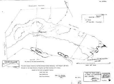 Surveyor-General diagram, 432/1834, 1834
SCAN199.TIF
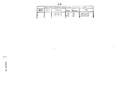 Diagram verso, 432/1834 (verso)
SCAN200.TIF
record-image (28).jpg
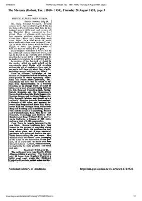 Newspaper, 20 August 1891
gatsplaas vredendal spreeuwfontein goud.pdf
Cadastre
Surveyor-General diagram index for this parcel
Research notes
Site of the 1891 Prince Albert gold rush. Known locally as "GATSPLAAS" - [FAMILY] Frans: it was Gatsplaas when the gold was found; documented in an official 1939 death notice as a burial place (DOC-0017), while the 1891 press called it Spreeuwfontein. Granted 15 Apr 1841 to C.F.J. Meyer, folio 973. Broken up from 1850. Eastern neighbour of Varsche Fontein. [FAMILY] Vredendal, where Frans's mother grew up and which his maternal uncle holds via a trust, is part of this farm - which portion is not yet established [TO VERIFY].
[3 Aug 2026, SRC-202] WHERE IT WENT, AND WHERE IT CAME FROM. The 1990 consolidation LG 7373-90 (DOC-0168) takes the REMAINDER of this farm, together with the Restant of its Gedeelte 2 and its Gedeelte 6, into DIE PLAAS NR 215 (PAR-000134) of 10 710 ha. That extends this farm's record past the 1939 end it had here. The same document gives the remainder its own diagram, KAART 1/1903, and - more useful - the ORIGINAL GRANT: GRONDBRIEF NR P.A.Q. 6-1. Neither was held before. [TO VERIFY against the grant itself, which is not held.]
[9 Aug 2026] GATSPLAAS WAS PORTION 1 OF THIS FARM, and it was renamed VREDENDAL before F.J.W. van der Merwe bought it in or before the 1950s . So the name belongs to PAR-000020 rather than to farm 26 as a whole.
[8 Aug 2026, DOC-0218] A POSSIBLE ORIGIN FOR THAT NAME. The eastern neighbour, Riet Fontein No. 12 (PAR-000156), has a watercourse called the GATS RIVER drawn across its 1868 diagram, running towards the boundary the two farms share. A place taking its everyday name from the river beside it is ordinary. NOT PROVEN: the 1868 sheet does not use the name Gatsplaas, and "gat" is a common element in Karoo place names. [TO VERIFY] whether the Gats River is drawn on Spreeufontein's own diagrams.
[9 Aug 2026] THE 12.8% SHORTFALL ON THIS FARM IS NOT A PUZZLE, IT IS TWO EMPTY FIELDS. checks.py reports farm 26's portions summing to 13,661.6 ha against 15,666.1. The four portions that carry an area are Portions 1, 3, 4 and 5; PORTION 2 (PAR-000021) AND THE REMAINDER, KLEIN WATERVAL (PAR-000025), CARRY NONE. The gap, 2,004.5 ha, is those two rows. Nothing here contradicts anything; the model simply has no figure for a fifth of this farm. Fill either row from the cadastre and the sum closes.
The research behind this page, kept separate from it: dated working notes, open questions, and what is not yet settled.
Open questions
-
Six parcels whose surveyed extent is far from their polygon with no reason recorded
priority 2 · LEAD-0093
For each, is the extent mistyped, or did ground leave the farm without a note?
What would settle it The deduction table. It lists portion, name, extent, diagram and deed on one line.
-
Is the ruin on Spreeufontein Portion 1 a gold-rush building, and are the workings above it diggings?
priority 2 · LEAD-0121
Two photographs of 29 March 2024 carry real device coordinates on Spreeufontein Portion 1: a collapsed dry-stone building at -32.969131, 22.290139 (855 m) and broken rock and spoil 232 m south and 74 m higher at -32.971036, 22.289128 (929 m). Do either belong to the 1891 rush, or to Gatsplaas, or to ordinary farming?
What would settle it Any contemporary map or report locating the diggings or the village; or a visit recording the ruin's plan, dimensions and any datable material - a fireplace, window openings, mortar, bottle glass, a dump. [14 Aug 2026] TWO CALL NUMBERS NOW ANSWER THE FIRST HALF OF THIS: CCP1/2/1/78 ref A12 for 1891 and CCP1/2/1/23 ref A30 for 1871. What they will not give is a coordinate for the ruin in IMG-0010; only a visit or a map does that.
-
Spreeufontein drew mineral interest again in 1910-1912, and this record ends the story in 1891
priority 2 · LEAD-0190
Two NAAIRS index lines put mineral activity on Spreeufontein a generation after the rush: an ALLEGED FIND OF CINNABAR in 1910-1911 (KAB SG 3/2/1/35 sys 01 ref MDC770) and THE SPREEUWFONTEIN (PRINCE ALBERT) GOLD MINING SYNDICATE LIMITED, registered under Act 25 of 1892 in 1912 (KAB LC 295 sys 02 ref 1210). What happened on that ground between about 1908 and the First World War, and who was behind the syndicate?
What would settle it Either file. Both would give names, dates and what came of it.
What the record is missing
-
30 years, and the ground changes hands to nobody we can follow
first order · B1 succession
On Spreeuw Fontein & Toornits Kraal (Spreeufontein No. 26), Cornelis Floris Johannes MeyerH is the last owner recorded from 1841-04-15, and the next entry is Lodewyk BothmaH from 1871~, 30 years later, with no person in common. No document records the handover at all.
What would settle it The Deeds Office transfer register for this farm between 1841 and 1871. A transfer names its predecessor in title, so one deed closes the whole gap.
-
The record stops in 1874 and never resumes
second order · B2 trail-ends
Spreeuw Fontein & Toornits Kraal (Spreeufontein No. 26) was worked as far as 1874, with Lodewyk BothmaH the last owner on record. 152 years follow with nothing. Who held it after that, and is it still one farm?
What would settle it The current title deed traced backwards, each transfer names the one before it, or the Surveyor-General's subdivision diagrams, which are what usually explain a farm going quiet.
-
“Riet Fontein” is named as a neighbour 4 times and we hold no parcel for it
second order · B3 unheld-farm
4 separate surveys in this model put Riet Fontein on the boundary of ground we do hold (PAR-000005, PAR-000020, PAR-000025). It has no parcel of its own here, so nothing is known about who held it or when, while it borders farms at the centre of the project.
What would settle it The Surveyor-General's farm index for the registration division will give it a farm number and a diagram; the cadastre pull in `data/fetch_cadastre.py` then places it on the map.
Found by breaks.py reading the model against itself, not written by hand,
each one is a shape of missing record, not a fault in the data.
The whole set is on the
questions page.