Klipfontein No. 171 (Witte Klip)
171 on the cadastre · on record 1833–1841 · show on the map
- Farm number
- No. 171
- On the cadastre
- 171, whole farmregistered as KLIPFONTEIN
- District
- Prince Albert
- Extent, as the diagram states it
- 5514 morgen 450 roods
- Modern surveyed area
- 1465.0 ha
The historic extent and the modern surveyed area are two separate measurements and are not presented here as confirming each other. The first is what a surveyor wrote on a diagram, usually in morgen. The second is what the modern cadastre draws.
Why this farm is here
William Geyer held it, and no kinship to the Oosthuizen, Marincowitz or Van der Merwe lines is recorded, this ground entered through the land, not the family. 18 km from Klaarstroom.
- story A written history names this ground Vrolykheid No. 177: a farm history
- story A written history names this ground Rondabel No. 124: a farm history
- story A written history names this ground Middelwater No. 169: a farm history
- story A written history names this ground The fifteenth of April, 1841
- …and 2 more, listed in full further down this page.
Stories
- mentions this farm
Vrolykheid No. 177: a farm history
The farm where the paper and the people disagree: Stretch's 1833 survey already carrying the names of portions not cut for another century, two titles granted on one day in 1841 - one to an Oosthuisen and one to an 'N. Hitge' whose deed four later portions cite instead - a Trieste immigrant who married a Hitge in 1844 and died holding the farm in 1890, and the death notice that finally put the Hitges on the ground.
- mentions this farm
Rondabel No. 124: a farm history
From a loan-farm widow who signed with a mark to the Marincowitz farm of today: the full documented history of Rondabel No. 124 - the Venter household of 1829, the twelve-farm grant day of 1841, the Oosthuizen-Theron partnership of 1868, the 1910-34 subdivisions, and the two graves by the huis nobody has read.
- mentions this farm
Middelwater No. 169: a farm history
From a loan farm on the Zwartberg to eight cadastral parcels: the full documented history of Middelwater No. 169 - Stretch's 1833 survey for Okert Oosthuizen, the twelve-farm grant day of 1841, the 1883 resurvey and the 1884 quitrent to J.D.J. Oosthuysen 'and another', the portions cut off for a spring called Vaste Water and a place called Avondrust, and the 1990 power-line survey whose coordinates finally put the farm on a map.
- mentions this farm
The fifteenth of April, 1841
One surveyor works the Koup for two seasons. Eight years later, on a single day, the Crown turns a dozen loan farms into freehold - and the map of the district is set for a century.
What the record holds, in order
-
August 1833
document
SG diagram 369/1833
Bf.Q.5-43
-
August 1833
ownership
William Geyer
loan farm · survey · confidence high
-
15 April 1841
ownership
owner not named in the record
Perpetual Quitrent · grant · confidence medium
Bordered by, as the diagram names them
- NE Government ground
- NW Knabzaak fontein
- S Oorlogs Kloof and Roode wilde Else
Also bordered by, as the modern cadastre draws it
Ground that touches this farm on the Surveyor-General's current polygons and that none of the diagrams held here names. Derived from the geometry, not read off a document.
- N Kopjes Kraal
- N Kopjes Kraal No. 123 Remainder
- E Klipfontein A No. 174
- SE Klipfontein A No. 174 Remainder
- W Klein Elandsfontein (Rondabel No. 124 Ptn 7)
- W Die Kruine No. 170
- NW Rondabel
- NW Driehoek (Rondabel No. 124 Ptn 4)
Documents
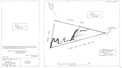 Surveyor-General diagram, 369/1833, August 1833
SCAN533.jpg
Cadastre
Surveyor-General diagram index for this parcel
Research notes
[31 Jul 2026 inbox] "The annexed Diagram represents the Farm Witte Klip or Klip Fontein containing 5514 Morgen 450 roods surveyed for William GeyerH situated in the Traka Field Cornetcy. Beaufort District. Bounded on the NE by Government ground, NW Knabzaak fontein, South Oorlogs Kloof." (Sgd.) C. Lennox Stretch, land surveyor, August 1833 - the same surveyor in the same season as Klaarstroom No.184 (DOC-0051) and Klein Sleutlefontein No.127 (DOC-0091). Copied from the diagram relating to D/G Bf.Q.5-43. [DIAGRAM] DOC-0112. THE 1833 DIAGRAM IS CANCELLED: "VIDE Subst. Dgm. 501/1867, P.A.Q. 1-22, (Sgd.) J.T.E. Bubb for Surveyor General, 18.11.1966" - so the farm was resurveyed in 1867 and retitled, in the same batch as Rondabel's 502/1867 / P.A.Q.1-21 (DOC-0024). EXTENT AND MODERN AREA ARE NOT COMPARABLE HERE and are not offered as such: the 1833 survey is 5,514 morgen (~4,724 ha) and the modern farm 171 is 1,757.1 ha, because the 1867 substitution redrew it. Internal features named on the sheet: Klip fontein, Witte Klip, Truintjes Kraal, and a 'small spring common to Witte Klip'. NAME TRAP: farm 171 and farm 174 are BOTH called Klipfontein and are different ground - see PAR-000083.
The research behind this page, kept separate from it: dated working notes, open questions, and what is not yet settled.
What the record is missing
-
The record stops in 1841 and never resumes
second order · B2 trail-ends
Klipfontein No. 171 (Witte Klip) was worked as far as 1841-04-15, with an unnamed holder the last owner on record. 185 years follow with nothing. Who held it after that, and is it still one farm?
What would settle it The current title deed traced backwards, each transfer names the one before it, or the Surveyor-General's subdivision diagrams, which are what usually explain a farm going quiet.
-
A tenure with no one in it
second order · B7 no-owner
OWN-000070 records a grant on Klipfontein No. 171 (Witte Klip) from 1841-04-15 and names no party. Either the holder was never read off the document, or the publishing rule withheld them, the page cannot tell you which, and neither can this.
What would settle it Re-read DOC-0112.
Found by breaks.py reading the model against itself, not written by hand,
each one is a shape of missing record, not a fault in the data.
The whole set is on the
questions page.