Part of Rondabel
Klein Elandsfontein (Rondabel No. 124 Ptn 7)
7/124 on the cadastre · on record 1919–1934 · show on the map
The farm's own history, the grant, the original survey, sits on that page.
- Farm number
- No. 124
- Portion
- 7
- On the cadastre
- 7/124, portionregistered as RONDABLE
- District
- Prince Albert
- Extent, as the diagram states it
- 1544 morgen 361 sq roods
- Modern surveyed area
- 1300.0 ha
The historic extent and the modern surveyed area are two separate measurements and are not presented here as confirming each other. The first is what a surveyor wrote on a diagram, usually in morgen. The second is what the modern cadastre draws.
Why this farm is here
Gerolm Samuel Marincowitz held it. 16 km from Klaarstroom.
Gerolm Samuel Marincowitz is on record on this ground directly. No trace needed.
- story A written history is set on this ground Rondabel No. 124: a farm history
- parcel Cut out of Rondabel
- document A document in the collection describes this ground DOC-0048
Stories
- about this farm
Rondabel No. 124: a farm history
From a loan-farm widow who signed with a mark to the Marincowitz farm of today: the full documented history of Rondabel No. 124 - the Venter household of 1829, the twelve-farm grant day of 1841, the Oosthuizen-Theron partnership of 1868, the 1910-34 subdivisions, and the two graves by the huis nobody has read.
What the record holds, in order
-
January 1919
document
SG diagram 3273/1933
3875
- 1933 boundary change subdivision: from Rondabel
-
16 May 1934
ownership
Gerolm Samuel Marincowitz (22 June 1870–30 October 1941)
transfer · confidence high
Also bordered by, as the modern cadastre draws it
Ground that touches this farm on the Surveyor-General's current polygons and that none of the diagrams held here names. Derived from the geometry, not read off a document.
- N Rondawel (Rondabel No. 124 Ptn 1)
- NE Driehoek (Rondabel No. 124 Ptn 4)
- E Klipfontein No. 171 (Witte Klip)
- S Oorlogs Kloof No. 172 (Roode Els Bosch and Oorlogs Kloof)
- W Die Kruine No. 170
- NW Rondabel
- NW Elandsfontein (Rondabel No. 124 Ptn 6)
Documents
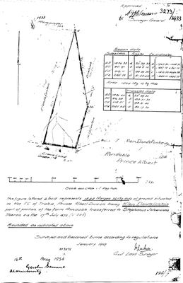 Surveyor-General diagram, 3273/1933, January 1919
10TSVT01 (1).TIF
Cadastre
Surveyor-General diagram index for this parcel
Surveyor-General diagram index for the whole farm — where the original survey of this ground sits.
Research notes
SG Dgm 3273/1933. Transferred to Gerolm Samuel MarincowitzH, 16 May 1934.
[3 Aug 2026, SRC-226] ITS DIAGRAM, ITS ORIGIN AND ITS BUYER. Dgm 3273/1933, surveyed January 1919 by J. Loubser: 1544 morgen 361 square roods in the field cornetcy of Traka, "being KLEIN ELANDSFONTEIN part of portion of the farm Rondable, transferred to STEPHANUS JOHANNES THERON on the 17th July 1872 (No. 208)" - so this ground comes out of the THERON half of the 1868 joint grant. A later hand at the foot records the sale: "16th May 1934 - GEROLM SAMUEL MARINCOWITZ", matching deed 3875 of 16.5.1934 in the parent deduction table. PROBABLY PER-000056 / PER-000521, Gerolm Samuel MarincowitzH 1870-1941 - aged 64 in 1934, an uncommon name, and the right district. Three legs, not one, but still [TO VERIFY]. NOTE ALSO that this model holds that man TWICE, PER-000056 and PER-000521, with identical names and identical dates.
[13 Aug 2026] Renamed to the one form this model uses for every portion - the portion's own name, then the parent farm, its number and the portion in brackets - so that a name is legible in a list, a search result and a map popup without the reader having to know which farm number is which. It read "Klein Elandsfontein (Rondabel Ptn 7)" before. Nothing about the ground changed.
The research behind this page, kept separate from it: dated working notes, open questions, and what is not yet settled.
Open questions
-
Morgen or hectares? extent_text may be inconsistent
priority 1 · LEAD-0007
Are the figures in parcels.extent_text really morgen, or are some of them hectares mislabelled as morgen?
What would settle it Reading the figure and its unit directly off the diagrams for the nine flagged parcels.
What the record is missing
-
The record stops in 1934 and never resumes
third order · B2 trail-ends
Klein Elandsfontein (Rondabel No. 124 Ptn 7) was worked as far as 1934-05-16, with Gerolm Samuel MarincowitzH the last owner on record. 92 years follow with nothing. Who held it after that, and is it still one farm?
What would settle it The current title deed traced backwards, each transfer names the one before it, or the Surveyor-General's subdivision diagrams, which are what usually explain a farm going quiet.
Found by breaks.py reading the model against itself, not written by hand,
each one is a shape of missing record, not a fault in the data.
The whole set is on the
questions page.