Part of Spreeuw Fontein & Toornits Kraal (Spreeufontein No. 26)
Lot C (Spreeufontein No. 26 Ptn 5)
5/26 on the cadastre · on record 1909 · show on the map
The farm's own history, the grant, the original survey, sits on that page.
- Farm number
- No. 26
- Portion
- 5
- On the cadastre
- 5/26, portionregistered as SPREEUW FONTEIN
- District
- Prince Albert
- Extent, as the diagram states it
- 4 morgen 480 sq roods
- Modern surveyed area
- 4.3 ha
The historic extent and the modern surveyed area are two separate measurements and are not presented here as confirming each other. The first is what a surveyor wrote on a diagram, usually in morgen. The second is what the modern cadastre draws.
Why this farm is here
Jacob A. Niehaus held it, and no kinship to the Oosthuizen, Marincowitz or Van der Merwe lines is recorded, this ground entered through the land, not the family. 54 km from Klaarstroom.
- parcel Cut out of Spreeuw Fontein & Toornits Kraal (Spreeufontein No. 26)
- parcel Cut out of Vredendal (Spreeufontein No. 26 Ptn 1)
- document A document in the collection describes this ground DOC-0075
What the record holds, in order
- 1909 boundary change subdivision: from Vredendal (Spreeufontein No. 26 Ptn 1)
-
April 1909
document
SG diagram 947/1909
5220
-
7 August 1909
ownership
Jacob A. Niehaus
transfer · confidence high
- undated boundary change subdivision: from Spreeuw Fontein & Toornits Kraal (Spreeufontein No. 26)
Also bordered by, as the modern cadastre draws it
Ground that touches this farm on the Surveyor-General's current polygons and that none of the diagrams held here names. Derived from the geometry, not read off a document.
Documents
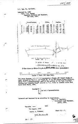 Surveyor-General diagram, 947/1909, April 1909
10TRNV01 (1).TIF
Cadastre
Surveyor-General diagram index for this parcel
Surveyor-General diagram index for the whole farm — where the original survey of this ground sits.
Research notes
cut from Portion 1 in 1909; deed 5220 of 7.8.1909 [corrected 29 Jul 2026 from "1909-83-5220" - DOC-0075's own transfer block reads "Transfer 5220, 7th August 1909, Jacob A. NiehausH"]. Tiny - probably a water or building site. [29 Jul 2026] Own diagram found: DOC-0075 (SG Dgm 947/1909) - "Lot C Spreeuwfontein", transferred to Jacob A. NiehausH (PER-000322).
[13 Aug 2026] Renamed to the one form this model uses for every portion - the portion's own name, then the parent farm, its number and the portion in brackets - so that a name is legible in a list, a search result and a map popup without the reader having to know which farm number is which. It read "Spreeufontein Portion 5 (Lot C)" before. Nothing about the ground changed.
The research behind this page, kept separate from it: dated working notes, open questions, and what is not yet settled.
What the record is missing
-
The record stops in 1909 and never resumes
second order · B2 trail-ends
Lot C (Spreeufontein No. 26 Ptn 5) was worked as far as 1909-08-07, with Jacob A. NiehausH the last owner on record. 117 years follow with nothing. Who held it after that, and is it still one farm?
What would settle it The current title deed traced backwards, each transfer names the one before it, or the Surveyor-General's subdivision diagrams, which are what usually explain a farm going quiet.
Found by breaks.py reading the model against itself, not written by hand,
each one is a shape of missing record, not a fault in the data.
The whole set is on the
questions page.