Part of Doorn Kraal No. 116
Doorn Kraal No. 116 Ptn 1
1/116 on the cadastre · on record 1863 · show on the map
The farm's own history, the grant, the original survey, sits on that page.
- Farm number
- No. 116
- Portion
- 1
- On the cadastre
- 1/116, portionregistered as DOORN KRAAL
- District
- Prince Albert
- Extent, as the diagram states it
- 2659 morgen
- Modern surveyed area
- 994.2 ha
The historic extent and the modern surveyed area are two separate measurements and are not presented here as confirming each other. The first is what a surveyor wrote on a diagram, usually in morgen. The second is what the modern cadastre draws.
Why this farm is here
A piece of a farm already in this model. 39 km from Klaarstroom.
- parcel Cut out of Doorn Kraal No. 116
- document A document in the collection describes this ground DOC-0248
- document A document in the collection describes this ground DOC-0249
What the record holds, in order
-
June 1863
document
SG diagram 1154/1863
Transfer Deed No. 8 of 1.12.1863 (Vol. 58)
-
June 1863
document
SG diagram verso 1154/1863 (verso)
deed 335 of 27.1.1900
Bordered by, as the diagram names them
- N Cyfer Fontein
- E Van Aardts Fontein
- S Van Aardts Fontein
- SW Remainder of Doorn Kraal
Also bordered by, as the modern cadastre draws it
Ground that touches this farm on the Surveyor-General's current polygons and that none of the diagrams held here names. Derived from the geometry, not read off a document.
- NE Doorn Kraal No. 116
- E Toornitzkraal (Doorn Kraal No. 116 Ptn 2)
- SE Van Aardsfontein No. 109
- SE Van Aardsfontein No. 109 Ptn 6
- W Voelfontein No. 213
- NW Cyferfontein No. 115
- NW Paardefontein (Cyferfontein No. 115 Ptn 2)
Documents
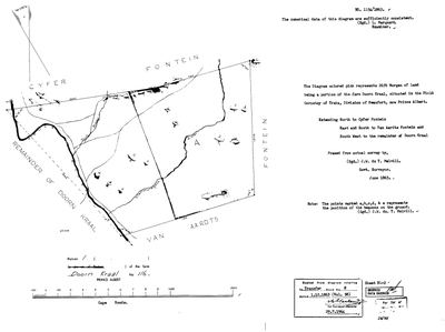 Surveyor-General diagram, 1154/1863, June 1863
SCAN305 116 1.jpg
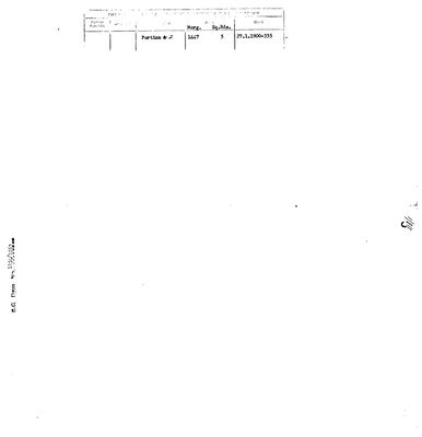 Diagram verso, 1154/1863 (verso), June 1863
SCAN306 116 1.jpg
Cadastre
Surveyor-General diagram index for this parcel
Surveyor-General diagram index for the whole farm — where the original survey of this ground sits.
Research notes
Surveyed by J.W. du T. MelvillM, June 1863; diagram 1154/1863, examined by L. MarquardM. The sheet is a Surveyor-General copy of 29 July 1964 taken from the diagram to Transfer Deed No. 8 of 1 December 1863 (Vol. 58). Bounded north by Cyfer Fontein, east and south by Van Aardts Fontein, south-west by the remainder of Doorn Kraal. The Tuin River and the watercourse Viermuisgat cross it.
[7 Aug 2026] PINNED to the cadastre on key W052C061000000000116000010. The diagram gives 2659 morgen = 2278 ha and the modern polygon measures 1190 ha, a difference of 48%.
[13 Aug 2026] Renamed to the one form this model uses for every portion - the portion's own name, then the parent farm, its number and the portion in brackets - so that a name is legible in a list, a search result and a map popup without the reader having to know which farm number is which. It read "Doorn Kraal No. 116 Portion 1" before. Nothing about the ground changed.
The research behind this page, kept separate from it: dated working notes, open questions, and what is not yet settled.
Open questions
-
Is diagram 1154/1863 the whole of Doorn Kraal rather than its Portion 1
priority 2 · LEAD-0140
DOC-0248, diagram 1154/1863, is filed in this model against Doorn Kraal Portion 1 and gives 2,659 morgen, 2,277.5 ha. Portion 1's polygon is 994.2 ha, so the diagram is 2.3 times its parcel. Its verso then records Portion 2 being cut off in 1900. Is 1154/1863 the whole farm's sheet, misfiled against a portion?
What would settle it The title block on the face of 1154/1863.
What the record is missing
-
“Van Aardts Fontein” is named as a neighbour 3 times and we hold no parcel for it
second order · B3 unheld-farm
3 separate surveys in this model put Van Aardts Fontein on the boundary of ground we do hold (PAR-000175, PAR-000176). It has no parcel of its own here, so nothing is known about who held it or when, while it borders farms at the centre of the project.
What would settle it The Surveyor-General's farm index for the registration division will give it a farm number and a diagram; the cadastre pull in `data/fetch_cadastre.py` then places it on the map.
-
“Remainder of Doorn Kraal” is named as a neighbour 2 times and we hold no parcel for it
third order · B3 unheld-farm
2 separate surveys in this model put Remainder of Doorn Kraal on the boundary of ground we do hold (PAR-000175, PAR-000176). It has no parcel of its own here, so nothing is known about who held it or when, while it borders farms at the centre of the project.
What would settle it The Surveyor-General's farm index for the registration division will give it a farm number and a diagram; the cadastre pull in `data/fetch_cadastre.py` then places it on the map.
-
Nobody is on record as ever having held this
third order · B8 never-held
Doorn Kraal No. 116 Ptn 1 is in the model and drawn on the map, and carries no ownership record of any kind, not a grant, not a transfer, not an occupation.
What would settle it The Surveyor-General's diagram for the farm number names the grantee and the date; the deed reference on it opens the transfer chain.
Found by breaks.py reading the model against itself, not written by hand,
each one is a shape of missing record, not a fault in the data.
The whole set is on the
questions page.