Part of Cyferfontein No. 115
Paardefontein (Cyferfontein No. 115 Ptn 2)
2/115 on the cadastre · on record 1916 · show on the map
The farm's own history, the grant, the original survey, sits on that page.
- Farm number
- No. 115
- Portion
- 2
- On the cadastre
- 2/115, portionregistered as CYFERFONTEIN
- District
- Prince Albert
- Extent, as the diagram states it
- 3286 morgen 200 square roods
- Modern surveyed area
- 2708.9 ha
The historic extent and the modern surveyed area are two separate measurements and are not presented here as confirming each other. The first is what a surveyor wrote on a diagram, usually in morgen. The second is what the modern cadastre draws.
Why this farm is here
A piece of a farm already in this model. 38 km from Klaarstroom.
- parcel Cut out of Cyferfontein No. 115
- border Shares a boundary with Klipgat No. 114 Klipgat No. 114
- border Shares a boundary with Cyferfontein No. 115 Cyferfontein No. 115
- document A document in the collection describes this ground DOC-0213
What the record holds, in order
- August 1916 document SG diagram 1640/1916
- undated boundary change subdivision: from Cyferfontein No. 115
Bordered by, as the diagram names them
- NW Wolve Kraal
- E, N & NE Cyferfontein Remainder (the middle of the Kouka River from X to Y)
- S Toornits Kraal
- S Lot No. 1 of Cyferfontein
- W Klipgat
Also bordered by, as the modern cadastre draws it
Ground that touches this farm on the Surveyor-General's current polygons and that none of the diagrams held here names. Derived from the geometry, not read off a document.
- N Wolwekraal No. 17
- NE Annex Boesmans Vlei No. 20
- SE Doorn Kraal No. 116
- SE Doorn Kraal No. 116 Ptn 1
- SW Voelfontein No. 213
- W Bontwater (Klipgat No. 114 Ptn 8)
Documents
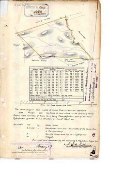 Surveyor-General diagram, 1640/1916, August 1916
10742947 112 2.pdf
Cadastre
Surveyor-General diagram index for this parcel
Surveyor-General diagram index for the whole farm — where the original survey of this ground sits.
Research notes
[3 Aug 2026, SRC-247] A NAMED PORTION - exactly what LEAD-0067 is about. The margin of the diagram reads "Portion 2 - Paardefontein (a portion of portion) of the farm Cyferfontein No. 115, PRINCE ALBERT", and the body: 3286 morgen 200 square roods in the Division of Prince Albert, FIELD CORNETCY OF TRAKA No. 3, "being Paardefontein, part of the Farm Cyferfontein granted to J.L. Strydom on the 15th April 1841". Surveyed and beaconed August 1916 by A.J. de VilliersM, Government Land Surveyor; deducted No. 2440, 19 October 1916. BOUNDED: NW by Wolve Kraal; E, N and NE by the Remainder, and from X to Y THE MIDDLE OF THE KOUKA RIVER IS THE BOUNDARY; S by Toornits Kraal and Lot No. 1 of Cyferfontein; W by Klipgat. THE TRANSFER, 22 May 1917, is stamped on the sheet: in favour of "M.E.C. Venter, born Swanepoel, married out of community to W.A. Venter" - a Venter and a Swanepoel, two of this project's families, holding ground between Klipgat and the Kouka. IDENTITY NOT ASSERTED, because 9 forbids matching on a name alone and this is initials. The model holds TWO women called Maria Elizabeth Catharina SwanepoelL alive in 1917 (PER-000581, b. 1888; PER-000711, b. 1884), and a Willem Adriaan VenterM (PER-000107) whose recorded floruit is 1879-1897, twenty years earlier. Plausible on all three counts and proved on none. LEAD-0070. No cadastral polygon: the extract holds only the parent 115 (7 346,5 ha), no portions. This portion is 3 286 1/3 morgen, about 2 815 ha, roughly 38% of the parent. [TO VERIFY]
[4 Aug 2026] plc_id was blank, so match_cadastre.py skipped this row entirely - it matches only within a registration division and a blank plc_id yields no division. Set to PLC-000001, Prince Albert.
*** [4 Aug 2026] sg_farm_key WAS 'NO-POLYGON' AND THAT WAS FALSE. *** The sentinel asserts that this ground has no cadastral counterpart, which is what 5 reserves it for - a vernacular name like Drooge Kloof that no diagram ever carried. This parcel is not that: the Surveyor-General publishes its polygon under the exact key its own farm and portion number imply, and it was sitting in geo/prince_albert_*.geojson the whole time. The sentinel is cleared so match_cadastre.py can do its job. Reasoning from absence, stated as fact - the same mistake as Drooge Kloof and Modderdrift, both recorded in 5a.
The research behind this page, kept separate from it: dated working notes, open questions, and what is not yet settled.
Open questions
-
Who are the M.E.C. Venter born Swanepoel and the W.A. Venter who took Paardefontein in 1917?
priority 2 · LEAD-0070
Which Maria Elizabeth Catharina SwanepoelL married which Willem Adriaan VenterM, and are they the pair named on the 1917 transfer of Paardefontein?
What would settle it Full given names on the transfer deed, or a marriage naming a Willem Adriaan VenterM and a Maria Elizabeth Catharina SwanepoelL.
What the record is missing
-
“Wolve Kraal” is named as a neighbour 2 times and we hold no parcel for it
third order · B3 unheld-farm
2 separate surveys in this model put Wolve Kraal on the boundary of ground we do hold (PAR-000153, PAR-000182). It has no parcel of its own here, so nothing is known about who held it or when, while it borders farms at the centre of the project.
What would settle it The Surveyor-General's farm index for the registration division will give it a farm number and a diagram; the cadastre pull in `data/fetch_cadastre.py` then places it on the map.
-
Nobody is on record as ever having held this
third order · B8 never-held
Paardefontein (Cyferfontein No. 115 Ptn 2) is in the model and drawn on the map, and carries no ownership record of any kind, not a grant, not a transfer, not an occupation.
What would settle it The Surveyor-General's diagram for the farm number names the grantee and the date; the deed reference on it opens the transfer chain.
Found by breaks.py reading the model against itself, not written by hand,
each one is a shape of missing record, not a fault in the data.
The whole set is on the
questions page.