Uitnood No. 147 (Loan Farm Uit-Nood)
· on record 1833 · show on the map
- Farm number
- No. 147
- District
- Willowmore
- Extent, as the diagram states it
- 6,376 morgen including the annexed Government ground
- Modern surveyed area
- 4725.2 ha
The historic extent and the modern surveyed area are two separate measurements and are not presented here as confirming each other. The first is what a surveyor wrote on a diagram, usually in morgen. The second is what the modern cadastre draws.
Why this farm is here
Petrus van Veuren Senior held it, and no kinship to the Oosthuizen, Marincowitz or Van der Merwe lines is recorded, this ground entered through the land, not the family. 36 km from Klaarstroom.
- border Shares a boundary with Haggas No. 145 Haggas No. 145
- border Shares a boundary with Vondeling No. 139 Vondeling No. 139
- document A document in the collection describes this ground DOC-0155
- document A document in the collection describes this ground DOC-0156
What the record holds, in order
-
August 1833
document
SG diagram B 358/1833
Bf.W.Q.5-32
- August 1833 document SG diagram B 358/1833 (reverse)
-
about 1833
ownership
Petrus van Veuren Senior
quitrent · grant · confidence high
Bordered by, as the diagram names them
- N the Loan Farm Haggis
- S Zwarte Berg
- E the Vondeling
- W Haggis
Buried on this ground
- Uitnood 147 farm cemetery, Swartberge 2 graves recorded, 2 identified in this project
The burials also appear on this farm's timeline above, each at its own date.
Also bordered by, as the modern cadastre draws it
Ground that touches this farm on the Surveyor-General's current polygons and that none of the diagrams held here names. Derived from the geometry, not read off a document.
Documents
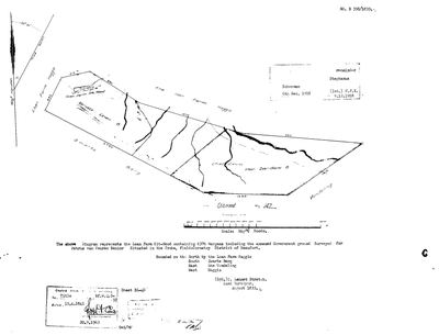 Surveyor-General diagram, B 358/1833, August 1833
SCAN923.jpg
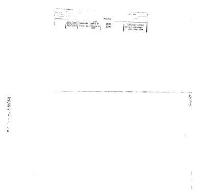 Surveyor-General diagram, B 358/1833 (reverse), August 1833
SCAN924.jpg
Research notes
[1 Aug 2026 inbox] Loan farm, Traka field cornetcy, District of Beaufort. SG Dgm B 358/1833 (DOC-0155), surveyed by C. LENNOX STRETCH, AUGUST 1833, for PETRUS VAN VEUREN SENIOR. Title Bf.W.Q.5-32 dated 15 APRIL 1841, re-stamped 20.9.1963. Bounded N by the Loan Farm Haggis, S by the Zwarte Berg, E by the Vondeling, W by Haggis. The sheet names 'Geruste Leven B', 'Cheridauw voor Zeeridouw B' and an arable of 10 morgen. TWO CONNECTIONS THIS MAKES. (1) THE 15 APRIL 1841 GRANT DAY: Uitnood's title is Bf.W.Q.5-32, on the same day as Oorlogs Kloof's Bf.W.Q.5-30, Haggas's Bf.W.Q.5-31, the Hitge title B.W.Q.5-18 and Reim Hoogte's B.F.W.Q.5-10. The numbers are now consecutive across four farms we hold, which strengthens the mass-grant reading in S007 rather than the coincidence reading. (2) THE VAN VEURENS: Oorlogs Kloof No. 172 (PAR-000066, DOC-0073) was surveyed the same month by the same surveyor for LUCAS VAN VEUREN, recorded on that form as 'P. Zoon'. Petrus van Veuren SeniorH holding the adjoining Uitnood reads as the P. that 'P. Zoon' names, so father and son took up neighbouring ground in the Traka in August 1833. That is an inference from two diagrams, not a stated relationship, and it is [TO VERIFY] against a death notice or an estate paper. See LEAD-0054. PORTIONS, from the reverse (DOC-0156): Geruste Leven B = Portion 147/1, 1,885 morgen, Dgm 666/1910, registered 1910-135-8686; Voor Zeeridouw B = Portion 147/3, 3,190 morgen, Dgm 345/1917, registered 1921-129-7798 (an earlier 27.9.1918-6810 entry is struck through). 1918 endorsements name Schoeman (6 Dec 1918) and a 'remainder Stephanus'. NO GEOMETRY: not yet matched to the cadastre. [1 Aug 2026]
[1 Aug 2026] REGISTRATION DIVISION CORRECTED to Willowmore (PLC-000037). The 1833 diagram says "Traka Field Cornetcy, District of Beaufort", and the national cadastre puts UITNOOD 147 in C0830000 WILLOWMORE, Eastern Cape. Exactly the Haggas situation: the 1830s Beaufort District was vast and was later cut, and the provincial boundary now runs through this ward. The ward is still Traka, which is ours.
The research behind this page, kept separate from it: dated working notes, open questions, and what is not yet settled.
Open questions
-
Petrus van Veuren Senior and Lucas van Veuren "P. Zoon": father and son on adjoining ground?
priority 2 · LEAD-0054
Was Lucas van VeurenM of Oorlogs Kloof No. 172 the son of Petrus van Veuren SeniorH of Uitnood No. 147?
What would settle it A death notice or estate account naming Lucas as a son of Petrus, or a baptism entry giving Lucas a father Petrus. Either would turn an initial into a relationship.
-
Six parcels whose surveyed extent is far from their polygon with no reason recorded
priority 2 · LEAD-0093
For each, is the extent mistyped, or did ground leave the farm without a note?
What would settle it The deduction table. It lists portion, name, extent, diagram and deed on one line.
What the record is missing
-
The record stops in 1833 and never resumes
second order · B2 trail-ends
Uitnood No. 147 (Loan Farm Uit-Nood) was worked as far as 1833~, with Petrus van Veuren SeniorH the last owner on record. 193 years follow with nothing. Who held it after that, and is it still one farm?
What would settle it The current title deed traced backwards, each transfer names the one before it, or the Surveyor-General's subdivision diagrams, which are what usually explain a farm going quiet.
Found by breaks.py reading the model against itself, not written by hand,
each one is a shape of missing record, not a fault in the data.
The whole set is on the
questions page.