De Vlei No. 176
176 on the cadastre · on record 1921 · show on the map
- Farm number
- No. 176
- On the cadastre
- 176, whole farmregistered as FARM
- District
- Prince Albert
- Extent, as the diagram states it
- 2722 morgen 78 sq roods; 2331,5914 hektaar (metric endorsement)
- Modern surveyed area
- 2319.6 ha
The historic extent and the modern surveyed area are two separate measurements and are not presented here as confirming each other. The first is what a surveyor wrote on a diagram, usually in morgen. The second is what the modern cadastre draws.
Why this farm is here
Described by a document in this collection. 18 km from Klaarstroom.
- document A document in the collection describes this ground DOC-0182
What the record holds, in order
- April 1921 document SG diagram 2673/1921
Also bordered by, as the modern cadastre draws it
Ground that touches this farm on the Surveyor-General's current polygons and that none of the diagrams held here names. Derived from the geometry, not read off a document.
- N Oorlogs Kloof No. 175 (1940 consolidation)
- E Haggas No. 145
- E Uitnood No. 147 (Loan Farm Uit-Nood)
- W Witberg No. 180
- NW Oorlogs Kloof No. 172 (Roode Els Bosch and Oorlogs Kloof)
Documents
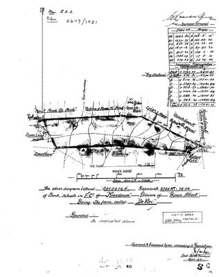 Surveyor-General diagram, 2673/1921, April 1921
10069777 176 part 0.jpg
Cadastre
Surveyor-General diagram index for this parcel
Research notes
[3 Aug 2026, SRC-216] Surveyed April 1921 in the field cornetcy of KREEDOUW. The diagram carries both the original 2722 morgen 78 sq roods and a later metric endorsement of 2331,5914 ha; those agree to within 0,1% at the morgen factor, so the endorsement is a conversion and not a resurvey. It sits on the Zwartberg side, bounded by Roode Els Bosch, HAGAS, UITNOOD, Kolberg and Crown Land - a different corner of the division from the Traka ward this project mostly follows, and it is here because it adjoins farms already drawn.
The research behind this page, kept separate from it: dated working notes, open questions, and what is not yet settled.
What the record is missing
-
Nobody is on record as ever having held this
third order · B8 never-held
De Vlei No. 176 is in the model and drawn on the map, and carries no ownership record of any kind, not a grant, not a transfer, not an occupation.
What would settle it The Surveyor-General's diagram for the farm number names the grantee and the date; the deed reference on it opens the transfer chain.
Found by breaks.py reading the model against itself, not written by hand,
each one is a shape of missing record, not a fault in the data.
The whole set is on the
questions page.