Rietkuil Nr. 119 (Kouka)
119 op die kadaster · op rekord 1833–1841 · wys op die kaart
- Plaasnommer
- Nr. 119
- Op die kadaster
- 119, heel plaasgeregistreer as RIETKUIL
- Distrik
- Prince Albert
- Grootte, soos die kaart dit stel
- 14 379 morgen (loan farm plus annexed Government ground)
- Moderne opgemete oppervlakte
- 12825.6 ha
Die historiese grootte en die moderne opgemete oppervlakte is twee aparte metings en word hier nie aangebied asof hulle mekaar bevestig nie. Die eerste is wat 'n landmeter op 'n kaart geskryf het, gewoonlik in morg. Die tweede is wat die moderne kadaster teken.
Waarom hierdie plaas hier is
Pieter Johannes Swanepoel (b6c5d7) het hier gewoon. Verbind aan die Oosthuizen, Marincowitz of Van der Merwe-lyne DEUR HUWELIK, nie deur bloed nie, 5 treë op die kortste pad. 42 km van Klaarstroom.
- Pieter Johannes Swanepoel (b6c5d7)
- getroud met Johanna Jacomina Petronella Catharina Venter
- kind van Maria Catharina Venter
- kind van Jan Louis Venter
- ouer van Adriana Cecilia Venter
- ouer van Johannes Adriaan Oosthuizen
Elke tree is 'n aangetekende afkoms of huwelik in hierdie model, en die kortste een wat die rekord ondersteun; volg die name om dit na te gaan.
- storie 'n Geskrewe geskiedenis speel op hierdie grond af The fifteenth of April, 1841
- storie 'n Geskrewe geskiedenis noem hierdie grond Cut, and then stitched
- grens Deel 'n grens met Van Aardsfontein Nr. 109 Van Aardsfontein Nr. 109
- grens Deel 'n grens met Klipgat Nr. 114 Klipgat Nr. 114
- …en nog 1, volledig gelys verder af op hierdie bladsy.
Stories
- about this farm
Die vyftiende April 1841
Een landmeter meet die Koup twee seisoene lank op. Agt jaar later, op een dag, maak die Kroon 'n dosyn leningsplase titelgrond - en die distrik se kaart lê vir 'n eeu vas.
- mentions this farm
Gesny, en toe weer aanmekaargewerk
Hierdie projek het 124 grensdade op rekord: 96 onderverdelings en 20 konsolidasies. Gesorteer op datum vertel hulle een storie met 'n draaipunt. Die distrik het honderd-en-vyftig jaar lank net gesny; van 1970 af word net weer aanmekaargewerk.
Wat die rekord hou, in volgorde
-
September 1833
document
SG diagram 361/1833
Bf.W.Q. 3-35
-
1837
lived here
Pieter Johannes Swanepoel (b6c5d7) (13 Februarie 1799–26 Maart 1885)
farming
-
1841-04-15 to 1885-03-26
ownership
Pieter Johannes Swanepoel (b6c5d7) (13 Februarie 1799–26 Maart 1885)
quitrent · grant · confidence high
Begrens deur, soos die kaart hulle noem
Ook begrens deur, soos die moderne kadaster dit teken
Grond wat aan hierdie plaas raak op die Landmeter-generaal se huidige poligone en wat geen kaart wat hier gehou word, noem nie. Afgelei uit die meetkunde, nie van 'n dokument afgelees nie.
- N Swartgrond (Van Aardsfontein Nr. 109 Gdlt 3)
- S Minnies Kraal Nr. 112 Gdlt 2
- S Schilpads Vlakte Nr. 111
- SW Aschkop (Klipgat Nr. 114 Gdlt 10)
- SW Minnies Kraal Nr. 112
- SW Askop (Minnies Kraal Nr. 112 Gdlt 1)
- W Klipgat Nr. 114
- W Meriba (Van Aardsfontein Nr. 109 Gdlt 5)
- W Van Aardsfontein Nr. 109 Gdlt 6
- W Van Aardsfontein Nr. 109 Gdlt 7
Dokumente
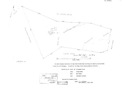 Landmeter-generaal-kaart, 361/1833, September 1833
10N1PP01 119 0.jpg
Kadaster
Die Landmeter-generaal se kaartindeks vir hierdie perseel
Navorsingsnotas
[SRC-072] On the Kouka River in the field cornetcy of Traka. Granted on perpetual quitrent 15 APRIL 1841 to Pieter Johannes SwanepoelL (PER-000083), 14,379 morgen, then in the district of Beaufort West - AK: Beaufort West Quits Vol 5 Fol 35. THE EIGHTH FARM NOW DOCUMENTED ON THAT ONE DAY (see STO-0007). Occupied from at least Aug 1837, seven years before the grant. Kouka/Kauka is Khoi for Buffalo River. The thesis gives the farm number as 118 in ch.4 and 119 in ch.5 [TO VERIFY]. Neighbour: Van Aardsfontein No. 109 (PAR-000064).
[3 Aug 2026, SRC-230] ITS 1833 DIAGRAM. Dgm 361/1833 by C. L. Stretch: the LOAN FARM DE RIET KUYL with annexed Government ground, 14 379 morgen, in the TRAKA field cornetcy of the BEAUFORT district, SURVEYED FOR HERMANUS STEIN. Titled Bf.W.Q. 3-35 on 15 APRIL 1841 - the day of STO-0007. Bounded N by Van Aardes Baken, S by Vleige Kraal, E by Muis Kraal, W by Government ground; the Kouka and Scheffers-gate rivers cross it. "4 Morgen arable land" is written across the middle. *** A NUMBER QUESTION, NOT RESOLVED HERE. *** The diagram's title block reads "THE FARM Riet Kuyl No. 118" and this row follows it - but the modern cadastre publishes RIETKUIL as FARM 119, at 12 867,6 ha, and the diagram itself carries a pencilled "Vide farm 119" beside the Government ground on its western side. Frans's filename hint also read 119. So either the farm was renumbered, or the annexed Government ground became 119 while the loan farm kept 118, or 118 and 119 are neighbours. This is the same class of question as Rietfontein/Minnies Kraal and it is not to be settled by picking one. [TO VERIFY]
[3 Aug 2026, SRC-225] A MECHANISM FOR THE 118/119 QUESTION. The verso of the 1886 Klaarstroom diagram shows three portions whose labels were STRUCK OUT AND REPLACED with new numbers decades later - "Lot C" to 178/29, "Ptn. 4" to 178/32, "Ptn. 5" to 178/33. Renumbering on the face of a sheet is evidently ordinary practice in this division, which makes "the farm was renumbered 118 to 119" a live possibility rather than a guess. Still not established.
[5 Aug 2026] FARM NUMBER SETTLED: 119, not 118. The thesis (SRC-072) gave 118 in chapter 4 and 119 in chapter 5, and the row has carried that as [TO VERIFY] since. The Prince Albert cadastre decides it two ways: there is NO FARM 118 in the division at all, and farm 119 is named RIETKUIL and carries eight portions. The extent agrees as well - the 1833 loan farm with its annexed Government ground is 14,379 morgen, about 12,316 ha, against a whole-farm polygon of 12,834 ha, within 4%. The farm is now pinned.
[8 Aug 2026, from SG 361/1833 read for the first time] Stretch surveyed this in September 1833 as 'the Loan Farm DE RIET KUYL including Government ground annexed', 14 379 morgen, in the TRAKA FIELD CORNETCY of the Beaufort district, 'SURVEYED FOR HERMANUS STEIN' [PER-001603]. Four morgen were arable. The Kouka River, the Schepperegate River, Commando Kraal and Eve's Kraal are all drawn and named on the figure. The 15 April 1841 title Bf.W.Q.3-35 grants it to Pieter Johannes SwanepoelL, so the loan place changed hands between the survey and the grant and this project does not know how. [TO VERIFY]
Werknotas, hier gewys omdat dit 'n private navorsingsbou is.
Die werksnotas op hierdie werf word in Engels gehou en word nie vertaal nie. Hulle verander met elke navorsingsessie, en 'n vertaling sou uit pas raak met die oorspronklike. Alles anders — die stories, die getranskribeerde dokumente en die koppelvlak — is in Afrikaans.
Oop vrae
-
Why 15 April 1841? The project's headline question has never been a lead
prioriteit 1 · LEAD-0091
Was the day a batch signature clearing a quitrent conversion backlog, a settlement scheme, or routine administration?
Wat dit sou uitmaak The register. If many farms across the district share the date and the underlying entries are spread over years, it is a signing session and the question is answered.
Wat die rekord kortkom
-
The record stops in 1885 and never resumes
second order · B2 trail-ends
Rietkuil Nr. 119 (Kouka) was worked as far as 1885-03-26, with Pieter Johannes SwanepoelL (b6c5d7) the last owner on record. 141 years follow with nothing. Who held it after that, and is it still one farm?
What would settle it The current title deed traced backwards, each transfer names the one before it, or the Surveyor-General's subdivision diagrams, which are what usually explain a farm going quiet.
Found by breaks.py reading the model against itself, not written by hand,
each one is a shape of missing record, not a fault in the data.
The whole set is on the
questions page.