Klipgat Nr. 114
114 op die kadaster · op rekord 1910–1911 · wys op die kaart
- Plaasnommer
- Nr. 114
- Op die kadaster
- 114, heel plaasgeregistreer as KLIPGAT
- Distrik
- Prince Albert
- Grootte, soos die kaart dit stel
- 21,379 morgen 520 sq roods
- Moderne opgemete oppervlakte
- 17355.9 ha
Die historiese grootte en die moderne opgemete oppervlakte is twee aparte metings en word hier nie aangebied asof hulle mekaar bevestig nie. Die eerste is wat 'n landmeter op 'n kaart geskryf het, gewoonlik in morg. Die tweede is wat die moderne kadaster teken.
Waarom hierdie plaas hier is
Louis Daniel Francois van Zyl het dit gehou, en geen verwantskap met die Oosthuizen, Marincowitz of Van der Merwe-lyne is aangeteken nie — hierdie grond het deur die grond ingekom, nie deur die familie nie. 30 km van Klaarstroom.
- perseel Grond uit hierdie plaas gesny: Zoutwater (Klipgat Nr. 114 Gdlt 1)
- perseel Grond uit hierdie plaas gesny: Klipgat A (Klipgat Nr. 114 Gdlt 2)
- perseel Grond uit hierdie plaas gesny: Lot A (Klipgat Nr. 114 Gdlt 3)
- perseel Grond uit hierdie plaas gesny: Rivervale (Klipgat Nr. 114 Gdlt 4)
- …en nog 2, volledig gelys verder af op hierdie bladsy.
Wat die rekord hou, in volgorde
-
September 1910
document
SG diagram 1200/1911
D/G P.A.Q 6-7
- 1911 document SG diagram verso 1200/1911 (verso)
-
voor 1911 to 1911-09-24
ownership
Louis Daniel Francois van Zyl (1832–1900)
quitrent · estate · confidence high
-
1911-09-24 to 1916
ownership
Louis Daniel Francois van Zyl (1832–1900)
quitrent · amended title · confidence high
- undated boundary change subdivision: becomes Zoutwater (Klipgat Nr. 114 Gdlt 1)
- undated boundary change subdivision: becomes Klipgat A (Klipgat Nr. 114 Gdlt 2)
- undated boundary change subdivision: becomes Lot A (Klipgat Nr. 114 Gdlt 3)
- undated boundary change subdivision: becomes Rivervale (Klipgat Nr. 114 Gdlt 4)
- undated boundary change subdivision: becomes Bulhouwer (Klipgat Nr. 114 Gdlt 5)
- undated boundary change subdivision: becomes Nieuwe Dam (Klipgat Nr. 114 Gdlt 6)
- undated boundary change subdivision: becomes Kalkgat (Klipgat Nr. 114 Gdlt 7)
- undated boundary change subdivision: becomes Bontwater (Klipgat Nr. 114 Gdlt 8)
- undated boundary change subdivision: becomes Quaggas Poel (Klipgat Nr. 114 Gdlt 9)
- undated boundary change subdivision: becomes Aschkop (Klipgat Nr. 114 Gdlt 10)
Grond uit hierdie plaas gesny
- Zoutwater (Klipgat Nr. 114 Gdlt 1) 1/114 · 1822.9 ha
- Klipgat A (Klipgat Nr. 114 Gdlt 2) 2/114 · 1830.1 ha
- Lot A (Klipgat Nr. 114 Gdlt 3) 3/114 · 9.3 ha
- Rivervale (Klipgat Nr. 114 Gdlt 4) 4/114 · 961.5 ha
- Bulhouwer (Klipgat Nr. 114 Gdlt 5)
- Nieuwe Dam (Klipgat Nr. 114 Gdlt 6) 6/114 · 1825.8 ha
- Kalkgat (Klipgat Nr. 114 Gdlt 7) 7/114 · 1837.5 ha
- Bontwater (Klipgat Nr. 114 Gdlt 8) 8/114 · 1845.6 ha
- Quaggas Poel (Klipgat Nr. 114 Gdlt 9)
- Aschkop (Klipgat Nr. 114 Gdlt 10) 10/114 · 1853.7 ha
Begrens deur, soos die kaart hulle noem
- N Wit Poortje (A-C)
- N Doorn Kraal (O-P)
- NE Swanepoels Aanleg (Q-A)
- NE Rietkuil (M-N)
- E Doorn Kraal (P-Q)
- E Remainder Van Aardens Fontein (N-O)
- SE Schilpads Vlakte (L-M)
- S Nieuwjaarsfontein (I-L)
- SW Kopjes Kraal (H-I)
- W Rondable (H-G)
- W Rhemhoogte (F-G)
- W Modderdrift and Rhemhoogte (D-F)
- NW Portion Zeekoe Gat (C-D)
Ook begrens deur, soos die moderne kadaster dit teken
Grond wat aan hierdie plaas raak op die Landmeter-generaal se huidige poligone en wat geen kaart wat hier gehou word, noem nie. Afgelei uit die meetkunde, nie van 'n dokument afgelees nie.
- N Wolwekraal Nr. 17
- N Voelfontein Nr. 213
- NE Cyferfontein Nr. 115
- NE Paardefontein (Cyferfontein Nr. 115 Gdlt 2)
- NE Doorn Kraal Nr. 116
- E Rivervale (Klipgat Nr. 114 Gdlt 4)
- E Nieuwe Dam (Klipgat Nr. 114 Gdlt 6)
- E Van Aardsfontein Nr. 109 Gdlt 6
- E Van Aardsfontein Nr. 109 Gdlt 7
- SE Aschkop (Klipgat Nr. 114 Gdlt 10)
- SE Minnies Kraal Nr. 112
- SE Minnies Kraal Nr. 112 Gdlt 2
- SE Askop (Minnies Kraal Nr. 112 Gdlt 1)
- SE Nuwejaarsfontein (Minnies Kraal Nr. 112 Gdlt 7)
- SE Klein Minnieskraal (Minnies Kraal Nr. 112 Gdlt 8)
- S Kromrivier (Kopjes Kraal Nr. 123 Gdlt 1)
- S Brand Kraal (Rondabel Nr. 124 Gdlt 3)
- S Rondawel (Rondabel Nr. 124 Gdlt 1)
- SW Kalkgat (Klipgat Nr. 114 Gdlt 7)
- SW Rhemhoogte Nr. 125 Gdlt 8
- SW Swartskraal (Rhemhoogte Nr. 125 Gdlt 6)
- W Annex Modderdrift (Rhemhoogte Nr. 125 Gdlt 3)
- W Modderdrift Nr. 106 Gdlt 1
- W Modderdrift Nr. 106 Gdlt 4
- W Modderdrift Nr. 239
- NW Zoutwater (Klipgat Nr. 114 Gdlt 1)
- NW Bontwater (Klipgat Nr. 114 Gdlt 8)
- NW Wit Poortje Nr. 16
Dokumente
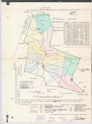 Landmeter-generaal-kaart, 1200/1911, September 1910
11369058 klipgat.pdf
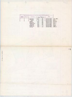 Kaart se keersy, 1200/1911 (verso), 1911
11369059.PDF
Kadaster
Die Landmeter-generaal se kaartindeks vir hierdie perseel
Navorsingsnotas
[1 Aug 2026 inbox] SG Dgm 1200/1911, D/G P.A.Q 6-7 (DOC-0158), surveyed Sept 1910 by A.J. de VilliersM, Govt Surveyor, and certified for the Surveyor-General at Cape Town on 24 Sept 1911. The field cornetcy is written as TRAKA, struck through, and amended by hand to GOUPH No. 3, which is the same renaming visible on the 1935 Vrolykheid portion diagrams where Traka is corrected to Kredouw. Division of Prince Albert. THE TITLE: "this diagram belongs to the amended title deed this day issued in favour of the Estate of the late LUCAS DANIEL FROMON VAN ZYL", under Act 9 of 1879. Beacons and boundaries established vide BA 025/1911. A note on the sheet records "Portion Zeekoe Gat Transferred to P.J. Swanepoel 30/7/1857". WHY THIS FARM MATTERS TO THIS PROJECT: its boundary list names RONDABLE (H-G), MODDERDRIFT and RHEMHOOGTE (D-F), Rhemhoogte again (F-G), KOPJES KRAAL (H-I and I-L), and Portion Zeekoe Gat (C-D). Those are five farms already in the model, so this one sheet independently corroborates the relative positions of Rondabel No. 124, Modderdrift No. 106 (added the same day from its own diagrams), Rhemhoogte No. 125 and Kopjes Kraal No. 123. It also names VAN AARDENS FONTEIN on the east (N-O), which answers why Van Aardsfontein No. 109 sat on the map with no neighbour beside it: Klipgat is the neighbour, and it was not in the model. Full boundary list: N A-C Wit Poortje; N O-P Doorn Kraal; NE Q-A Swanepoels Aanleg ("Watervals Kraal" struck through); NE M-N Rietkuil; E P-Q Doorn Kraal; E N-O Remainder Van Aardens Fontein; SE L-M Schilpads Vlakte; SW H-I Kopjes Kraal; S I-L Schilpads Vlakte, Nieuwjaarsfontein, Kopjes Kraal; H-G Rondable; D-F Modderdrift and Rhemhoogte; F-G Rhemhoogte; C-D Portion Zeekoe Gat. The sheet carries a full co-ordinate table in Cape Roods for beacons A to Q, and Bayley's Trig Station at +1314.20 +2439.74. NOT georeferenced by eye, per 9. EVT-000110, the August 1913 meeting of Zeekoegat district farmers on the fencing act, was held on Klipgat and now has a parcel to hang on. [1 Aug 2026]
*** [3 Aug 2026, SRC-227/SRC-228] KLIPGAT WAS A VAN ZYL FARM, and its subdivision was an estate being divided. *** Both portion diagrams now held say the ground was GRANTED TO THE ESTATE OF THE LATE LOUIS DANIEL FRANCOIS VAN ZYL ON 9 SEPTEMBER 1911. A.I. de VilliersM surveyed the portions in December 1911, they were deducted in February 1913, and they were transferred out on 15 NOVEMBER 1916 ON CONSECUTIVE DEEDS: 8820 Zout Water to Christian H. van Zyl, 8821 Klipgat A to Jacobus J.P. van Zyl, and PAR-000112 carries 8830 for Quaggas Poel at the far end of the same run. Ten near-equal pieces, one estate, one day. THAT MATTERS BEYOND KLIPGAT: van Zyl is one of the surnames this project follows (STO-0018), and the Klipgat portions border Modderdrift, Rhemhoogte and Rondabel. [TO VERIFY which van Zyls - the given names are recorded, the identities are not]
[9 Aug 2026] TWO CONFLICTS BETWEEN THIS FARM'S OWN SHEETS. (1) THE DEAD MAN'S NAME. The 1911 whole-farm sheet, DOC-0158, issues the amended title to "the Estate of the late LUCAS DANIEL FROMON VAN ZYL". The portion sheets of the following year, DOC-0193 to DOC-0195, all read "the late LOUIS DANIEL FRANCOIS VAN ZYL". Same initials, same estate, same subdivision, months apart. 5a: both spellings stay as written and neither is tidied into the other. Which the man used is not settled here. (2) THE ZEEKOE GAT DATE, TEN YEARS APART. DOC-0158's marginal note reads "Portion Zeekoe Gat Transferred to P.J. Swanepoel 30/7/1857"; DOC-0193's boundary statement reads "30.7.1867". One of the two is a misread 5 or 6, and this project holds no third sheet to break the tie. [TO VERIFY]
[9 Aug 2026] AND ZEEKOE GAT ITSELF IS NOT IN THIS MODEL. It is named as a BOUNDARY of Klipgat on both sheets, so it was cut off this farm decades before the 1911 estate division and became an outside neighbour. The cadastre carries a 15/114 that appears on no sheet here (noted on PAR-000104), and farm 114's portions currently fall about 10% short of the whole farm in checks.py. Whether those three facts are one fact is LEAD-0138.
[9 Aug 2026] THE DIVISION WAS ELEVEN SHARES, NOT TEN, AND THE ARITHMETIC SAYS SO EXACTLY. The ten portions this model holds carry, on their own extent figures, 19,245.3767 morgen. The 1911 parent is 21,379 morgen 520 roods. THE DIFFERENCE IS 2,134.49 MORGEN, WHICH IS 0.998 OF ONE STANDARD SHARE - the nine large portions run 2,134 to 2,138 morgen each. So one whole share of this farm is not in this model, and its size is known to within four morgen. That corroborates the 15/114 the cadastre carries and no sheet here shows, already noted on PAR-000104.
AND IT NARROWS LEAD-0138. That lead predicted 15/114 was the old ZEEKOE GAT portion. This makes that unlikely: Zeekoe Gat was transferred to P.J. Swanepoel in 1857 or 1867, decades before the 1911 survey, so it lies OUTSIDE the 21,379 morgen this parent measures. The missing piece is a near-equal share of the 1911 division, which is a different thing. Zeekoe Gat is still unaccounted for and still worth finding; it is just not this.
THE MODERN POLYGON IS SMALLER THAN THE 1911 FARM. The cadastre gives farm 114 as 17,355.9 ha against the parent's 21,379 morgen 520 roods = 18,312.5 ha, 5.2% less. The same Remainder-shaped question as Klaarstroom No. 178, Rhemhoogte No. 125 and Doorn Kraal No. 116. [TO VERIFY]
Werknotas, hier gewys omdat dit 'n private navorsingsbou is.
Die werksnotas op hierdie werf word in Engels gehou en word nie vertaal nie. Hulle verander met elke navorsingsessie, en 'n vertaling sou uit pas raak met die oorspronklike. Alles anders — die stories, die getranskribeerde dokumente en die koppelvlak — is in Afrikaans.
Oop vrae
-
Three van Zyl landholdings in this district, and whether they connect
prioriteit 1 · LEAD-0057
Are Casper van ZylMe Senior of Modderdrift No. 106 (1833), Lucas Daniel Fromon van Zyl of Klipgat No. 114 (d. by 1911), and the Brandfort van Zyls of S018 one family?
Wat dit sou uitmaak A death notice or estate account that puts two of these three men in one descent. Ten named heirs from the 1916 deeds would be the fastest route, because ten names are far easier to match against the tree than one.
-
The estate of Louis Daniel Francois van Zyl (d. 1900), who held Klipgat No. 114
prioriteit 1 · LEAD-0096
Does his death notice name Christiaan Hendrik and Jacobus Johannes Petrus among the heirs, and Klipgat among the estate property?
Wat dit sou uitmaak A Cape death notice names the surviving spouse and every child by name, and the estate file lists the property. Both halves in one document.
-
Zeekoe Gat, cut off Klipgat before the estate division, is in no row here
prioriteit 2 · LEAD-0138
Both of Klipgat No. 114's own sheets name "Portion Zeekoe Gat, transferred to P.J. Swanepoel" as a BOUNDARY of the farm - so it was cut off Klipgat decades before the 1911 estate division and became an outside neighbour. This project holds no parcel for it. What is it, and is it the same thing as the 15/114 the modern cadastre carries and no sheet here shows? The two sheets also disagree on the date by ten years: DOC-0158 reads 30/7/1857 and DOC-0193 reads 30.7.1867.
Wat dit sou uitmaak The diagram for 15/114, or the Swanepoel transfer.
Wat die rekord kortkom
-
The record stops in 1916 and never resumes
second order · B2 trail-ends
Klipgat Nr. 114 was worked as far as 1916, with Louis Daniel Francois van ZylH the last owner on record. 110 years follow with nothing. Who held it after that, and is it still one farm?
What would settle it The current title deed traced backwards, each transfer names the one before it, or the Surveyor-General's subdivision diagrams, which are what usually explain a farm going quiet.
Found by breaks.py reading the model against itself, not written by hand,
each one is a shape of missing record, not a fault in the data.
The whole set is on the
questions page.