Vrolikheid
177 op die kadaster · op rekord 1833–1934 · wys op die kaart
- Plaasnommer
- Nr. 177
- Op die kadaster
- 177, heel plaasgeregistreer as VROLYKHEID
- Distrik
- Prince Albert
- Moderne opgemete oppervlakte
- 5664.6 ha
Waarom hierdie plaas hier is
Jacobus Johannes Oosthuisen (Almero's son) het dit gehou. 8 km van Klaarstroom.
Jacobus Johannes Oosthuisen (Almero's son) is regstreeks op hierdie grond aangeteken. Geen spoor nodig nie.
- storie 'n Geskrewe geskiedenis speel op hierdie grond af The fifteenth of April, 1841
- storie 'n Geskrewe geskiedenis noem hierdie grond Middelwater No. 169: a farm history
- storie 'n Geskrewe geskiedenis speel op hierdie grond af Vrolykheid No. 177: a farm history
- storie 'n Geskrewe geskiedenis noem hierdie grond De Claar Stroom: the farm the town stands on
- …en nog 2, volledig gelys verder af op hierdie bladsy.
Stories
- about this farm
Die vyftiende April 1841
Een landmeter meet die Koup twee seisoene lank op. Agt jaar later, op een dag, maak die Kroon 'n dosyn leningsplase titelgrond - en die distrik se kaart lê vir 'n eeu vas.
- mentions this farm
Middelwater Nr. 169: 'n plaasgeskiedenis
Van 'n leningsplaas in die Swartberg tot agt kadastrale persele: die gedokumenteerde geskiedenis van Middelwater Nr. 169 - Stretch se opmeting van 1833 vir Okert Oosthuizen, die toekenningsdag van 1841, die heropmeting van 1883 en die kwitrent van 1884 aan J.D.J. Oosthuysen 'and another', die gedeeltes wat afgesny is vir 'n fontein genaamd Vaste Water en 'n plek genaamd Avondrust, en die kraglynopmeting van 1990 waarvan die koördinate die plaas uiteindelik op 'n kaart gesit het.
- about this farm
Vrolykheid Nr. 177: 'n plaasgeskiedenis
Die plaas waar die papier en die mense verskil. Stretch se opmeting van 1833 dra al klaar die name van gedeeltes wat eers 'n eeu later gesny word; twee titels gaan op een dag in 1841 uit, een aan 'n Oosthuisen en een aan 'n 'N. Hitge' wie se akte deur vier latere gedeeltes aangehaal word; 'n Triëstenaar trou in 1844 met 'n Hitge en hou die plaas toe hy in 1890 sterf; en 'n sterfkennis sit die Hitges uiteindelik self op die grond.
- mentions this farm
De Claar Stroom: die plaas waarop die dorp staan
Die leningsplaas De Claar Stroom (Klaarstroom Nr. 178), in 1777 toegeken, is die grond waarop die dorpie Klaarstroom staan - moenie dit verwar met Klaarstroom Nr. 184 nie, Christian Hatting se toekenning 19 km wes. Meiringspoort gaan in 1858 oop; sewe-en-twintig erwe word op Petrus Oosthuizen se grond uitgelê en die dorpie word Petersburg na hom genoem. Die erwe is SONDER oewerregte verkoop. Wie Petrus was, is steeds onbekend, en die een toetsbare ding oor hom is 'n broer met die naam Ockert.
- about this farm
Twee plase wat Vrolykheid heet
Twee plase met een naam, 400 km uitmekaar. Die Tulbagh-kaart van 1816 noem vier bure; twee van daardie vanne duik in die Koup op en net EEN hou stand as jy behoorlik kyk. Jan de Bruin, wie se boedel in 1823 'n plaas met die naam Rondabel gehou het, is in 1769 op Tulbagh gedoop. Maar die Theron wat Rondabel in 1868 geneem het, was 'n Roggeveld-man, en daardie draad is 'n toeval van vanne wat hier as een aangemeld word.
- mentions this farm
Die swaer wat 'n dorp gestig het
Twee dogters van Middelwater trou in die 1830's met twee van Zyl-broers. Die een bly. Die ander gaan noord op die trek en is teen omtrent 1840 dood. Haar man leef nog ses-en-sestig jaar en lê op sy plaas Keerom die Vrystaatse dorp Brandfort uit - in druk beskryf as 'n Voortrekker van Prins Albert.
- mentions this farm
Die van Vuurens van Wilgemond
Wilgemond No. 179 was surveyed in 1833 for a "Martinus van Veuren" and granted in 1841 to a "J.M.J. van Vuuren" - two sets of initials on Vrolikheid's western boundary. Four documents later they are a family, and on 22 December 1838 one of them married an Oosthuizen.
- mentions this farm
Gesny, en toe weer aanmekaargewerk
Hierdie projek het 124 grensdade op rekord: 96 onderverdelings en 20 konsolidasies. Gesorteer op datum vertel hulle een storie met 'n draaipunt. Die distrik het honderd-en-vyftig jaar lank net gesny; van 1970 af word net weer aanmekaargewerk.
- mentions this farm
Vier-en-twintig maande
Tussen Februarie 1858 en Februarie 1860 kry die Koup 'n pad see toe, begrawe die egpaar waaruit die hele distrik stam, lê 'n dorp uit, laat Kroongrond op sy oostelike rand opmeet, en loop die bedryf raak wat die volgende veertig jaar sou betaal.
Wat die rekord hou, in volgorde
-
Augustus 1833
document
SG diagram B355/1833
Bf.W.Q.5-1B
- Augustus 1833 document SG diagram verso B355/1833 (verso)
-
15 April 1841
ownership
Jacobus Johannes Oosthuisen (Almero's son)
Perpetual Quitrent · grant · confidence high
-
1843
lived here
Charles Frederick Hitge (omstreeks 1818-07–29 Julie 1846)
stated in a marriage register
-
3 September 1846
document
death notice
no. 8586
-
voor 1846-07-29
lived here
Charles Frederick Hitge (omstreeks 1818-07–29 Julie 1846)
farming
- 1921 boundary change subdivision: becomes Wit Plaats (Vrolikheid Nr. 177 Gdlt 1)
- 1934 boundary change subdivision: becomes Uitkyk Nek (Vrolikheid Nr. 177 Gdlt 2)
- 1934 boundary change subdivision: becomes Lot B (Vrolikheid Nr. 177 Gdlt 5)
- 1934 boundary change subdivision: becomes Faans Kraal (Vrolikheid Nr. 177 Gdlt 4)
- 1934 boundary change subdivision: becomes Marinco (Vrolikheid Nr. 177 Gdlt 3)
- 1934 boundary change subdivision: becomes Lot A (Vrolikheid Nr. 177 Gdlt 6)
-
undated
ownership
Ger(H)olm Marincowitz (11 Februarie 1805–13 Mei 1890)
owner · confidence medium
Grond uit hierdie plaas gesny
- Wit Plaats (Vrolikheid Nr. 177 Gdlt 1) 1/177 · 1907.5 ha
- Uitkyk Nek (Vrolikheid Nr. 177 Gdlt 2) 2/177 · 268.8 ha
- Lot B (Vrolikheid Nr. 177 Gdlt 5) 5/177 · 90.2 ha
- Faans Kraal (Vrolikheid Nr. 177 Gdlt 4) 4/177 · 1775.5 ha
- Marinco (Vrolikheid Nr. 177 Gdlt 3) 3/177 · 1622.4 ha
- Lot A (Vrolikheid Nr. 177 Gdlt 6) 6/177 · 0.2 ha
Begrens deur, soos die kaart hulle noem
- S Zwarte Berg
- E Oorlogs Kloof
- W Wilga Mount
Ook begrens deur, soos die moderne kadaster dit teken
Grond wat aan hierdie plaas raak op die Landmeter-generaal se huidige poligone en wat geen kaart wat hier gehou word, noem nie. Afgelei uit die meetkunde, nie van 'n dokument afgelees nie.
- N Die Kruine Nr. 170
- E Wit Plaats (Vrolikheid Nr. 177 Gdlt 1)
- SE Marinco (Vrolikheid Nr. 177 Gdlt 3)
- SW Faans Kraal (Vrolikheid Nr. 177 Gdlt 4)
- SW Witberg Nr. 180
- W Uitkyk Nek (Vrolikheid Nr. 177 Gdlt 2)
- W Wilgemond Nr. 179
- W De Claar Stroom (Klaarstroom Nr. 178)
Dokumente
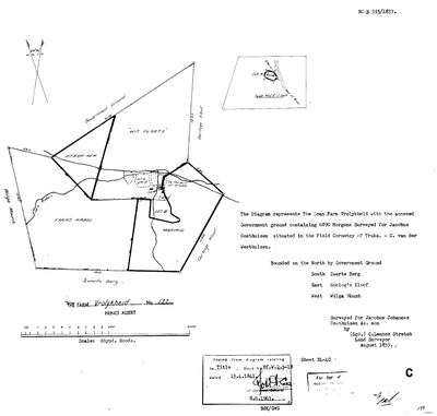 Landmeter-generaal-kaart, B355/1833, Augustus 1833
SCAN484.TIF
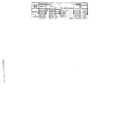 Kaart se keersy, B355/1833 (verso), Augustus 1833
SCAN485.TIF
death-notice-8586-1846-charles-frederik-hitge.jpg
Kadaster
Die Landmeter-generaal se kaartindeks vir hierdie perseel
Navorsingsnotas
original Marincowitz farm; Ger(H)olm d.1890 [29 Jul 2026] A third portion (Faans Kraal, PAR-000034) also cites the 1841 N. HitgeM title rather than this farm's own 1841 Oosthuisen grant as its antecedent - see DOC-0068/DOC-0069/DOC-0072. Neighbour Oorlogs Kloof (farm No.172, east boundary) confirmed via its own 1833 diagram, DOC-0073 - now tracked as PAR-000066 (29 Jul 2026). [29 Jul 2026] A different, unrelated farm also called Vrolykheid (No. 61, Tulbagh, DOC-0074) surfaced in the inbox - the Oosthuizen family is independently documented living at Tulbagh for two generations before the Koup (PER-000230, PER-000118). See LEAD-0010: whether this farm was named for that one, by memory rather than any land connection - not asserted, not settled.
[1 Aug 2026, re-read of DOC-0068 and DOC-0072] FIELD CORNETCY = KREDOUW. On BOTH 1934 Melville diagrams the printed line reads 'situate in the Field Cornetcy of' with TRAKA STRUCK OUT AND KREDOUW WRITTEN IN, in the surveyor's hand. Two independent sheets, the same deliberate correction. So this ground sat in the KREDOUW ward of the Prince Albert division, not the Traka ward - and that is the answer to where 'aan Kriedouw' in the 1821 Beaufort West baptisms points. See LEAD-0052.
[6 Aug 2026, SRC-294] [FAMILY] A HOUSEHOLD ON THIS GROUND IN 1809, twenty-four years before Stretch measured it. Fred van Zyl states that Ockert Jacobus OosthuizenL (PER-000211) was born on Vrolikheid in 1809, which places his father Jacobus Johannes - the man the 1833 diagram was surveyed for - here a full generation earlier. This project's documented occupation of the farm starts with that survey; if the 1809 birth holds, the occupation starts with a loan-farm household nobody has yet found a paper for. It is testimony, not a document, and the 1809 baptism entry would name the farm and settle it. [TO VERIFY] LEAD-0110.
Werknotas, hier gewys omdat dit 'n private navorsingsbou is.
Die werksnotas op hierdie werf word in Engels gehou en word nie vertaal nie. Hulle verander met elke navorsingsessie, en 'n vertaling sou uit pas raak met die oorspronklike. Alles anders — die stories, die getranskribeerde dokumente en die koppelvlak — is in Afrikaans.
Oop vrae
-
Who was Petrus Oosthuizen of Klaarstroom, and how is he related?
prioriteit 1 · LEAD-0029
The village at the centre of this project's anchor was laid out on his land in 1858-60 and originally named Petersburg for him. He is not in the model's family. Where does he sit, and is he a descendant of the root couple?
Wat dit sou uitmaak The death notice - it names parents, spouses and surviving children.
-
Which congregation baptised Jan de Bruijn in 1769?
prioriteit 1 · LEAD-0030
The register page (SRC-168) gives the entry in full but not the church. If it is Roodezand/Tulbagh, the de Bruin family is a Tulbagh family and the Vrolykheid name-transfer of LEAD-0010 has a documented carrier. If it is Drakenstein or Swellendam, it does not.
Wat dit sou uitmaak The waypoint. This is a thirty-second lookup, not a research task.
-
Nicolaus Hitge's will and estate account, 1848 - does it hold Wit Plaats?
prioriteit 1 · LEAD-0097
Is the 'N. HitgeM' granted Wit Plaats on 15 April 1841 the Uitenhage shopkeeper Nicolaus HitgeM (1785-1848)?
Wat dit sou uitmaak The estate account lists the immoveable property. If Wit Plaats or Vrolykheid appears in it, PER-000044 is PER-000328 and the row can be merged. If the estate holds only Uitenhage property, the 1841 grantee is a different Hitge and the search moves to the 1841 deed itself. Now with a specific thing to look for: DOES THE ESTATE LIST SANDFONTEIN, WIT PLAATS, OR BOTH? If Sandfontein only, close this lead in the negative and the search moves to the 1841 deed and to the OTHER Hitge men - his sons Conrad Anthony and George Joseph Roy were adults by then.
-
Was a van Zyl household living on Middelwater in 1839, and was Jacobus Johannes on Vrolikheid in 1809?
prioriteit 1 · LEAD-0110
Fred van Zyl states that his great-grandfather Jan Adriaan van Zyl was born on Middelwater on 9 November 1839, and that Ockert Jacobus OosthuizenL was born on Vrolikheid in 1809. Both would put named households on this project's core ground a generation earlier than its documents do.
Wat dit sou uitmaak The two baptism entries. Each names the farm and the parents in the same line.
-
N. Hitge's true footprint on Vrolykheid - and his relationship to Frans's own Hitge ancestors
prioriteit 2 · LEAD-0009
Did N. HitgeM's 1841 title (B.W.Q.5.18) actually cover more of Vrolykheid than the ~2,177-morgen Wit Plaats portion recorded for him - and how is N. HitgeM (PER-000044) related to Aletta Catharina Maria Helena HitgeM (PER-000139, Frans's own direct 2x-great-grandmother) and to Hester Carolina Adriana HitgeM (PER-000178, who married into the Marincowitz line)?
Wat dit sou uitmaak A record giving N. HitgeM's full given name and naming his children, matched against Aletta Catharina Maria Helena HitgeM (b.1846) and Hester Carolina Adriana HitgeM (b.1826) - if both are his daughters, or one his daughter and the other a niece or cousin, that settles the family relationship and gives a documented reason one 1841 title could legitimately be cited across multiple later Vrolykheid portions, subdivided within the Hitge family before ever reaching Marincowitz hands
-
Is the Koup's Vrolykheid named for the Tulbagh farm of the same name?
prioriteit 2 · LEAD-0010
Jacobus OosthuizenL (PER-000230) and Dina Carolina BritzM raised their family at Tulbagh from 1749 into the 1770s-80s, including Ockert (PER-000118, b.1755), the root ancestor's own father. A different, independently surveyed farm called Vrolykheid (No. 61, in the Kom van Tulbagh, erfpacht loan-place of T.G. HugoM, surveyed 1816) sits in exactly that district. Is the Koup's Vrolykheid (PAR-000014, granted 1841 to an unidentified Jacobus Johannes OosthuisenH, 'Andries son') named after this Tulbagh farm, carried as a remembered place-name rather than any documented land connection?
Wat dit sou uitmaak A document placing the Oosthuizen family (or specifically PER-000043's own branch) at or near the Tulbagh Vrolykheid, or naming the Koup farm's origin explicitly; short of that this stays a plausible but unproven toponymic-transfer hypothesis, the same kind this project has already tested once for the surname Oosthuizen itself (SRC-103)
-
Where exactly is Vischat / 'fisgat', and what is its real name?
prioriteit 2 · LEAD-0018
Vischat is where Frans's grandfather Hendrik Lodewyk Malherbe OosthuizenM farmed until 1979 and where his father CJJ grew up, yet the model has no ground for it: no extent, no geometry, no ownership row, no document. Which parcel does it actually sit on, and is the name Vischgat/Visgat?
Wat dit sou uitmaak The purchase deed - it will name the parcel Vischat forms part of. Failing that, a topo sheet showing the werf, or CJJ simply saying which farm it was on.
-
Two households widowed 24 hours apart, July 1846 - one event or two?
prioriteit 2 · LEAD-0102
Charles Frederick HitgeL died 29 July 1846 and Anna Magdalena StrijdomM died the very next day. Both survivors remarried within the year, a married couple also died that year, and 1846 ties as the heaviest pre-1890 death year in this record. Was there a mortality event in the district that July?
Wat dit sou uitmaak A cause of death on either notice, or a visible excess of burials in the register for those months.
-
Fourteen children of Ockert Jacobus Oosthuizen (b.1809) are missing from this model
prioriteit 2 · LEAD-0109
Fred van Zyl states that PER-000211, born on Vrolikheid in 1809 and the man who named the Marico Klaarstroom, had fourteen children - one of them Susara Cornelia Oosthuizen, who married Fred's great-grandfather Jan Adriaan van Zyl. This model records none of them. Who were they?
Wat dit sou uitmaak A register or the descendant compilation Fred already holds. Susara Cornelia is the one to start with, because her marriage to Jan Adriaan van Zyl dates and places the family.
-
A 1907 petition names James Caithness Marincowitz of Vrolykheid, suing his wife for restitution of conjugal rights
prioriteit 2 · LEAD-0185
NAAIRS (supplied by Frans in chat indexes a Cape Supreme Court motion: PETITION OF JAMES CAITHNESS MARINCOWITZ OF VROLYKHEID, DIVISION OF PRINCE ALBERT, FOR LEAVE TO SUE HIS WIFE JOHANNA DOROTHEA CORNELIA ELIZABETH COETZEE BY EDICTAL CITATION FOR RESTITUTION OF CONJUGAL RIGHTS. Is the petitioner PER-000195 (b. 18 Jun 1866, d. 1934), and what does the file say about the household on Vrolikheid in 1907?
Wat dit sou uitmaak The CSC file itself. It will name the marriage date and place, the desertion account, and where she was thought to be - household detail for Vrolikheid in 1907 that no farm paper carries.
-
De Claar Stroom: one parcel or two?
prioriteit 3 · LEAD-0039
PAR-000004 is the 1777 loan farm De Claar Stroom and PAR-000097 is cadastral farm 178, the ground Klaarstroom village stands on. Should they be one parcel row or two?
Wat dit sou uitmaak The extent on the 178 title, compared with the loan farm's described run. If they are the same ground, one row; if 178 is a part, two.
Wat die rekord kortkom
-
The record stops in 1890 and never resumes
second order · B2 trail-ends
Vrolikheid was worked as far as 1890-05-13, with Ger(H)olm Marincowitz the last owner on record. 136 years follow with nothing. Who held it after that, and is it still one farm?
What would settle it The current title deed traced backwards, each transfer names the one before it, or the Surveyor-General's subdivision diagrams, which are what usually explain a farm going quiet.
Found by breaks.py reading the model against itself, not written by hand,
each one is a shape of missing record, not a fault in the data.
The whole set is on the
questions page.