Landmeter-generaal-kaart, 4933/1934, Julie 1934
Landmeter-generaal-kaart, Julie 1934
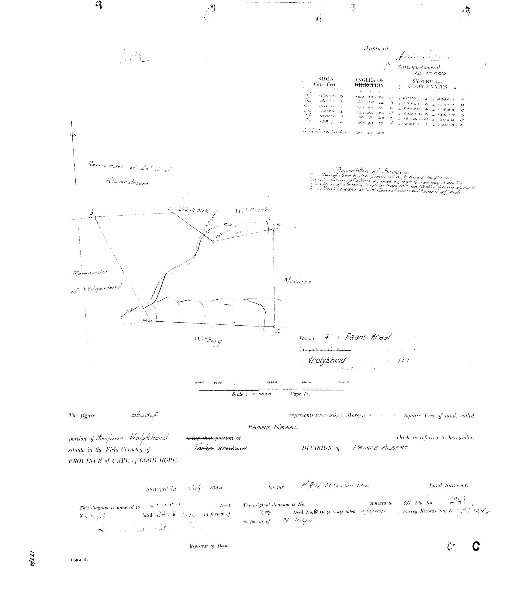
10X2V901.TIF.Die rekord
- Soort
- Landmeter-generaal-kaart
- Kaartnommer
- 4933/1934
- Opgemeet
- Julie 1934
- Getitel
- 24 Augustus 1936
- Akte
- 8110
- Landmeter
- P.A.H. Melville (signature, reading uncertain)
- Argieflêernaam
- 10X2V901.TIF
Sitasie
- Title
- Vrolykheid Portion 4 "Faans Kraal" diagram
- Repository
- Surveyor-General
- Reference
- SG Dgm 4933/1934
- Type
- SG diagram
Die grond waaroor dit gaan
Faans Kraal (Vrolikheid Nr. 177 Gdlt 4) 4/177
Navorsingsnotas
"Portion 4 (Faans Kraal), a portion of Vrolykheid No.177, Prince Albert." Field Cornetcy given as Traka, struck through and corrected in hand to Kredouw - same correction as DOC-0068/DOC-0069. Surveyed July 1934, approved by the Surveyor-General 12-1-1935. Extent 213.5677 morgen [CONFIRMED 29 Jul 2026: DOC-0028's verso, re-read, gives Faans Kraal 177/4 exactly 213.5677mg - the model's earlier 213.9677 was the verso misread, now corrected in parcels.csv]. "This diagram is annexed to Transfer Deed No. 8110 dated 24.8.1936" - matches parcels.csv's own pre-existing note (SG Dgm 4933/1934; deed 24.8.1936-8110) and DOC-0028's verso deductions summary for Marinco/Faans Kraal/Lot A exactly, unlike the Marinco/DOC-0068 conflict. The grantee's name on this diagram's own transfer line is illegible on the scan; attributed to V.C. Marincowitz (PER-000045) on the strength of the deed/date match with DOC-0028 and the family pattern (same buyer as Uitkyk Nek and Marinco) - confidence held at high since no conflicting reading exists, but the name itself was not read directly off this scan. "The original diagram is No. [blank] annexed to Title Deed No. (B.W.Q.5.18) dated 15/4/1841 in favour of N. HitgeM" - a THIRD Vrolykheid portion citing the Hitge title rather than the Oosthuisen grant; see DOC-0068/DOC-0069/PAR-000014 notes for the open question this raises. Surveyor signature reads approximately "P.A.H. Melville" - possibly the same hand as DOC-0068/DOC-0069's "J.A.H. Melville", reading uncertain both times, not asserted as the same or a different person. Neighbours shown on this diagram: Uitkyk Nek (PAR-000032), Wit Plaats (PAR-000031), Marinco (PAR-000035), Remainder of Wilgemond, Remainder of Lot C of Klaarstroom, Witberg.
[3 Aug 2026] publish_ok=yes. This is an OLD FARM DIAGRAM held back only because a TRANSFER ENDORSEMENT on its face crosses the 1936 scan cut-off - the survey itself is from the 1920s or 1930s. The names on it are the surveyor, the neighbouring farms and a transferee of the 1930s or 1940, all long dead and most of them already published as person records here. Reviewed individually, not opened as a category.
Die navorsing agter hierdie bladsy, apart gehou daarvan: gedateerde werksnotas, oop vrae, en wat nog nie uitgemaak is nie.
Die werksnotas op hierdie werf word in Engels gehou en word nie vertaal nie. Hulle verander met elke navorsingsessie, en 'n vertaling sou uit pas raak met die oorspronklike. Alles anders — die stories, die getranskribeerde dokumente en die koppelvlak — is in Afrikaans.