Brasse Fontein No. 371
· on record 1895–1914 · show on the map
- Farm number
- No. 371
This parcel has no matched survey polygon, so it cannot be drawn on the map. That is a gap in the cadastre match, not an absence from the record.
Why this farm is here
Christina Elisabeth Nel lived on this ground, a blood relative of the Oosthuizen, Marincowitz or Van der Merwe lines, 1 step away. Not yet placed on the map.
Each step is a recorded parentage or marriage in this model, and the shortest one the record supports, follow the names to check it.
- document A document in the collection describes this ground DOC-0289
- document A document in the collection describes this ground DOC-0290
What the record holds, in order
-
28 February 1895
lived here
Christina Elisabeth Nel (22 August 1867–28 February 1895)
died there · to 1895-02-28
-
August 1912
document
SG diagram 1567/1912
Transfer 9858 (26 Nov 1912)
-
January 1914
document
SG diagram 949/1914
Transfer 8683 (30 Dec 1915)
Bordered by, as the diagram names them
- N Brasse Fontein Remainder
- E Glen Searle (Brasse Fontein Portion 1)
- S Riet Kolk or Oudemuur
- NW Piet Louws Valley
- NE Bras zyn Plaats (Calvinia farm No. 301)
- SE Brasse Fontein Remainder
Documents
 Surveyor-General diagram, 1567/1912, August 1912
10051901 371 1.jpg
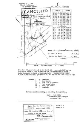 Surveyor-General diagram, 949/1914, January 1914
10051902 371 2.jpg
Research notes
[11 Aug 2026, SRC-400, SRC-412] WHERE CHRISTINA ELIZABETH NEL DIED, aged 27, on 28 February 1895, leaving five children all under age. Her death notice writes it BRASFONTEIN, CALVINIA; the cadastre calls the farm BRASSE FONTEIN and numbers it 371. Frans identified the number and the grant. IT WAS GRANTED TO A VAN WYK, AND HER MOTHER WAS A VAN WYK. Anna Jacoba van WykM 1842-1925 is her mother, so she died on her mother's family's ground. That is the second time in three generations this family is living on land that came in through a woman: her husband's grandfather died on LOKENBURG in 1866, which had come in through HIS wife, the Lokenburg widow's daughter. AND IT SITS WHERE THE FAMILY WAS. 371 is at -31.0232, 20.3272 - about 55 km south of Brandvlei, where she married in 1885 and where her husband died in 1956, and a long way east of the Oude Muur and Tygerhoek country the van der Merwes held. NO DOCUMENT HELD HERE YET PUTS EITHER FAMILY ON THE TITLE. The grant to a van Wyk is Frans's, and the diagrams for this farm are in the inbox unread as this row is written. LEAD-0172.
[11 Aug 2026, SRC-414] THIS PIN IS NOW IN DOUBT AND SHOULD NOT BE RELIED ON. The 1878 diagram for Brasse Fontein 371 puts it in the FIELD-CORNETCY OF ACHTER HANTAM and gives its southern boundary as "Riet Kolk of Oude Muur". The polygon this row carries, from the Calvinia cadastre's PARCEL_NO 371, sits at -31.0232, 20.3272 - about 110 km east of Oude Muur 619 and well out of the Hantam. A farm does not bound a farm 110 km away. Either the boundary names a second Oude Muur or this polygon is not the Brasse Fontein of the diagram. LEAD-0173.
[11 Aug 2026] TESTED AND THE PIN STANDS. The diagram names five neighbours and the Calvinia cadastre puts every one of them around this polygon: BRAS ZYN PLAATS no.301 at 5.1 km, RIET KOLK no.385 at 5.1 km, WIT KLIP no.372 at 6.5 km, PIET LOUWS VLEY no.302 at 9.0 km and WITFONTEIN no.299 at 13.7 km. All five are 97 to 118 km from Oude Muur 619. Five neighbours cannot be wrong together. SO "RIET KOLK OF OUDE MUUR" ON THE DIAGRAM IS RIET KOLK No. 385, A SECOND FARM CALLED OUDE MUUR, five kilometres south of this one and 104 km from the family's Oude Muur. THAT IS THE FINDING, and it is a warning this project needs: the name Oude Muur is on at least three pieces of ground now - farm 619 in the Hantam where PER-001629 was born and died, the Prince Albert Marincowitz farm PAR-000029, and Riet Kolk 385 in the eastern Calvinia division. Anyone reading "Oude Muur" in a document from now on has to say WHICH.
The research behind this page, kept separate from it: dated working notes, open questions, and what is not yet settled.
Open questions
-
Brasse Fontein 371 is pinned 110 km from a farm its own diagram says it adjoins
priority 1 · LEAD-0173
The 1878 diagram gives Brasse Fontein 371's southern boundary as "Riet Kolk of Oude Muur" and places it in the field-cornetcy of Achter Hantam. The Calvinia cadastre's parcel 371 sits 110 km east of Oude Muur 619. Which is wrong: the pin, or the assumption that the boundary means the family's Oude Muur?
What would settle it Any one of the five named neighbours located in the cadastre.
-
Read the diagrams for Brasse Fontein 371 and Welbedagt 555
priority 2 · LEAD-0172
Five SG diagrams are in the inbox unread: 10051901 and 10051902 for farm 371 in two parts, 10052409 for 371, and 10053943 and 10053944 for Welbedagt 555. Do any of them name a van Wyk, a Nel or a van der Merwe on the title or a boundary?
What would settle it A van Wyk on the title of 371, or a van der Merwe on 555.
-
Who is the Jacobus A. van der Merwe who took Brassefontein West in 1915?
priority 2 · LEAD-0176
Is the Jacobus A. van der Merwe of transfer 8683, 30 December 1915, a member of this family?
What would settle it Full given names or a birth date on the deed. Initials alone will not do it.
What the record is missing
-
“Brasse Fontein Remainder” is named as a neighbour 2 times and we hold no parcel for it
third order · B3 unheld-farm
2 separate surveys in this model put Brasse Fontein Remainder on the boundary of ground we do hold (PAR-000200). It has no parcel of its own here, so nothing is known about who held it or when, while it borders farms at the centre of the project.
What would settle it The Surveyor-General's farm index for the registration division will give it a farm number and a diagram; the cadastre pull in `data/fetch_cadastre.py` then places it on the map.
-
Nobody is on record as ever having held this
third order · B8 never-held
Brasse Fontein No. 371 is in the model, and carries no ownership record of any kind, not a grant, not a transfer, not an occupation.
What would settle it The Surveyor-General's diagram for the farm number names the grantee and the date; the deed reference on it opens the transfer chain.
Found by breaks.py reading the model against itself, not written by hand,
each one is a shape of missing record, not a fault in the data.
The whole set is on the
questions page.