Surveyor-General diagram, 922/1872, 6 June 1872
Surveyor-General diagram, 6 June 1872
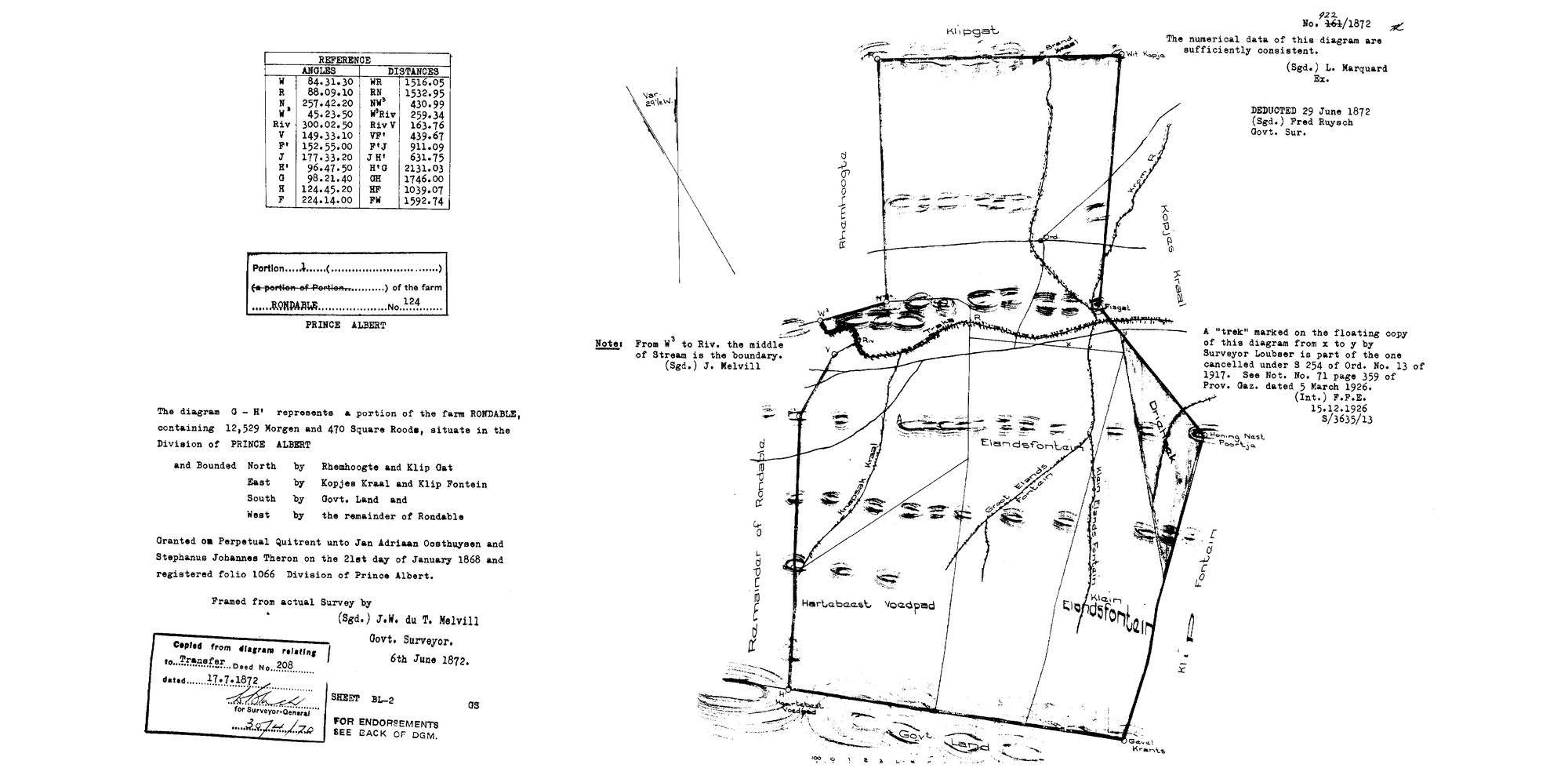
10JDF101 124 1.jpg.The record
- Type
- Surveyor-General diagram
- Diagram number
- 922/1872
- Surveyed
- 6 June 1872
- Titled
- 21 January 1868
- Deed
- Transfer 208 of 17.7.1872; P.A.Q. 1-21, folio 1066
- Surveyor
- J.W. du T. Melvill
- Examiner
- L. Marquard
- Archive filename
- 10JDF101 124 1.jpg
Citation
- Title
- SG Dgm 922/1872 - Portion 1 of the farm Rondable No. 124, Prince Albert
- Repository
- Landmeter-Generaal, Kaapstad
- Reference
- No. 922/1872 (written over a struck 161/1872); framed from actual survey 6 June 1872 by J.W. du T. Melvill, Govt. Surveyor; examiner L. Marquard; deducted 29 June 1872, Fred Ruysch, Govt. Sur.; copied from the diagram relating to Transfer Deed No. 208 dated 17.7.1872; Sheet BL-2
- Type
- SG diagram
- Retrieved
- 2026-08-03
The ground it is about
Rondawel (Rondabel No. 124 Ptn 1) 1/124
Research notes
The diagram for the 1868 perpetual-quitrent grant of Rondabel to Jan Adriaan OosthuysenM and Stephanus Johannes TheronL. Melvill also surveyed Modderdrift in 1874 (DOC-0154).
[5 Aug 2026] This row used to list 2 filenames under one id, which made every sheet after the first unreachable - see 8. The others (10JDF501 124 1.jpg) were re-pulled and now have their own rows: DOC-0241. LEAD-0095 closed.
[5 Aug 2026] MERGED DOC-0026 INTO THIS ROW - one sheet, two rows. One archive image, 10JDF101, filed twice. Both scans were read side by side on 5 Aug 2026 and are the same sheet: diagram 922/1872 with 161/1872 struck through, Portion 1 of RONDABLE No. 124, 12,529 morgen 470 square roods, granted to Jan Adriaan OosthuysenM and Stephanus Johannes TheronL 21 January 1868, folio 1066, framed from actual survey by J.W. du T. MelvillM, 6th June 1872, copied from the diagram relating to Transfer 208 of 17.7.1872. DOC-0026 is retired rather than kept because every field it disagreed on was the wrong one: survey 1870-06-06 for a sheet dated 6 June 1872, surveyor J.A. de T. Melvill for J.W. du T. MelvillM, no diagram number at all, the parent farm instead of Portion 1, and 11,559 morgen for 12,529. DOC-0026 is retired and its id will never be reused. DISAGREEMENTS between the two rows, recorded rather than resolved: par_id: kept 'PAR-000115', DOC-0026 said 'PAR-000009'; original_filename: kept '10JDF101 124 1.jpg', DOC-0026 said '10JDF101.TIF'; source_file: kept 'sources/diagrams/DOC-0186-rondabel-124-ptn1-1872.jpg', DOC-0026 said 'sources/diagrams/DOC-0026-rondabel-portion-1870.tif'; survey_edtf: kept '1872-06-06', DOC-0026 said '1870-06-06'; deed_ref: kept 'Transfer 208 of 17.7.1872; P.A.Q. 1-21, folio 1066', DOC-0026 said 'P.A.Q.1-21'; surveyor: kept 'J.W. du T. MelvillM', DOC-0026 said 'J.A. de T. Melvill; resurvey 1872'; source_id: kept 'SRC-220', DOC-0026 said 'SRC-039'; image_edtf: kept '1872', DOC-0026 said '1870'. DOC-0026's own note read: 11559 morgen 470 sq roods, a portion of Rondable. "Granted on Perpetual Quitrent unto Jan Adriaan OosthuizenL and Stephanus Johannes TheronL on the 21st day of January 1868." Carries the same 1926 trek cancellation note (Loubser; Ord. 13 of 1917; Prov. Gaz. 5.3.1926) as Kopjes Kraal.
[1 Aug 2026, date audit] CHECKED, NOT AN ERROR: this row is titled 21 Jan 1868 and surveyed 6 Jun 1870, which reads backwards. It is the ordinary shape of a RESURVEY - the title date belongs to the 1868 grant and the diagram to the survey made two years afterwards. Left as it stands, noted so the next audit does not re-raise it.
The research behind this page, kept separate from it: dated working notes, open questions, and what is not yet settled.