Surveyor-General diagram, 1978/1875 (877/1875 struck), July 1874
Surveyor-General diagram, July 1874
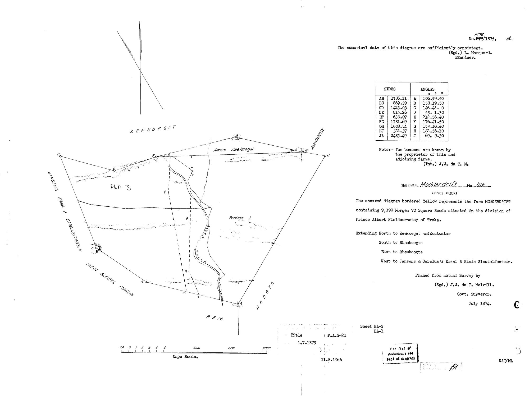
10J85S01 modderdrift 2.jpg.The record
- Type
- Surveyor-General diagram
- Diagram number
- 1978/1875 (877/1875 struck)
- Surveyed
- July 1874
- Titled
- 1 July 1879
- Deed
- P.A.2-21
- Surveyor
- J.W. du T. Melvill
- Examiner
- L. Marquard
- Archive filename
- 10J85S01 modderdrift 2.jpg
Citation
- Title
- Modderdrift No. 106 diagram, 1874 resurvey
- Repository
- Surveyor-General
- Reference
- SG Dgm 877/1875
- Type
- SG diagram
- Retrieved
- 2026-08-01
The ground it is about
Research notes
"The annexed diagram bordered Yellow represents the farm MODDERDRIFT containing 9,399 Morgen 70 Square Roods situated in the division of Prince Albert Fieldcornetcy of Traka. Extending North to Zeekoegat and Zoutwater, South to Rhemhoogte, East to Rhemhoogte, West to Jansens & Carolus's Kraal & Klein Sleutelfontein. Framed from actual Survey by (Sgd.) J.W. du T. MelvillM. Govt. Surveyor. July 1874." Examiner's note: "The numerical data of this diagram are sufficiently consistent. (Sgd.) L. MarquardM." Beacon note: "The beacons are known by the proprietor of this and adjoining farms. (Int.) J.W. du T. M." Title P.A.2-21, 1.7.1879; stamped 11.8.1966. The diagram number is amended in manuscript from 877/1875 to 1978. Sides AB 1386.11 to JA 2483.49 Cape Roods with angles, ten beacons A to J. Drawn on it: Annex Zeekoegat, the Traka river, a House, Portion 2, and a pencilled "PLN 3". This diagram supersedes DOC-0153. [2 Aug 2026, read from the sheet itself] THE DIAGRAM NUMBER WAS RENUMBERED: '877/1875' is STRUCK THROUGH on the sheet and '1978' written above it in manuscript, so this is 1978/1875. Both are kept - the struck number is what earlier references will cite. Re-stamped 11.8.1966. Sheet BL-2 / BL-1. Examiner's note: 'The numerical data of this diagram are sufficiently consistent. (Sgd.) L. MarquardM.' Surveyor's note: 'The beacons are known by the proprietor of this and adjoining farms. (Int.) J.W. du T. M.' A FULL CLOSED TRAVERSE is tabulated, beacons A-J, sides in Cape roods and angles to the second: AB 1386.11, BC 869.39, CD 1423.03, DE 815.26, EF 638.07, FG 1181.69, GH 1008.54, HJ 322.37, JA 2483.49. That is enough to re-plot the 1874 farm independently of the cadastre if it is ever wanted. The plan face names ANNEX ZEEKOEGAT, PORTION 2, a handwritten PTN 3, REM, a House, and the Traka running through it. *** 'For list of deductions see back of diagram' - THE VERSO IS THE SHEET THAT ANSWERS LEAD-0063, and it is not held. *** AND A FINDING BEYOND THIS FARM: this title is P.A.2-21 of 1 JULY 1879. Annex Modderdrift (PAR-000069, Rhemhoogte Ptn 3) cites Deed of Grant P.A.Q.2-20 of THE SAME DAY, off a survey of the same year (dgm 1149/1874). Consecutive folios, one date, both out of 1874 surveys - the same batch-grant fingerprint as 15 April 1841, thirty-eight years later. See STO-0007. [TO VERIFY] how many more farms were titled on 1 July 1879.
The research behind this page, kept separate from it: dated working notes, open questions, and what is not yet settled.