Annex Wilgeboom No. 891
· on record 1909 · show on the map
- Farm number
- No. 891
- District
- Calvinia (division)
- Extent, as the diagram states it
- 399 morgen 407 sq roods
- Modern surveyed area
- 337.6 ha
The historic extent and the modern surveyed area are two separate measurements and are not presented here as confirming each other. The first is what a surveyor wrote on a diagram, usually in morgen. The second is what the modern cadastre draws.
Why this farm is here
Described by a document in this collection. 278 km from Klaarstroom.
- document A document in the collection describes this ground DOC-0287
What the record holds, in order
- February 1909 document SG diagram 73/1909
Also bordered by, as the modern cadastre draws it
Ground that touches this farm on the Surveyor-General's current polygons and that none of the diagrams held here names. Derived from the geometry, not read off a document.
Documents
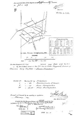 Surveyor-General diagram, 73/1909, February 1909
10055398 891.jpg
Research notes
[10 Aug 2026, SRC-372/DOC-0287] Surveyed February 1909 by FRED MULLER, the surveyor who laid out Alewyns Berg No. 694 five years later. 399 morgen 407 roods in the F.C. of NORTH ONDER ROGGEVELD. Bounded NW by Wilgeboom, E by Boschluiskrantz Extension, S by Annex Kleinefontein, SW by Annex Brakkefontein. D/G Clv. Q. 29-10. TITLE IN FAVOUR OF J. W. A. STEENKAMP AND THE ESTATE OF THE LATE J. W. C. STEENKAMP, certified 4 May 1910. With No. 892 that puts the Wilgeboom farms in Steenkamp hands across seventy-six years, 1834 to 1910. No van der Merwe connection is established. [TO VERIFY]
The research behind this page, kept separate from it: dated working notes, open questions, and what is not yet settled.
What the record is missing
-
Nobody is on record as ever having held this
third order · B8 never-held
Annex Wilgeboom No. 891 is in the model and drawn on the map, and carries no ownership record of any kind, not a grant, not a transfer, not an occupation.
What would settle it The Surveyor-General's diagram for the farm number names the grantee and the date; the deed reference on it opens the transfer chain.
Found by breaks.py reading the model against itself, not written by hand,
each one is a shape of missing record, not a fault in the data.
The whole set is on the
questions page.