Oude Muur Extension No. 610
· on record 1874 · show on the map
- Farm number
- No. 610
- District
- Calvinia (division)
- Extent, as the diagram states it
- 445 morgen 99 sq roods (1874, before deduction)
- Modern surveyed area
- 187.1 ha
The historic extent and the modern surveyed area are two separate measurements and are not presented here as confirming each other. The first is what a surveyor wrote on a diagram, usually in morgen. The second is what the modern cadastre draws.
Why this farm is here
Ground a written history is set on. 375 km from Klaarstroom.
- story A written history names this ground The van der Merwes of the Hantam
- document A document in the collection describes this ground DOC-0279
- document A document in the collection describes this ground DOC-0280
Stories
- mentions this farm
The van der Merwes of the Hantam
The maternal line, from Paarl in 1735 to Vredendal in about 1950, with every kinship spelled out. The crossing from the Piketberg district into the Hantam is dated to a fourteen-year window by two death notices; three farms were surveyed for the Commissie van Inspectie by one man in 1820 and 1823; a man called Kwaai Koos is named after his farm; and twice in three generations the family is standing on ground that came in through a woman.
What the record holds, in order
- 1874 document SG diagram 320/1874
- 1874 document SG diagram 320/1874 (deduction table)
Also bordered by, as the modern cadastre draws it
Ground that touches this farm on the Surveyor-General's current polygons and that none of the diagrams held here names. Derived from the geometry, not read off a document.
Documents
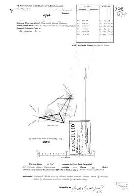 Surveyor-General diagram, 320/1874, 1874
10054451 610 0.jpg
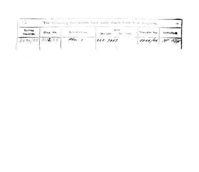 Surveyor-General diagram, 320/1874 (deduction table), 1874
10054452 610 0.jpg
Research notes
[10 Aug 2026, SRC-367/DOC-0279] 'Lot A Oude Muur Extension', a CROWN LAND farm surveyed 1874 by Wm. de Smidt Junr., Field-cornetcy of North Onder Bokkeveld, 445 morgen 99 roods, 942.21 acres. IT GIVES THE SEAT A SECOND NAME. The boundary reads 'West and North West by SLAAI ACKER OR OUDE MUUR' - so Oude Muur No. 619, where Schalk Willem Burger van der MerweM was born and died, is also known as SLAAI ACKER. Two names, one farm, both kept. Also bounded by Heitoes, East by Palmiet Fontein, South by Melkbos Rug. The face names Zari Laagte, Brak Laagte and a general path. Beacons pointed out to Field Cornet J.A. Nieuwoudt, S.V. van Breda and J. Poole - the same three men as both Alewyns Berg sheets, so these surveys are one season's work. THE SHEET IS STAMPED CANCELLED, and the deduction table says why: Portion 1 of 222.7957 morgen was cut off on diagram 3032/55, transfer 5064/66. 445 morgen less 222.8 leaves about 190 ha, and the modern polygon is 187.1 ha. The arithmetic closes, which is what identifies the parcel.
The research behind this page, kept separate from it: dated working notes, open questions, and what is not yet settled.
What the record is missing
-
Nobody is on record as ever having held this
third order · B8 never-held
Oude Muur Extension No. 610 is in the model and drawn on the map, and carries no ownership record of any kind, not a grant, not a transfer, not an occupation.
What would settle it The Surveyor-General's diagram for the farm number names the grantee and the date; the deed reference on it opens the transfer chain.
Found by breaks.py reading the model against itself, not written by hand,
each one is a shape of missing record, not a fault in the data.
The whole set is on the
questions page.