Oude Muur No. 619
· on record 1820 · show on the map
- Farm number
- No. 619
- District
- Calvinia (division)
- Modern surveyed area
- 1595.1 ha
Why this farm is here
Ground a written history is set on. 378 km from Klaarstroom.
- story A written history is set on this ground The van der Merwes of the Hantam
- story A written history names this ground Four grandparents, four countries
- document A document in the collection describes this ground DOC-0271
Stories
- set here
The van der Merwes of the Hantam
The maternal line, from Paarl in 1735 to Vredendal in about 1950, with every kinship spelled out. The crossing from the Piketberg district into the Hantam is dated to a fourteen-year window by two death notices; three farms were surveyed for the Commissie van Inspectie by one man in 1820 and 1823; a man called Kwaai Koos is named after his farm; and twice in three generations the family is standing on ground that came in through a woman.
- mentions this farm
Four grandparents, four countries
How four grandparents out of four lines met: three weddings in four years at Bellville and Williston, and a fourth marriage that tied two of them back together after both were widowed. Each line has its own page; this one is the join. Of the four countries the title promises, this record can point at one on a map.
What the record holds, in order
-
31 January 1820
document
SG diagram 328/1820
Title Wor. Q. 5-52 dated 20.2.1832
Buried on this ground
- Nieuwoudville Oudemuur 619 (Calvinia district) 0 graves recorded
The burials also appear on this farm's timeline above, each at its own date.
Also bordered by, as the modern cadastre draws it
Ground that touches this farm on the Surveyor-General's current polygons and that none of the diagrams held here names. Derived from the geometry, not read off a document.
Documents
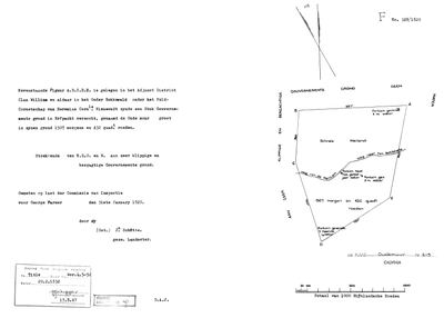 Surveyor-General diagram, 328/1820, 31 January 1820
10054360 619 0.jpg
Research notes
[10 Aug 2026] THE SEAT OF THIS LINE FOR AT LEAST SEVENTY-ONE YEARS. Schalk Willem Burger van der MerweM (PER-001629) was born here on 23 February 1833 and died here on 17 January 1904, and his son Frans Jacobus Wilhelmus (PER-000762) is recorded resident on 'Farm Oude Muur' in 1897 [SRC-348]. PLC-000053 is the place; this is its cadastral parcel, from the national CSG portal. OUDE MUUR EXTENSION No. 610 adjoins it, 187.1 ha, and has no row here. THREE FARMS CARRY THIS NAME AND ONLY THIS ONE IS THE VAN DER MERWES': Calvinia 619 here, PRINCE ALBERT 121 (PAR-000029, the Marincowitz farm) and SUTHERLAND 160.
The research behind this page, kept separate from it: dated working notes, open questions, and what is not yet settled.
Open questions
-
Brasse Fontein 371 is pinned 110 km from a farm its own diagram says it adjoins
priority 1 · LEAD-0173
The 1878 diagram gives Brasse Fontein 371's southern boundary as "Riet Kolk of Oude Muur" and places it in the field-cornetcy of Achter Hantam. The Calvinia cadastre's parcel 371 sits 110 km east of Oude Muur 619. Which is wrong: the pin, or the assumption that the boundary means the family's Oude Muur?
What would settle it Any one of the five named neighbours located in the cadastre.
-
The Hantam ground has no basemap under it
priority 3 · LEAD-0167
The Calvinia farms are on the map as polygons but sit over blank canvas, and the four Northern Cape cemeteries have no pins at all. What is missing, and is it worth fetching?
What would settle it A re-cut basemap covering the Hantam, and a sourced coordinate for each town cemetery.
What the record is missing
-
Nobody is on record as ever having held this
third order · B8 never-held
Oude Muur No. 619 is in the model and drawn on the map, and carries no ownership record of any kind, not a grant, not a transfer, not an occupation.
What would settle it The Surveyor-General's diagram for the farm number names the grantee and the date; the deed reference on it opens the transfer chain.
Found by breaks.py reading the model against itself, not written by hand,
each one is a shape of missing record, not a fault in the data.
The whole set is on the
questions page.