Lokenburg No. 815
· on record 1820–1823 · show on the map
- Farm number
- No. 815
- District
- Calvinia (division)
- Modern surveyed area
- 7037.0 ha
Why this farm is here
Maria Elisabeth Louw held it, and no kinship to the Oosthuizen, Marincowitz or Van der Merwe lines is recorded, this ground entered through the land, not the family. 365 km from Klaarstroom.
- story A written history is set on this ground The van der Merwes of the Hantam
- story A written history names this ground Four grandparents, four countries
- document A document in the collection describes this ground DOC-0275
- document A document in the collection describes this ground DOC-0276
- …and 2 more, listed in full further down this page.
Stories
- set here
The van der Merwes of the Hantam
The maternal line, from Paarl in 1735 to Vredendal in about 1950, with every kinship spelled out. The crossing from the Piketberg district into the Hantam is dated to a fourteen-year window by two death notices; three farms were surveyed for the Commissie van Inspectie by one man in 1820 and 1823; a man called Kwaai Koos is named after his farm; and twice in three generations the family is standing on ground that came in through a woman.
- mentions this farm
Four grandparents, four countries
How four grandparents out of four lines met: three weddings in four years at Bellville and Williston, and a fourth marriage that tied two of them back together after both were widowed. Each line has its own page; this one is the join. Of the four countries the title promises, this record can point at one on a map.
What the record holds, in order
-
17 February 1820
document
SG diagram 339/1820 (part 1)
Wor. Q. 5-66 dated 20.2.1832
-
17 February 1820
document
SG diagram 339/1820 (part 2)
Wor. Q. 5-66 dated 20.2.1832
-
17 February 1820
document
SG diagram 339/1820 (deduction table)
Wor. Q. 5-66 dated 20.2.1832
-
17 February 1820
document
SG diagram 339/1820 (manuscript original)
Wor. Q. 5-66 dated 20.2.1832
-
17 February 1820
ownership
Maria Elisabeth Louw (?–2 August 1823)
erfpacht · survey · confidence high
-
9 September 1823
estate
Maria Elisabeth Louw (?–2 August 1823)
MOOC8/75.66 · Lokenburg, Onder Bokkeveld, drostdy Clan William
Documents
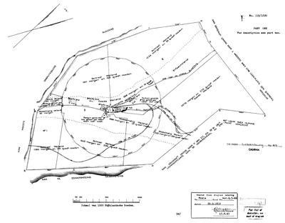 Surveyor-General diagram, 339/1820 (part 1), 17 February 1820
10021169 815 0.jpg
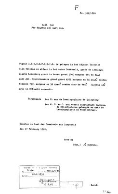 Surveyor-General diagram, 339/1820 (part 2), 17 February 1820
10021170 815 0 .jpg
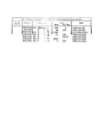 Surveyor-General diagram, 339/1820 (deduction table), 17 February 1820
10021171 815 0.jpg
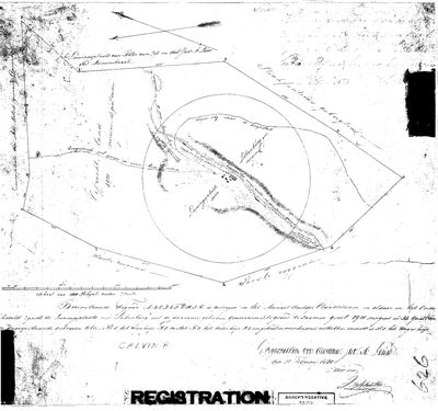 Surveyor-General diagram, 339/1820 (manuscript original), 17 February 1820
10205781 815 0.jpg
Research notes
[10 Aug 2026] WHERE SCHALK WILLEM VAN DER MERWE DIED, 29 May 1866, 'ter plaats Lokenburg' on his own death notice [SRC-346] - the notice that also named his parents and turned the 1833 marriage into a first-cousin marriage. He was born at Elsenbosch in the Piketberg district in 1794 and died here, which is the span of the family's move into the Hantam. PLC-000054 is the place. The largest of the three farms added today at 7,037 ha, and it sits about 27 km south-west of Tygerhoek.
The research behind this page, kept separate from it: dated working notes, open questions, and what is not yet settled.
Open questions
-
The Hantam ground has no basemap under it
priority 3 · LEAD-0167
The Calvinia farms are on the map as polygons but sit over blank canvas, and the four Northern Cape cemeteries have no pins at all. What is missing, and is it worth fetching?
What would settle it A re-cut basemap covering the Hantam, and a sourced coordinate for each town cemetery.
What the record is missing
-
The record stops in 1820 and never resumes
second order · B2 trail-ends
Lokenburg No. 815 was worked as far as 1820-02-17, with Maria Elisabeth LouwH the last owner on record. 206 years follow with nothing. Who held it after that, and is it still one farm?
What would settle it The current title deed traced backwards, each transfer names the one before it, or the Surveyor-General's subdivision diagrams, which are what usually explain a farm going quiet.
Found by breaks.py reading the model against itself, not written by hand,
each one is a shape of missing record, not a fault in the data.
The whole set is on the
questions page.