Tyger Hoek Extension No. 688
· on record 1879–1885 · show on the map
- Farm number
- No. 688
- District
- Calvinia (division)
- Extent, as the diagram states it
- 510 morgen 532 sq roods
- Modern surveyed area
- 430.9 ha
The historic extent and the modern surveyed area are two separate measurements and are not presented here as confirming each other. The first is what a surveyor wrote on a diagram, usually in morgen. The second is what the modern cadastre draws.
Why this farm is here
Francois Johannes van der Merwe held it. 343 km from Klaarstroom.
Francois Johannes van der Merwe is on record on this ground directly. No trace needed.
- story A written history names this ground The van der Merwes of the Hantam
- border Shares a boundary with Tygerhoek No. 689 Tygerhoek No. 689
- document A document in the collection describes this ground DOC-0270
Stories
- mentions this farm
The van der Merwes of the Hantam
The maternal line, from Paarl in 1735 to Vredendal in about 1950, with every kinship spelled out. The crossing from the Piketberg district into the Hantam is dated to a fourteen-year window by two death notices; three farms were surveyed for the Commissie van Inspectie by one man in 1820 and 1823; a man called Kwaai Koos is named after his farm; and twice in three generations the family is standing on ground that came in through a woman.
What the record holds, in order
- 1879 document SG diagram 165/1880
-
27 August 1885
ownership
Francois Johannes van der Merwe
quitrent · grant · confidence high
Bordered by, as the diagram names them
- NW Klipfontein
- NW Crown Land
- E Tyger Hoek
- W Vygge Vlakte
- S Klipfontein Extension
Also bordered by, as the modern cadastre draws it
Ground that touches this farm on the Surveyor-General's current polygons and that none of the diagrams held here names. Derived from the geometry, not read off a document.
Documents
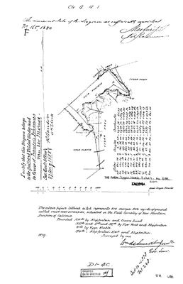 Surveyor-General diagram, 165/1880, 1879
10054524 688 0.jpg
Research notes
[10 Aug 2026, SRC-360/DOC-0270] Surveyed 1879 by Wm. de Smidt Junr. and granted on quitrent to FRANCOIS JOHANNES VAN DER MERWE, title issued 27 August 1885. The first documented landholding this project has for the van der Merwe line in any district. An extension to Tygerhoek No. 689, which it names as its own neighbour. NO POLYGON, as for its parent.
[10 Aug 2026] PINNED. The Calvinia division is not in the Western Cape warehouse, so it was pulled from the NATIONAL Chief Surveyor-General portal instead - fetch_cadastre.py --csg=CALVINIA. The cadastre names it exactly as the diagram does, and the extents agree: Tyger Hoek Extension is 430.9 ha against the 1879 survey's 510 morgen 532 roods, which is 437.6 ha, a difference of 1.5%. Tygerhoek is 4,033.2 ha against the 1823 figure of 4,446 morgen 399 roods, 3,808.7 ha, a difference of 5.9% across two centuries and a resurvey. The identification does not rest on the name.
The research behind this page, kept separate from it: dated working notes, open questions, and what is not yet settled.
Open questions
-
Who were the Tygerhoek van der Merwes, and how do Francois Johannes and the widow Burger connect to the line?
priority 1 · LEAD-0149
Carel Aaron van der MerweL's household was on Tygerhoek by 1808. The 1823 survey names the holder as the widow of William Petrus Burger, and the 1885 quitrent for the adjoining Tyger Hoek Extension goes to Francois Johannes van der MerweH. How do those two connect to the direct line?
What would settle it A marriage or baptism linking the widow Burger to the van der Merwes, and a parentage for Francois Johannes.
What the record is missing
-
The record stops in 1885 and never resumes
second order · B2 trail-ends
Tyger Hoek Extension No. 688 was worked as far as 1885-08-27, with Francois Johannes van der MerweH the last owner on record. 141 years follow with nothing. Who held it after that, and is it still one farm?
What would settle it The current title deed traced backwards, each transfer names the one before it, or the Surveyor-General's subdivision diagrams, which are what usually explain a farm going quiet.
Found by breaks.py reading the model against itself, not written by hand,
each one is a shape of missing record, not a fault in the data.
The whole set is on the
questions page.