Part of Klein Valie No. 182
Groote Leegte (Klein Valie No. 182 Ptn 5)
5/182 on the cadastre · on record 1912 · show on the map
The farm's own history, the grant, the original survey, sits on that page.
- Farm number
- No. 182
- Portion
- 5
- On the cadastre
- 5/182, portionregistered as KLEIN VALIE
- District
- Prince Albert
- Extent, as the diagram states it
- 345 morgen 476 square roods
- Modern surveyed area
- 296.2 ha
The historic extent and the modern surveyed area are two separate measurements and are not presented here as confirming each other. The first is what a surveyor wrote on a diagram, usually in morgen. The second is what the modern cadastre draws.
Why this farm is here
A piece of a farm already in this model. 7 km from Klaarstroom.
- parcel Cut out of Klein Valie No. 182
- document A document in the collection describes this ground DOC-0229
What the record holds, in order
- 1912 boundary change subdivision: from Klein Valie No. 182
- July 1912 document SG diagram 2118/1912
Also bordered by, as the modern cadastre draws it
Ground that touches this farm on the Surveyor-General's current polygons and that none of the diagrams held here names. Derived from the geometry, not read off a document.
- N Groenkraal (Klein Valie No. 182 Ptn 7)
- E Wilgemond No. 179
- SW Drie Punt No. 181
- W Grootleegte (Klein Valie No. 182 Ptn 8)
- NW Klein Valie No. 182
- NW Windwaai (Klein Valie No. 182 Ptn 9)
Documents
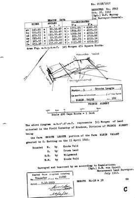 Surveyor-General diagram, 2118/1912, July 1912
10TVVF01.jpg
Cadastre
Surveyor-General diagram index for this parcel
Surveyor-General diagram index for the whole farm — where the original survey of this ground sits.
Research notes
[5 Aug 2026 inbox] Portion 5 of Klein Valie No. 182, NAMED GROOTE LEEGTE. Diagram 2118/1912 (K.M. von OppellM, July 1912), Field-Cornetcy of Kredouw. Figure a.b.c.d.e.f measures 345 morgen 476 square roods; the diagram a.b.c'.d'.e.f represents 513 morgen. Bounded N by Koude Veld; S by Crown Land; SE by Wilgemond; NW by Koude Veld. Deducted No. 2862, 28 Oct 1912. Copied from the diagram relating to Transfer 11090 dated 8.10.1919. NOT THE SAME PARCEL AS PORTION 8, which is named GROOTLEEGTE - see that row. EXTENT CORRECTED 5 Aug 2026, same two-figure trap as Portion 1: 'Area Fig. a.b.c.d.e.f. 345 Morgen 476 Square Roods' is von Oppell's survey; the '513 Morgen' in the body is the primed figure a.b.c'.d'.e.f, the older line. The modern polygon measures 296.4 ha against 295.9 ha for 345 mg 476 sr - agreement to 0.2%.
[13 Aug 2026] Renamed to the one form this model uses for every portion - the portion's own name, then the parent farm, its number and the portion in brackets - so that a name is legible in a list, a search result and a map popup without the reader having to know which farm number is which. It read "Groote Leegte (Klein Valie Ptn 5)" before. Nothing about the ground changed.
The research behind this page, kept separate from it: dated working notes, open questions, and what is not yet settled.
What the record is missing
-
Nobody is on record as ever having held this
third order · B8 never-held
Groote Leegte (Klein Valie No. 182 Ptn 5) is in the model and drawn on the map, and carries no ownership record of any kind, not a grant, not a transfer, not an occupation.
What would settle it The Surveyor-General's diagram for the farm number names the grantee and the date; the deed reference on it opens the transfer chain.
Found by breaks.py reading the model against itself, not written by hand,
each one is a shape of missing record, not a fault in the data.
The whole set is on the
questions page.