Abrahams Kraal
29 on the cadastre · on record 1912 · show on the map
- Farm number
- No. 29
- On the cadastre
- 29, whole farm
- District
- Prince Albert
- Extent, as the diagram states it
- 12697 morgen
- Modern surveyed area
- 9060.3 ha
The historic extent and the modern surveyed area are two separate measurements and are not presented here as confirming each other. The first is what a surveyor wrote on a diagram, usually in morgen. The second is what the modern cadastre draws.
Why this farm is here
Named on the boundary of ground we hold, the neighbours are how the district describes itself. 69 km from Klaarstroom.
- border Shares a boundary with Varsche Fontein Varsche Fontein
- border Shares a boundary with Groot Rivier (Varsche Fontein No. 27 Ptn 2) Groot Rivier (Varsche Fontein No. 27 Ptn 2)
- border Shares a boundary with Jan Willems Fontein No. 32 Jan Willems Fontein No. 32
- border Shares a boundary with Bokfontein No. 94 (formerly Waterfall) Bokfontein No. 94 (formerly Waterfall)
- …and 1 more, listed in full further down this page.
What the record holds, in order
- December 1912 document SG diagram
Bordered by, as the diagram names them
- E Varsche Fontein
- N Kruid Fontein
- N Jan Willems Fontein
- S Blaauw Krants
Also bordered by, as the modern cadastre draws it
Ground that touches this farm on the Surveyor-General's current polygons and that none of the diagrams held here names. Derived from the geometry, not read off a document.
- N Kruitfontein No. 33
- E Plaat Fontein (Varsche Fontein No. 27 Ptn 3)
- SE Groot Rivier (Varsche Fontein No. 27 Ptn 2)
- S Blaauwkranse No. 30
- S Bloukrans No. 31
- NW Rietfontein No. 56
Documents
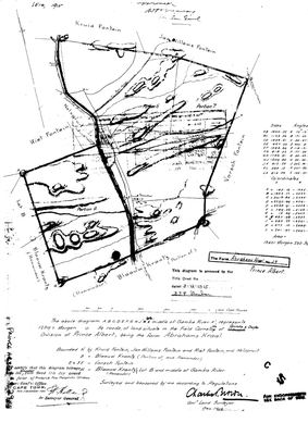 Surveyor-General diagram, December 1912
10122612.TIF
Cadastre
Surveyor-General diagram index for this parcel
Research notes
Western neighbour of Varsche Fontein. Field Cornetcy of Gamka & Gouph. Surveyed Dec 1912 by Charles Brown; title 3 Dec 1915. Bounded N Kruid Fontein/Jan Willems Fontein/Riet Fontein/Nelspruit, S Blaauw Krants, E & SE Varsch Fontein, W Blaauw Krantz Lot B and the middle of the Gamka River.
*** [4 Aug 2026] FARM NUMBER CORRECTED, 23 -> 29, AND THE FARM IS NOW ON THE MAP. *** THIS ROW HAD SAID FARM 23 AND NOTHING SUPPORTS THAT: there is no farm 23 in the Prince Albert cadastre we already hold, so the matcher could never find a polygon and the page told readers the location was unknown. It was not unknown; it was mis-numbered, and the polygon has been sitting in geo/prince_albert_farms.geojson all along - the same failure as PAR-000098, where both Sleutelfontein farms were already drawn while a name-only row said otherwise. THREE INDEPENDENT CHECKS BEFORE CHANGING IT, none of them the name alone: (1) the cadastre names farm 29 ABRAHAMS KRAAL and holds no farm 23 at all; (2) farm 29's polygon TOUCHES Varsche Fontein No. 27 - nearest edges 0,00 km - and this row's own note, written from the 1912 diagram, says it is bounded 'E & SE Varsch Fontein'; (3) farm 29's centroid lies WEST of farm 27's, which is what 'Western neighbour of Varsche Fontein' requires. STILL OPEN: whether DOC-0031 (surveyed Dec 1912 by Charles Brown, titled 3 Dec 1915) is a survey of the WHOLE farm or of a portion. It is matched to the whole farm, 9 067,5 ha, because the boundary list on it reads as a whole-farm description; farm 29 does carry portions in the cadastre, including the 15/29 Frans had selected. [TO VERIFY]
The research behind this page, kept separate from it: dated working notes, open questions, and what is not yet settled.
Open questions
-
Substituting Diagram 2014/1921 cancelled the 1834 grant of Jan Willems Fontein, and the farm grew by a quarter
priority 2 · LEAD-0146
S.G. Dgm 354/1834 gives Jan Willems Fontein No. 32 as 7,059 morgen, about 6,046 ha. The modern whole-farm polygon is 7,703.6 ha. The 1834 sheet is stamped CANCELLED, vide Subst. Dgm 2014/1921, D/T 1922-50-2887. What did the 1921 resurvey do, and where did the extra ground come from?
What would settle it Diagram 2014/1921, which will state the resurveyed extent and name what was taken in.
What the record is missing
-
“Kruid Fontein” is named as a neighbour 2 times and we hold no parcel for it
third order · B3 unheld-farm
2 separate surveys in this model put Kruid Fontein on the boundary of ground we do hold (PAR-000030, PAR-000126). It has no parcel of its own here, so nothing is known about who held it or when, while it borders farms at the centre of the project.
What would settle it The Surveyor-General's farm index for the registration division will give it a farm number and a diagram; the cadastre pull in `data/fetch_cadastre.py` then places it on the map.
-
Nobody is on record as ever having held this
third order · B8 never-held
Abrahams Kraal is in the model and drawn on the map, and carries no ownership record of any kind, not a grant, not a transfer, not an occupation.
What would settle it The Surveyor-General's diagram for the farm number names the grantee and the date; the deed reference on it opens the transfer chain.
Found by breaks.py reading the model against itself, not written by hand,
each one is a shape of missing record, not a fault in the data.
The whole set is on the
questions page.