Surveyor-General diagram, 765/1873, 1872
Surveyor-General diagram, 1872
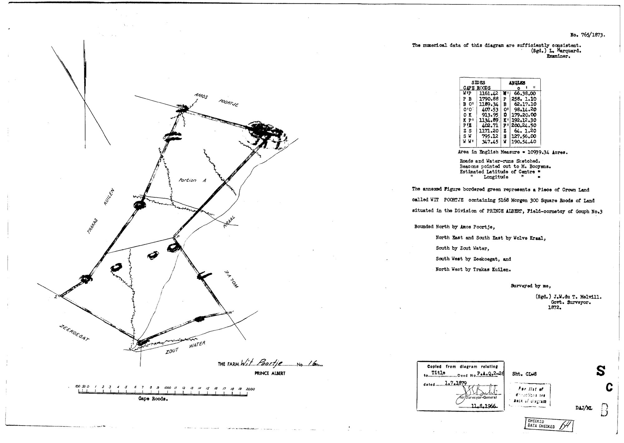
10FKU101 16 0.jpg.The record
- Type
- Surveyor-General diagram
- Diagram number
- 765/1873
- Surveyed
- 1872
- Titled
- 1 July 1879
- Deed
- P.A.Q.2-26
- Surveyor
- J.W. du T. Melvill
- Examiner
- L. Marquard
- Archive filename
- 10FKU101 16 0.jpg
Citation
- Title
- The farm Wit Poortje No. 16, Prince Albert - SG diagram 765/1873 and its verso deduction table
- Repository
- Surveyor-General, Cape Town (via the Chief Surveyor-General's e-SIO)
- Reference
- SG 765/1873; Title Deed P.A.Q.2-26 of 1 July 1879; Sht. CL-8
- Type
- survey diagram
- Retrieved
- 2026-08-09
The ground it is about
Research notes
[9 Aug 2026] FACE READ. Caption verbatim: "The annexed Figure bordered green represents a Piece of Crown Land called WIT POORTJE containing 5168 Morgen 300 Square Roods of Land situated in the Division of PRINCE ALBERT, Field-cornetcy of Gouph No.3". Bounded North by Amos Poortje, North East and South East by Wolve Kraal, South by Zout Water, South West by Zeekoegat, and North West by Trakas Kuilen. "Surveyed by me, (Sgd.) J.W. du T. MelvillM. Govt. Surveyor. 1872." Examiner: "The numerical data of this diagram are sufficiently consistent. (Sgd.) L. MarquardM." Ten beacons W', P, B, O', O, K, P', Z, S, W with sides in Cape roods and angles tabled. "Roads and Water-runs Sketched. Beacons pointed out to M. Booyens." Copy stamp: "Copied from diagram relating to Title Deed No. P.A.Q.2-26 dated 1.7.1879", re-stamped for the Surveyor-General 11.8.1966. Sht. CL-8. "For list of deductions see back of diagram", which is DOC-0259.
IT STATES ITS AREA TWICE, IN TWO UNITS, AND THEY AGREE. "Area in English Measure = 10939.34 Acres" against 5168 morgen 300 roods, which is 10,939.32 acres: 0.0002% apart.
THE FORM ASKS FOR CO-ORDINATES AND THEY ARE BLANK. "Estimated Latitude of Centre =" and "Longitude =" are printed on the sheet with nothing written after either. In 1872 the farm was fixed by its neighbours and its beacons, and by nothing else.
The research behind this page, kept separate from it: dated working notes, open questions, and what is not yet settled.