Surveyor-General diagram, 4933/1934, July 1934
Surveyor-General diagram, July 1934
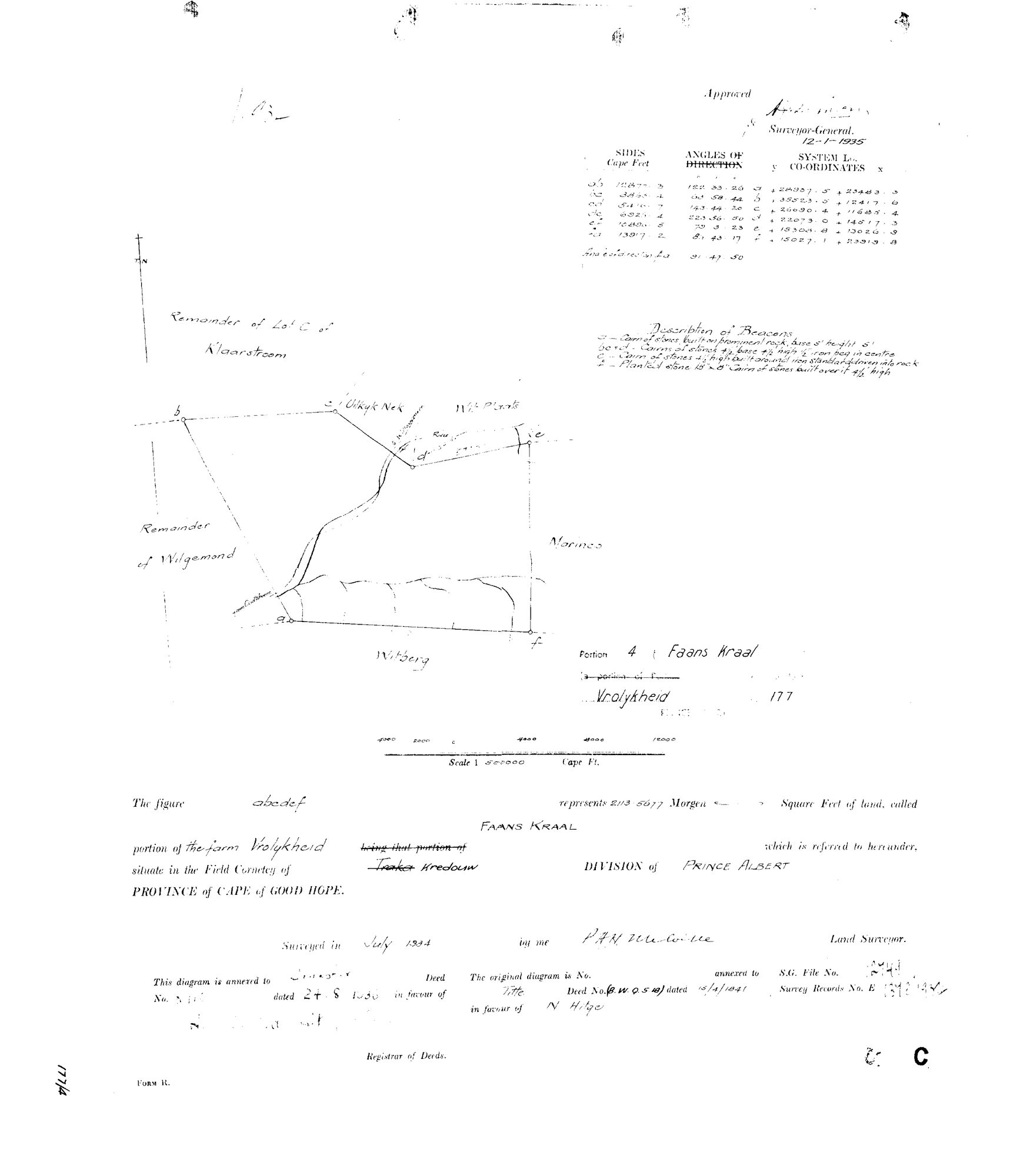
10X2V901.TIF.The record
- Type
- Surveyor-General diagram
- Diagram number
- 4933/1934
- Surveyed
- July 1934
- Titled
- 24 August 1936
- Deed
- 8110
- Surveyor
- P.A.H. Melville (signature, reading uncertain)
- Archive filename
- 10X2V901.TIF
Citation
- Title
- Vrolykheid Portion 4 "Faans Kraal" diagram
- Repository
- Surveyor-General
- Reference
- SG Dgm 4933/1934
- Type
- SG diagram
The ground it is about
Faans Kraal (Vrolikheid No. 177 Ptn 4) 4/177
Research notes
"Portion 4 (Faans Kraal), a portion of Vrolykheid No.177, Prince Albert." Field Cornetcy given as Traka, struck through and corrected in hand to Kredouw - same correction as DOC-0068/DOC-0069. Surveyed July 1934, approved by the Surveyor-General 12-1-1935. Extent 213.5677 morgen [CONFIRMED 29 Jul 2026: DOC-0028's verso, re-read, gives Faans Kraal 177/4 exactly 213.5677mg - the model's earlier 213.9677 was the verso misread, now corrected in parcels.csv]. "This diagram is annexed to Transfer Deed No. 8110 dated 24.8.1936" - matches parcels.csv's own pre-existing note (SG Dgm 4933/1934; deed 24.8.1936-8110) and DOC-0028's verso deductions summary for Marinco/Faans Kraal/Lot A exactly, unlike the Marinco/DOC-0068 conflict. The grantee's name on this diagram's own transfer line is illegible on the scan; attributed to V.C. Marincowitz (PER-000045) on the strength of the deed/date match with DOC-0028 and the family pattern (same buyer as Uitkyk Nek and Marinco) - confidence held at high since no conflicting reading exists, but the name itself was not read directly off this scan. "The original diagram is No. [blank] annexed to Title Deed No. (B.W.Q.5.18) dated 15/4/1841 in favour of N. HitgeM" - a THIRD Vrolykheid portion citing the Hitge title rather than the Oosthuisen grant; see DOC-0068/DOC-0069/PAR-000014 notes for the open question this raises. Surveyor signature reads approximately "P.A.H. Melville" - possibly the same hand as DOC-0068/DOC-0069's "J.A.H. Melville", reading uncertain both times, not asserted as the same or a different person. Neighbours shown on this diagram: Uitkyk Nek (PAR-000032), Wit Plaats (PAR-000031), Marinco (PAR-000035), Remainder of Wilgemond, Remainder of Lot C of Klaarstroom, Witberg.
[3 Aug 2026] publish_ok=yes. This is an OLD FARM DIAGRAM held back only because a TRANSFER ENDORSEMENT on its face crosses the 1936 scan cut-off - the survey itself is from the 1920s or 1930s. The names on it are the surveyor, the neighbouring farms and a transferee of the 1930s or 1940, all long dead and most of them already published as person records here. Reviewed individually, not opened as a category.
The research behind this page, kept separate from it: dated working notes, open questions, and what is not yet settled.