Surveyor-General diagram, 349/1833, August 1833
Surveyor-General diagram, August 1833
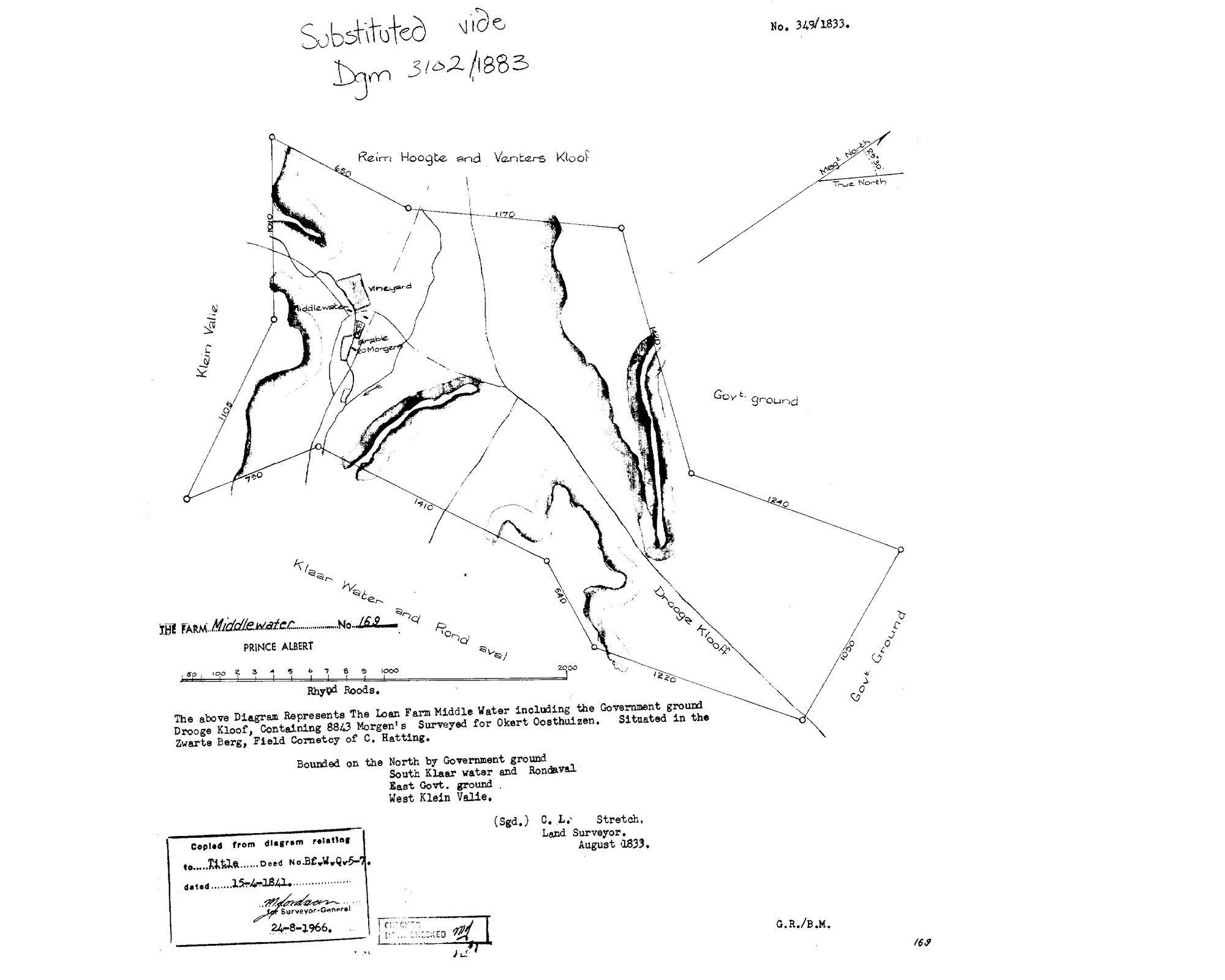
10JCGZ01.TIF.The record
- Type
- Surveyor-General diagram
- Diagram number
- 349/1833
- Surveyed
- August 1833
- Titled
- 15 April 1841
- Deed
- Bf.W.Q.5-7
- Surveyor
- C.L. Stretch
- Archive filename
- 10JCGZ01.TIF
Citation
- Title
- Middelwater No.169 original loan-farm diagram (1833)
- Repository
- Surveyor-General
- Reference
- SG Dgm 349/1833
- Type
- SG diagram
The ground it is about
Middelwater 169
Research notes
"The LOAN FARM Middle Water including the Government ground DROOGE KLOOF, containing 8843 Morgens, Surveyed for OKERT OOSTHUIZEN. Situated in the Zwarte Berg, Field Cornetcy of C. HattingM." Bounded N Government ground, S Klaar water and Rondewal, E Govt ground, W Klein Valle. Substituted vide Dgm 3102/1883 - which is the parent diagram the 1883 resurvey referenced. [29 Jul 2026] A clearer copy of the same scan (10JCGZ01) arrived via chat and is filed alongside as DOC-0038-middelwater-no169-original-1833-clear.jpg. On it the 1966 copy-stamp is legible: "Copied from diagram relating to Title Deed No. Bf.W.Q.5-7, dated 15-4-1841" - MIDDELWATER'S 1841 DEED IS Bf.W.Q.5-7, sitting in the same 15 April 1841 volume-5 run as De Aar (5-6), Venters Kloof (5-14), Klaarstroom (5-17), Vrolykheid/Hitge (5-18) and Oorlogs Kloof (5-30). Face also legible: the werf ("Middelwater"), a VINEYARD and "arable 20 Morgens" are drawn on the Klein Valie side of the farm - the same quarter where the 1883 resurvey (DOC-0001) marks the VASTE WATER spring. See PAR-000040: the werf-at-the-spring may be the very piece cut out for Susanna Maria KlueM in 1923 (Klueplaas) [TO VERIFY].
The research behind this page, kept separate from it: dated working notes, open questions, and what is not yet settled.