Welbedagt Nr. 555
· op rekord 1823–2013 · wys op die kaart
- Plaasnommer
- Nr. 555
Hierdie perseel het geen gepaste opmetingspoligoon nie, en kan dus nie op die kaart geteken word nie. Dit is 'n gaping in die kadasterpassing, nie 'n afwesigheid uit die rekord nie.
Waarom hierdie plaas hier is
Carel Aaron van der Merwe (1771-1850) het dit gehou. Nog nie op die kaart geplaas nie.
Carel Aaron van der Merwe (1771-1850) is regstreeks op hierdie grond aangeteken. Geen spoor nodig nie.
- dokument 'n Dokument in die versameling beskryf hierdie grond DOC-0291
- dokument 'n Dokument in die versameling beskryf hierdie grond DOC-0292
Wat die rekord hou, in volgorde
-
2 Junie 1823
document
SG diagram 114/1823
grondbrief Clw. Q. 1-15
-
2 Junie 1823
ownership
Carel Aaron van der Merwe (1771-1850) (1771–1850)
erfpacht · survey · confidence high
- 2013 document SG diagram verso 114/1823 (verso)
Begrens deur, soos die kaart hulle noem
- N Hantamsberg, and government ground measured in erfpacht for Hendk. Johs. Visagie
- NE a wide expanse of waste government ground ("eene wyd uitgestrektheid woest gouvts. grond")
- E the Hantam's berg
- S the Hantam's berg
- SW the place given out in erfpacht marked karre houte boom
Dokumente
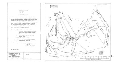 Landmeter-generaal-kaart, 114/1823, 2 Junie 1823
10053943 555.jpg
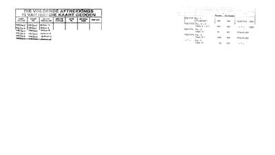 Kaart se keersy, 114/1823 (verso), 2013
10053944 555.jpg
Navorsingsnotas
[11 Aug 2026, SRC-404, SRC-405, SRC-406] THE FARM JACOBUS ALEWYN VAN DER MERWE WAS KNOWN BY. He is recorded as "KWAAI KOOS WELBEDACHT"; his daughter Elsje Johanna was BORN here on 31 March 1835 and MARRIED here on 27 December 1854, and his wife Elisabeth Maria TheronM DIED here on 31 January 1855. Three events and a man's byname on one piece of ground that this project had never entered. IDENTIFIED BY ELIMINATION AND BY PROXIMITY, WHICH IS NOT THE SAME AS PROOF. The Calvinia cadastre holds exactly ONE farm whose name begins WELBED: no. 555, WELBEDAGT. It lies 26.9 km from Tygerhoek and 59.7 km from Oude Muur, which is the same country the rest of this branch held. The CSG name index also returned a WELBEDACHTE No. 611 in Calvinia, which does not appear in the division's own cadastre file under that name and was probably a compound-name artefact of that search; and two Welbedachts in CLANWILLIAM, Nos. 537 and 139. The 1854 marriage register says "parochie van Calvinia, distrikt van Clanwilliam", which in 1854 is not a contradiction - Calvinia was a parish inside Clanwilliam - so the register does not choose between the divisions for us. NO DOCUMENT YET PUTS A VAN DER MERWE ON THIS TITLE. That is what LEAD-0169 is for, and it is why this row says identified rather than proven. Polygon and centroid from the CSG cadastre.
Werknotas, hier gewys omdat dit 'n private navorsingsbou is.
Die werksnotas op hierdie werf word in Engels gehou en word nie vertaal nie. Hulle verander met elke navorsingsessie, en 'n vertaling sou uit pas raak met die oorspronklike. Alles anders — die stories, die getranskribeerde dokumente en die koppelvlak — is in Afrikaans.
Oop vrae
-
Read the diagrams for Brasse Fontein 371 and Welbedagt 555
prioriteit 2 · LEAD-0172
Five SG diagrams are in the inbox unread: 10051901 and 10051902 for farm 371 in two parts, 10052409 for 371, and 10053943 and 10053944 for Welbedagt 555. Do any of them name a van Wyk, a Nel or a van der Merwe on the title or a boundary?
Wat dit sou uitmaak A van Wyk on the title of 371, or a van der Merwe on 555.
Wat die rekord kortkom
-
The record stops in 1823 and never resumes
second order · B2 trail-ends
Welbedagt Nr. 555 was worked as far as 1823-06-02, with Carel Aaron van der MerweL (1771-1850) the last owner on record. 203 years follow with nothing. Who held it after that, and is it still one farm?
What would settle it The current title deed traced backwards, each transfer names the one before it, or the Surveyor-General's subdivision diagrams, which are what usually explain a farm going quiet.
-
“the Hantam's berg” is named as a neighbour 2 times and we hold no parcel for it
third order · B3 unheld-farm
2 separate surveys in this model put the Hantam's berg on the boundary of ground we do hold (PAR-000199). It has no parcel of its own here, so nothing is known about who held it or when, while it borders farms at the centre of the project.
What would settle it The Surveyor-General's farm index for the registration division will give it a farm number and a diagram; the cadastre pull in `data/fetch_cadastre.py` then places it on the map.
Found by breaks.py reading the model against itself, not written by hand,
each one is a shape of missing record, not a fault in the data.
The whole set is on the
questions page.