Zeekoegate
22 op die kadaster · op rekord 1936–2022 · wys op die kaart
- Plaasnommer
- Nr. 22
- Op die kadaster
- 22, heel plaas
- Distrik
- Prince Albert
- Moderne opgemete oppervlakte
- 5711.7 ha
1 inskrywing hieronder noem 'n party wat leef, of wat nie as oorlede aangetoon kan word nie. Die transaksie word gewys; die naam nie.
Waarom hierdie plaas hier is
Martha Maria Susanna Oosthuizen lê hier begrawe. 32 km van Klaarstroom.
Martha Maria Susanna Oosthuizen is regstreeks op hierdie grond aangeteken. Geen spoor nodig nie.
- storie 'n Geskrewe geskiedenis speel op hierdie grond af The church at Zeekoegat
- storie 'n Geskrewe geskiedenis speel op hierdie grond af The French Observatory
- storie 'n Geskrewe geskiedenis speel op hierdie grond af Eighty-one thousand morgen
- perseel Consolidated into: Plaas 222
- …en nog 2, volledig gelys verder af op hierdie bladsy.
Stories
- set here
Die kerkie op Zeekoegat
Drie geslagte Oosthuizens in die Zwartberg-gemeente, en die welgestelde boer wat op sy eie grond, 65 km ver op die grondpad, vir honderd mense 'n kerkie gebou het.
- about this farm
Die Franse Sterrewag
Ses Europese lande soek sewe jaar lank na 'n suidelike hemel, bou 'n werkende sterrewag op 'n skaapplaas by Zeekoegat, en gaan dan Chili toe. Dit is die derde keer dat die buitewêreld na hierdie een plaas kom vir iets wat dit nêrens anders kry nie - ná die goud en die fossiele - en die derde keer was die antwoord weer amper.
- about this farm
Een-en-tagtig duisend morg
Frederik Simon 'Oom Frikkie' Oosthuizen sterf in 1936 met, volgens een weergawe, 81 000 morg om Zwartkraal, omtrent 'n kwart van al die grond op hierdie kaart. Hierdie projek besit nie een akte op sy naam nie. Waarin die geld waarskynlik gesit het, waarin dit beslis nie gesit het nie, en watter een dokument die saak sou uitmaak.
Wat die rekord hou, in volgorde
-
10 Oktober 1936
burial
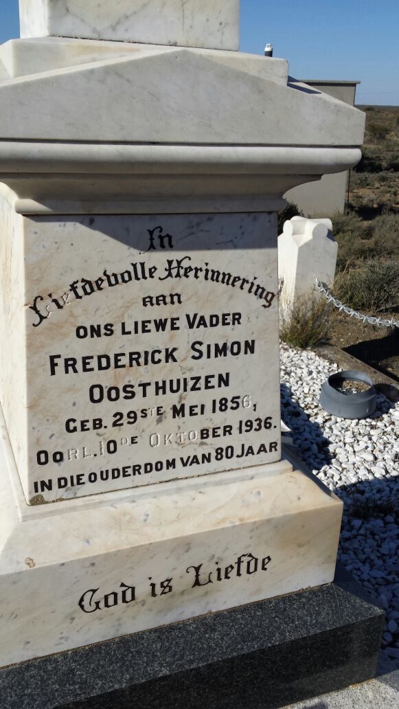
Frederik Simon Oosthuizen (29 Mei 1856–10 Oktober 1936)
Zeekoegat church, In Liefdevolle Herinnering aan ONS LIEWE VADER FREDERICK SIMON OOSTHUIZEN, GEB. 29ste MEI 1856, OORL. 10de OKTOBER 1936, IN DIE OUDERDOM VAN 80 JAAR. On the base below: GOD IS LIEFDE.
-
1936
burial
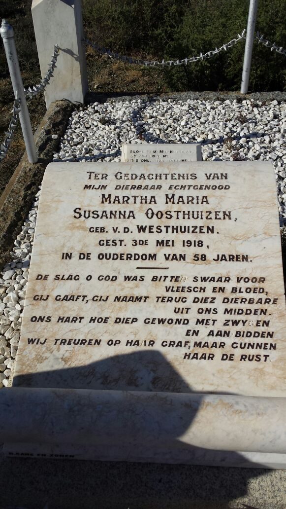
Martha Maria Susanna Oosthuizen (1859–3 Mei 1918)
Zeekoegat church, Ter Gedachtenis van mijn dierbaar echtgenood MARTHA MARIA SUSANNA OOSTHUIZEN, geb. v.d. WESTHUIZEN, GEST. 3de MEI 1918, IN DE OUDERDOM VAN 58 JAREN. Then: 'De slag o God was bitter swaar voor vleesch en bloed, Gij gaaft, Gij naamt terug diez dierbare uit ons midden. Ons hart hoe diep gewond met zwygen en aan bidden, wij treuren op haar graf, maar gunnen haar de rust.' A maker's mark is cut on the kerb below and is not legible in this photograph.
-
1936
burial
Hendrik Oosthuizen (infant) (19 Oktober 1883–8 Desember 1884)
Zeekoegat church
- 21 September 1948 boundary change consolidated into: becomes Leeukraal Nr. 24 (consolidated)
- 2003 boundary change consolidation: becomes Plaas 222
-
die 2020s
ownership
1 party/parties held back by the publishing rule
owner · confidence medium
- 2022 document local history
Op hierdie grond begrawe
- Zeekoegat-kerk 3 grafte opgeteken, 3 in hierdie projek geïdentifiseer · nog geen koördinaat nie
Die begrafnisse verskyn ook op hierdie plaas se tydlyn hierbo, elkeen op sy eie datum.
Foto's
Ook begrens deur, soos die moderne kadaster dit teken
Grond wat aan hierdie plaas raak op die Landmeter-generaal se huidige poligone en wat geen kaart wat hier gehou word, noem nie. Afgelei uit die meetkunde, nie van 'n dokument afgelees nie.
- N Leeukraal Nr. 24 (consolidated)
- N Antjiesfontein (Leeukraal Nr. 24 Gdlt 1)
- N Trakas Kuilen Nr. 15
- NE Wit Poortje Nr. 16
- E Klipgat Nr. 114
- E Zoutwater (Klipgat Nr. 114 Gdlt 1)
- E Bontwater (Klipgat Nr. 114 Gdlt 8)
- S Modderdrift Nr. 106
- S Modderdrift Nr. 106 Gdlt 1
- S Modderdrift Nr. 106 Gdlt 4
- S Modderdrift Nr. 239
- W Plaas 222
Dokumente
ZeekoegatCameo.pdf
Kadaster
Die Landmeter-generaal se kaartindeks vir hierdie perseel
Navorsingsnotas
Frederik Simon OosthuizenH built the church here 1906; modern owner Oosthuizen F.S.
[1 Aug 2026, SRC-068] Three separate times the outside world came to this farm for something it could not get elsewhere: GOLD in 1871 and again in 1891, FOSSILS through Roy Oosthuizen's museum, and STARS, the European Southern Observatory built a working observatory here in 1958-61 (EVT-000238) before choosing Chile. Zeekoegat itself was also prospected in 1891 (EVT-000230). The cameo's own framing: "A tiny church is central to the story, and so are fossils, stars and even a ghost."
[3 Aug 2026, SRC-204] The 2003 consolidation LG 4295/2003 (DOC-0170) takes GEDEELTE 1 (ZEEKOEGAT) of this farm into DIE PLAAS NR 222 (PAR-000136), and in doing so names the portion's diagram - KAART 3557/1910, written over a struck-out 1457/1910 - and its grant, GRONDBRIEF NR P.A.Q. 6-6. WORTH SEEING TOGETHER: Spreeufontein's remainder is granted on P.A.Q. 6-1 and this on P.A.Q. 6-6 - the same grant volume, six entries apart. Two farms this project is built on were granted out of one book. [TO VERIFY against the grants, which are not held.]
[3 Aug 2026, SRC-227] A SWANEPOEL HELD PART OF IT FROM 1867. The 1912 diagram for Zout Water on Klipgat gives its western boundary as "Portion ZEEKOE GAT transferred to P.J. SWANEPOEL 30.7.1867". This model has no ownership span, portion or document recording that, and 9a keeps the Swanepoels in as a block. Which P.J. Swanepoel is not established. [TO VERIFY]
[SRC-327, 7 Aug 2026] A FARM CEMETERY IS RECORDED ON THIS GROUND BY eGGSA: 'Zeekoegate 22, Moeite Verniet', Cemetery ID 7517, at -33.031217, 22.466133. Photographs and captions at https://graveswcape.eggsa.org/PRINCE-ALBERT-Rural/0523002%20Moeite%20Verniet%20by%20Zeekoegat%20_Pieter%20Olckers/ - linked, not copied.
Werknotas, hier gewys omdat dit 'n private navorsingsbou is.
Die werksnotas op hierdie werf word in Engels gehou en word nie vertaal nie. Hulle verander met elke navorsingsessie, en 'n vertaling sou uit pas raak met die oorspronklike. Alles anders — die stories, die getranskribeerde dokumente en die koppelvlak — is in Afrikaans.
Oop vrae
-
Where did Frikkie's money come from
prioriteit 2 · LEAD-0012
What built Frederik Simon OosthuizenH's (PER-000006) 81,000-morgen fortune around Zwartkraal?
Wat dit sou uitmaak The 1936 estate inventory - it would list every farm with its purchase deed, date and value, i.e. the whole accumulation history in one document
Wat die rekord kortkom
-
A tenure with no one in it
second order · B7 no-owner
OWN-000009 records a owner on Zeekoegate from 202X and names no party. Either the holder was never read off the document, or the publishing rule withheld them, the page cannot tell you which, and neither can this.
What would settle it There is no document on this span either; it wants one.
Found by breaks.py reading the model against itself, not written by hand,
each one is a shape of missing record, not a fault in the data.
The whole set is on the
questions page.