Matjesfontein No. 601
· on record 1823 · show on the map
- Farm number
- No. 601
- Extent, as the diagram states it
- Grazing Ground 8778 Morgen 189 Square Roods; Government Ground 5784 Morgen 193 Square Roods
This parcel has no matched survey polygon, so it cannot be drawn on the map. That is a gap in the cadastre match, not an absence from the record.
Why this farm is here
Described by a document in this collection. Not yet placed on the map.
- document A document in the collection describes this ground DOC-0288
What the record holds, in order
-
1823
document
SG diagram 124/1823
Clw. Q. 1-37
Bordered by, as the diagram names them
- NW waste government ground
- NE Wid. Johs Louw J.G. Son (government ground requested for)
- E E. A. Nel A son (government ground requested for)
- SE Sybrand Straus J.M. Son (government ground requested for)
- S Johannes Matts Straus K. Senior (ground requested for)
- W David Josephus Straus J.M. Son (government ground requested for)
Documents
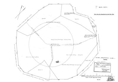 SG diagram, 124/1823, 1823
10054381 601.jpg
Research notes
[11 Aug 2026, SRC-387] ENTERED AS A CANDIDATE, NOT AS FAMILY GROUND. This is the nearest of the seven Calvinia farms called Matjesfontein to the ground this family actually held - 14.9 km from Oude Muur - and LEAD-0151 asks whether one of them is the farm PER-000762 was born on in 1863. NOTHING ON THE DIAGRAM CONNECTS IT TO THIS FAMILY. The boundary annotations name three Strausses, a Nel and a Louw widow, and no van der Merwe. That is evidence but not a disproof: the sheet describes the 1820s and 1830s and the birth is forty years later. THE DIAGRAM ALSO WARNS AGAINST ITSELF. A road leaving the south-west corner is labelled "Road to the place Matjes fontein of J. M. Straus", so a SECOND Matjesfontein lay within a few kilometres of this one and was not this one. Two more of the fountain notes point at a third, "Naresie Matjesfontein". The name was local currency here. Centroid from the CSG cadastre, not from the diagram.
The research behind this page, kept separate from it: dated working notes, open questions, and what is not yet settled.
Open questions
-
The Hantam ground has no basemap under it
priority 3 · LEAD-0167
The Calvinia farms are on the map as polygons but sit over blank canvas, and the four Northern Cape cemeteries have no pins at all. What is missing, and is it worth fetching?
What would settle it A re-cut basemap covering the Hantam, and a sourced coordinate for each town cemetery.
What the record is missing
-
“E. A. Nel A son (government ground requested for)” held ground next door and we have no tenure for them
first order · B4 unheld-owner
A boundary description for Matjesfontein No. 601 names E. A. Nel A son (government ground requested for), a surveyor stating on the record that this person held the adjoining ground. No one of that surname holds a single ownership span anywhere in this model.
What would settle it The diagram's own date fixes the window. The quitrent or erfpacht register for that year names the holder of the adjoining place, and an estate inventory will name the farm outright.
-
“Wid. Johs Louw J.G. Son (government ground requested for)” held ground next door and we have no tenure for them
third order · B4 unheld-owner
A boundary description for Matjesfontein No. 601 names Wid. Johs Louw J.G. Son (government ground requested for), a surveyor stating on the record that this person held the adjoining ground. We do hold Louw tenure elsewhere, but none on this boundary and none at this date.
What would settle it The diagram's own date fixes the window. The quitrent or erfpacht register for that year names the holder of the adjoining place, and an estate inventory will name the farm outright.
-
Nobody is on record as ever having held this
third order · B8 never-held
Matjesfontein No. 601 is in the model, and carries no ownership record of any kind, not a grant, not a transfer, not an occupation.
What would settle it The Surveyor-General's diagram for the farm number names the grantee and the date; the deed reference on it opens the transfer chain.
Found by breaks.py reading the model against itself, not written by hand,
each one is a shape of missing record, not a fault in the data.
The whole set is on the
questions page.