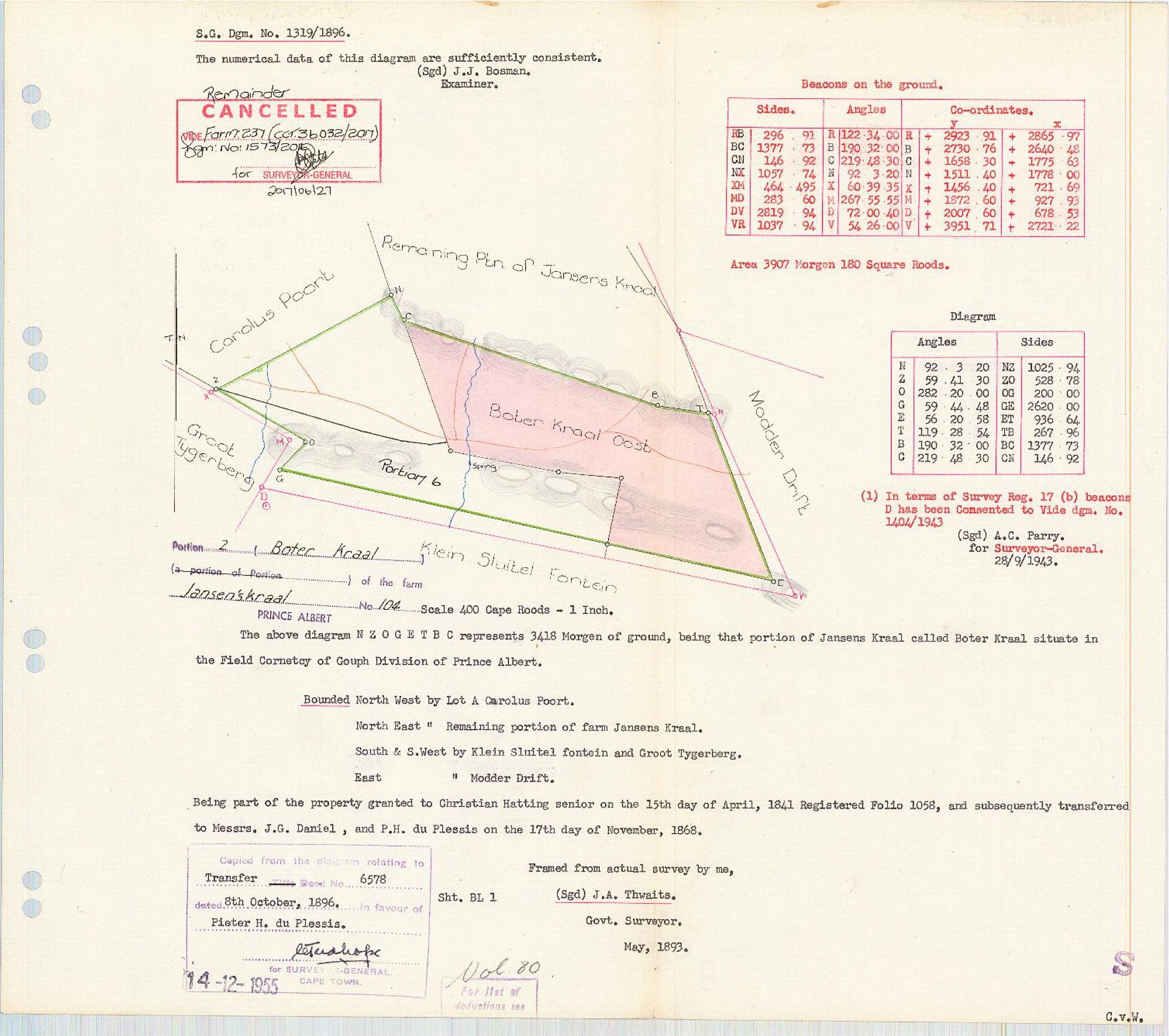
Surveyor-General diagram, 1319/1896, May 1893
Surveyor-General diagram, May 1893
11414737.The record
- Type
- Surveyor-General diagram
- Diagram number
- 1319/1896
- Surveyed
- May 1893
- Titled
- 8 October 1896
- Deed
- Transfer 6578 of 8.10.1896
- Surveyor
- J.A. Thwaits
- Examiner
- J.J. Bosman
- Archive filename
- 11414737
Citation
- Title
- S.G. Diagram 1319/1896, Portion 2 (Boter Kraal) of Jansenskraal No. 104, Prince Albert
- Repository
- Surveyor-General, Cape Town (Western Cape)
- Reference
- S.G. Dgm. No. 1319/1896; Vol. 80, Sht. BL 1; sheet marked 104/2
- Type
- SG diagram (original scan)
- Retrieved
- 2026-08-14
The ground it is about
Botterkraal (Jansenskraal No. 104 Ptn 2)
Research notes
3418 morgen, "that portion of Jansens Kraal called BOTER KRAAL", FIELD CORNETCY OF GOUPH, Division of Prince Albert. Framed from actual survey by J.A. Thwaits, Govt. Surveyor, May 1893; examined by J.J. Bosman, "The numerical data of this diagram are sufficiently consistent". Copied from the diagram relating to Transfer Deed No. 6578 dated 8 October 1896 IN FAVOUR OF PIETER H. DU PLESSIS; Surveyor-General Cape Town copy stamp 14-12-1955. Vol. 80, Sht. BL 1.
THE CHAIN OF TITLE IN ONE SENTENCE, AND IT STARTS ON GRANT DAY: "Being part of the property granted to CHRISTIAN HATTING SENIOR on the 15th day of April, 1841 Registered Folio 1058, and subsequently transferred to Messrs. J.G. DANIEL and P.H. DU PLESSIS on the 17th day of November, 1868."
BOUNDED North West by Lot A Carolus Poort; North East by the Remaining portion of farm Jansens Kraal; South and South West by Klein Sluitel fontein and Groot Tygerberg; East by Modder Drift. The map face also labels BOTER KRAAL OOST, PORTION 6 and a SPRING on the western boundary.
Beacons table gives Area 3907 morgen 180 square roods - LARGER than the 3418 morgen in the text, which is the figure to query rather than to average [TO VERIFY].
Note (1): in terms of Survey Reg. 17(b) beacon D consented, vide dgm. No. 1404/1943, signed A.C. Parry for Surveyor-General 28/9/1943.
CANCELLED as to the Remainder, vide Farm 237 (Cert. 36032/2017), dgm. No. 1573/2016, for Surveyor-General 2017/06/27.
The research behind this page, kept separate from it: dated working notes, open questions, and what is not yet settled.