Surveyor-General diagram, 1200/1911, September 1910
Surveyor-General diagram, September 1910
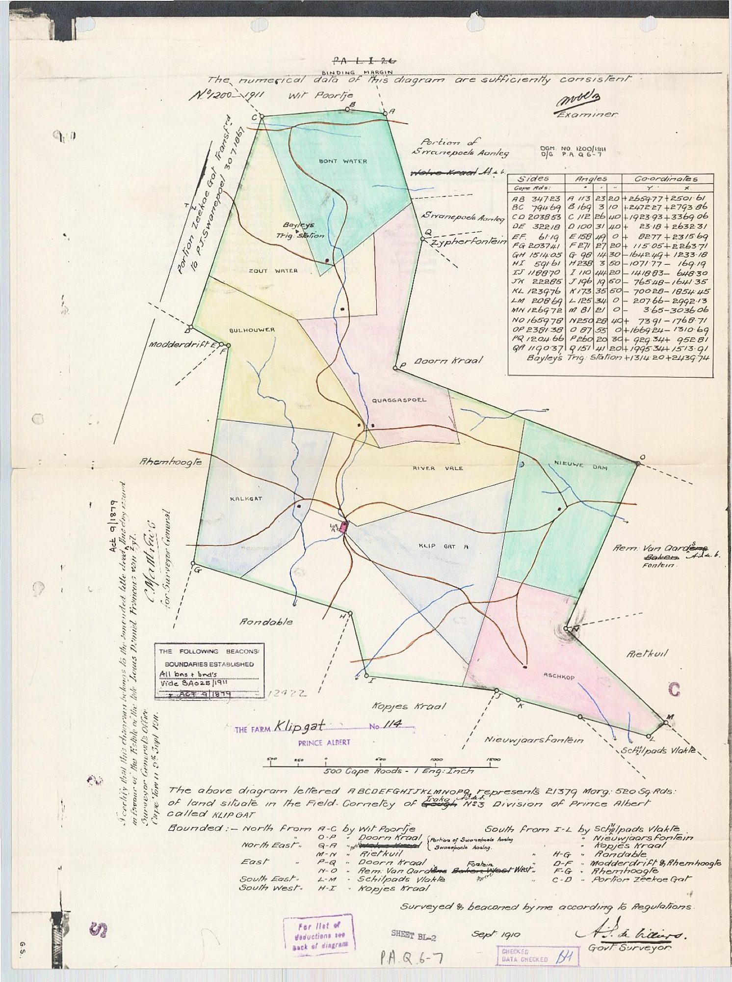
11369058 klipgat.pdf.The record
- Type
- Surveyor-General diagram
- Diagram number
- 1200/1911
- Surveyed
- September 1910
- Titled
- 24 September 1911
- Deed
- D/G P.A.Q 6-7
- Surveyor
- A.J. de Villiers
- Examiner
- (signed, initials only)
- Archive filename
- 11369058 klipgat.pdf
Citation
- Title
- Klipgat No. 114 diagram and reverse, 1910/1911
- Repository
- Surveyor-General
- Reference
- SG Dgm 1200/1911
- Type
- SG diagram
- Retrieved
- 2026-08-01
The ground it is about
Klipgat No. 114 114
Research notes
"THE FARM KLIPGAT No. 114, PRINCE ALBERT." "The above diagram lettered A B C D E F G H I J K L M N O P Q represents 21379 Morg: 520 Sq: Rds: of land situate in the Field-Cornetcy of Traka [STRUCK THROUGH, amended to] Gouph No. 3 Division of Prince Albert called KLIPGAT." "Surveyed & beaconed by me according to Regulations", Govt Surveyor, Sept 1910. Examiner's note: "The numerical data of this diagram are sufficiently consistent." THE TITLE CERTIFICATE, verbatim: "I certify that this diagram belongs to the amended title deed this day issued in favour of the Estate or the late Lucas Daniel Fromon van Zyl. Surveyor General's Office, Cape Town 24 Sept 1911." Marked Act 9/1879. Beacons and boundaries established vide BA 025/1911. Sheet BL-2. BOUNDED: North A-C by Wit Poortje, and O-P by Doorn Kraal; North East Q-A by Swanepoels Aanleg (a prior "Watervals Kraal" struck through, replaced by "Portion of Swanepoels Aanleg"), and M-N by Rietkuil; East P-Q by Doorn Kraal, and N-O by Remainder Van Aardens Fontein (an earlier "Bakens West" struck through); South East L-M by Schilpads Vlakte; South West H-I by Kopjes Kraal; South I-L by Schilpads Vlakte, Nieuwjaarsfontein and Kopjes Kraal; H-G by Rondable; D-F by Modderdrift and Rhemhoogte; F-G by Rhemhoogte; C-D by Portion Zeekoe Gat. A marginal note reads "Portion Zeekoe Gat Transferred to P.J. Swanepoel 30/7/1857". TEN INTERNAL DIVISIONS are drawn and coloured on the face and named: Bont Water, Zout Water, Bulhouwer, Kalkgat, Quaggaspoel, River Vale, Nieuwe Dam, Klip Gat A, Aschkop and Lot A. They are registered in 1916, see the reverse, DOC-0159. CO-ORDINATE TABLE in Cape Roods, beacons A to Q with sides and angles, e.g. AB 3472.23 / A 113 23 20 / +265977 +2501.61. Bayley's Trig Station +1314.20 +2439.74. NOT georeferenced, per 9.
The research behind this page, kept separate from it: dated working notes, open questions, and what is not yet settled.