Matjes Fontein Nr. 712
· op rekord 1885 · wys op die kaart
- Plaasnommer
- Nr. 712
- Distrik
- Calvinia (division)
- Grootte, soos die kaart dit stel
- 10340 morgen 242 sq roods
- Moderne opgemete oppervlakte
- 4450.6 ha
Die historiese grootte en die moderne opgemete oppervlakte is twee aparte metings en word hier nie aangebied asof hulle mekaar bevestig nie. Die eerste is wat 'n landmeter op 'n kaart geskryf het, gewoonlik in morg. Die tweede is wat die moderne kadaster teken.
Waarom hierdie plaas hier is
Grond waarop 'n geskrewe geskiedenis afspeel. 282 km van Klaarstroom.
- storie 'n Geskrewe geskiedenis noem hierdie grond The van der Merwes of the Hantam
- dokument 'n Dokument in die versameling beskryf hierdie grond DOC-0284
Stories
- mentions this farm
Die van der Merwes van die Hantam
Van Frans se vier grootouerlyne was die van der Merwes die laaste om die Prins Albert-distrik te bereik, en hulle het van die verste af gekom. Agt geslagte van 'n doop op die Paarl in 1735 tot Vredendal omstreeks 1950, met 'n opmeting van 1823 wat die trekker self by die naam noem.
Wat die rekord hou, in volgorde
- 1885 document SG diagram 1908/1885
Dokumente
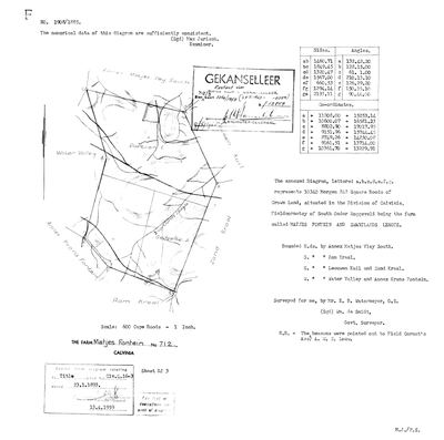 Landmeter-generaal-kaart, 1908/1885, 1885
10055127 712.jpg
Navorsingsnotas
[10 Aug 2026, SRC-370/DOC-0284] WHERE FRANS JACOBUS WILHELMUS VAN DER MERWE WAS BORN, 24 March 1863 (PER-000762). S.G. 1908/1885 calls it 'the farm called MATJES FONTEIN AND ZWARTLANDS LEEGTE', 10340 morgen 242 roods of Crown Land, FIELDCORNETCY OF SOUTH ONDER ROGGEVELD - a third cornetcy, after Tygerhoek's Voor Hantam and Oude Muur's Onder Bokkeveld. Surveyed for Wm. de Smidt by E. B. Watermeyer; examiner Max Jurisch, the same man who examined Middelwater's 1883 resurvey. Beacons pointed out to Field Cornet's Assistant A. W. S. LOUW. Title Clv. Q. 16-3 of 23.1.1893. Bounded N by Annex Matjes Vley South, S by Ram Kraal, E by Leeuwen Kuil and Zand Kraal, W by Water Valley and Annex Krans Fontein. Stamped GEKANSELLEER, superseded by kaart 3256/1958. THE CADASTRE SPELLS IT MATJESFONTEIN, WITHOUT THE I. This project searched for Matjiesfontein and found nothing; the farm was there all along under the other spelling.
[10 Aug 2026] THIS FARM IS NOT ESTABLISHED AS THE BIRTHPLACE. The row was created this morning with a note tying it to PER-000762's birth in 1863; that tie rested on the name and the district and nothing else. There are at least twelve Matjiesfonteins in the Northern Cape, five of them in the FRASERBURG division, and The sheet and the farm are real and stay; the identification is withdrawn. LEAD-0151.
[11 Aug 2026] MEASURED: this farm lies 111.6 km from Oude Muur, which makes it the second furthest of the seven Calvinia Matjesfonteins from the ground this family held. Three others - 601, 791 and 679 - lie within 24 km of Oude Muur. It was entered here because it was the Matjesfontein this project found first, not because anything tied it to the family, and the withdrawn pin stays withdrawn. LEAD-0151.
Werknotas, hier gewys omdat dit 'n private navorsingsbou is.
Die werksnotas op hierdie werf word in Engels gehou en word nie vertaal nie. Hulle verander met elke navorsingsessie, en 'n vertaling sou uit pas raak met die oorspronklike. Alles anders — die stories, die getranskribeerde dokumente en die koppelvlak — is in Afrikaans.
Oop vrae
-
Which Matjiesfontein was Frans Jacobus Wilhelmus van der Merwe born on in 1863?
prioriteit 1 · LEAD-0151
FamilySearch records his birth on 24 March 1863 at 'Matjiesfontein, Calvinia'. The Northern Cape cadastre holds at least twelve farms of that name. Which one, and is it even in the Calvinia division?
Wat dit sou uitmaak A van der Merwe named on the face of one of these 1823 diagrams, or on the boundary list of a neighbour, tying one Matjesfontein to this family rather than to its name.
Wat die rekord kortkom
-
Nobody is on record as ever having held this
third order · B8 never-held
Matjes Fontein Nr. 712 is in the model and drawn on the map, and carries no ownership record of any kind, not a grant, not a transfer, not an occupation.
What would settle it The Surveyor-General's diagram for the farm number names the grantee and the date; the deed reference on it opens the transfer chain.
Found by breaks.py reading the model against itself, not written by hand,
each one is a shape of missing record, not a fault in the data.
The whole set is on the
questions page.