Deel van Klipfontein A Nr. 174
Klipfontein Oost (Klipfontein A Nr. 174 Gdlt 1)
1/174 op die kadaster · op rekord 1938–1939 · wys op die kaart
Die plaas se eie geskiedenis — die toekenning, die oorspronklike opmeting — sit op daardie bladsy.
- Plaasnommer
- Nr. 174
- Gedeelte
- 1
- Ook aangeteken as
- Klipfontein OostDIAGRAM, the sheet reads "Portion 1 (known as KLIPFONTEIN OOST)"KlipfonteinSRC-436, 2023 valuation roll, which prints the parent farm name against this portion
- Op die kadaster
- 1/174, gedeeltegeregistreer as KLIPFONTEIN
- Distrik
- Prince Albert
- Grootte, soos die kaart dit stel
- 2620.9154 morgen
- Moderne opgemete oppervlakte
- 2252.7 ha
Die historiese grootte en die moderne opgemete oppervlakte is twee aparte metings en word hier nie aangebied asof hulle mekaar bevestig nie. Die eerste is wat 'n landmeter op 'n kaart geskryf het, gewoonlik in morg. Die tweede is wat die moderne kadaster teken.
Waarom hierdie plaas hier is
Bernardus Lambertus Steyl het dit gehou, en geen verwantskap met die Oosthuizen, Marincowitz of Van der Merwe-lyne is aangeteken nie — hierdie grond het deur die grond ingekom, nie deur die familie nie. 24 km van Klaarstroom.
- perseel Uitgesny uit Klipfontein A Nr. 174
- grens Deel 'n grens met Oorlogs Kloof Nr. 172 (Roode Els Bosch and Oorlogs Kloof) Oorlogs Kloof Nr. 172 (Roode Els Bosch and Oorlogs Kloof)
- grens Deel 'n grens met Klipfontein A Nr. 174 Restant Klipfontein A Nr. 174 Restant
- dokument 'n Dokument in die versameling beskryf hierdie grond DOC-0114
Wat die rekord hou, in volgorde
- Augustus 1938 boundary change subdivision: from Klipfontein A Nr. 174
-
Augustus 1938
document
SG diagram 285/1939
9314
-
29 Augustus 1939
ownership
Bernardus Lambertus Steyl
freehold · transfer · confidence high
Begrens deur, soos die kaart hulle noem
- N Zwartdoorns
- NE Remainder of Lot No 1
- E Westbourne
- W Klipfontein A Remainder
- S Part of portion of Roode Els Bosch and Oorlogs Kloof
Ook begrens deur, soos die moderne kadaster dit teken
Grond wat aan hierdie plaas raak op die Landmeter-generaal se huidige poligone en wat geen kaart wat hier gehou word, noem nie. Afgelei uit die meetkunde, nie van 'n dokument afgelees nie.
- N Minnies Kraal Nr. 112
- N Minnies Kraal Nr. 112 Gdlt 5
- NE Minnies Kraal Nr. 112 Gdlt 4
- E Karee Rivier Nr. 143
- SW Oorlogs Kloof Nr. 175 (1940 consolidation)
- W Klipfontein A Nr. 174
- NW Kopjes Kraal
- NW Kopjes Kraal Nr. 123 Restant
Dokumente
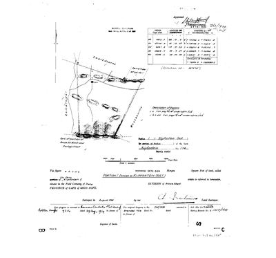 Landmeter-generaal-kaart, 285/1939, Augustus 1938
10513531.jpg
Kadaster
Die Landmeter-generaal se kaartindeks vir hierdie perseel
Die Landmeter-generaal se kaartindeks vir die hele plaas — waar die oorspronklike opmeting van hierdie grond lê.
Navorsingsnotas
[31 Jul 2026 inbox] Figure abcde, 2620.9154 morgen, called PORTION 1 (known as KLIPFONTEIN OOST), portion of the farm Klipfontein A, Field Cornetcy of Traka. Subdivisional diagram under Sect. 24(b), Act No. 9 of 1927; surveyed August 1938, diagram 285/1939 approved 21 Apr 1939; the original diagram is 284/1939 (DOC-0113). Annexed to Partition Transfer deed 9314 of 29 Aug 1939 in favour of Bernardus Lambertus SteylH. [DIAGRAM] DOC-0114. Neighbours drawn: Zwartdoorns north, Remainder of Lot No 1 north-east, Westbourne east, the Remainder west, and part of portion of Roode Els Bosch and Oorlogs Kloof south.
[13 Aug 2026] Renamed to the one form this model uses for every portion - the portion's own name, then the parent farm, its number and the portion in brackets - so that a name is legible in a list, a search result and a map popup without the reader having to know which farm number is which. It read "Klipfontein Oost (Klipfontein A Ptn 1)" before. Nothing about the ground changed.
Werknotas, hier gewys omdat dit 'n private navorsingsbou is.
Die werksnotas op hierdie werf word in Engels gehou en word nie vertaal nie. Hulle verander met elke navorsingsessie, en 'n vertaling sou uit pas raak met die oorspronklike. Alles anders — die stories, die getranskribeerde dokumente en die koppelvlak — is in Afrikaans.
Wat die rekord kortkom
-
The record stops in 1939 and never resumes
third order · B2 trail-ends
Klipfontein Oost (Klipfontein A Nr. 174 Gdlt 1) was worked as far as 1939-08-29, with Bernardus Lambertus SteylH the last owner on record. 87 years follow with nothing. Who held it after that, and is it still one farm?
What would settle it The current title deed traced backwards, each transfer names the one before it, or the Surveyor-General's subdivision diagrams, which are what usually explain a farm going quiet.
-
“Remainder of Lot No 1” is named as a neighbour 2 times and we hold no parcel for it
third order · B3 unheld-farm
2 separate surveys in this model put Remainder of Lot No 1 on the boundary of ground we do hold (PAR-000083, PAR-000084). It has no parcel of its own here, so nothing is known about who held it or when, while it borders farms at the centre of the project.
What would settle it The Surveyor-General's farm index for the registration division will give it a farm number and a diagram; the cadastre pull in `data/fetch_cadastre.py` then places it on the map.
-
“Westbourne” is named as a neighbour 2 times and we hold no parcel for it
third order · B3 unheld-farm
2 separate surveys in this model put Westbourne on the boundary of ground we do hold (PAR-000083, PAR-000084). It has no parcel of its own here, so nothing is known about who held it or when, while it borders farms at the centre of the project.
What would settle it The Surveyor-General's farm index for the registration division will give it a farm number and a diagram; the cadastre pull in `data/fetch_cadastre.py` then places it on the map.
-
“Zwartdoorns” is named as a neighbour 2 times and we hold no parcel for it
third order · B3 unheld-farm
2 separate surveys in this model put Zwartdoorns on the boundary of ground we do hold (PAR-000083, PAR-000084). It has no parcel of its own here, so nothing is known about who held it or when, while it borders farms at the centre of the project.
What would settle it The Surveyor-General's farm index for the registration division will give it a farm number and a diagram; the cadastre pull in `data/fetch_cadastre.py` then places it on the map.
Found by breaks.py reading the model against itself, not written by hand,
each one is a shape of missing record, not a fault in the data.
The whole set is on the
questions page.