Deel van Doorn Kraal Nr. 116
Lot B (Doorn Kraal Nr. 116 Gdlt 3)
· op rekord 1902 · wys op die kaart
Die plaas se eie geskiedenis — die toekenning, die oorspronklike opmeting — sit op daardie bladsy.
- Plaasnommer
- Nr. 116
- Gedeelte
- 3
- Distrik
- Prince Albert
- Grootte, soos die kaart dit stel
- 2760 morgen
Hierdie perseel het geen gepaste opmetingspoligoon nie, en kan dus nie op die kaart geteken word nie. Dit is 'n gaping in die kadasterpassing, nie 'n afwesigheid uit die rekord nie.
Waarom hierdie plaas hier is
'n Stuk van 'n plaas wat reeds in hierdie model is. Nog nie op die kaart geplaas nie.
- perseel Uitgesny uit Doorn Kraal Nr. 116
- dokument 'n Dokument in die versameling beskryf hierdie grond DOC-0250
Wat die rekord hou, in volgorde
-
Desember 1902
document
SG diagram 2103/1903
Transfer Deed No. 1592 of 11.3.1913
Begrens deur, soos die kaart hulle noem
- N Remainder of Doornkraal
- NE middle of the Kouka River
- S Van Aardts Fontein
- W Zout Water
Dokumente
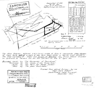 Landmeter-generaal-kaart, 2103/1903, Desember 1902
SCAN307 116 3.jpg
Navorsingsnotas
'LOT B'. Surveyed by Gerb Greeff, Government Land Surveyor, December 1902; diagram 2103/1903. GRANTED ON QUITRENT TO HENDRIK JOH VAN ECK (JOH SON) ON 15 APRIL 1841 - the same day as the five Klaarstroom basin grants this project already holds. Bounded north by the Remainder of Doornkraal, north-east by the middle of the KOUKA RIVER, south by Van Aardts Fontein, west by the place ZOUT WATER. The werf BLOEMHOF is drawn inside it, with two houses, a dam and the main road, and a note that the permanent water in the river at beacon J is common to all adjoining owners. Deducted No. 1539, 26 July 1910, by W.P. Murray. Copied 26 Aug 1949 from the diagram to Transfer Deed 1592 of 11 March 1913 in favour of Ignatius M. van EckM. THE REMAINDER of this diagram was cancelled by the Surveyor-General on 9 October 1984 in favour of a diagram for Farm 117 (CCT 48594/84).
[7 Aug 2026] NO POLYGON ON THE MODERN CADASTRE, and the diagram says why: the remainder of this portion was cancelled by the Surveyor-General on 9 October 1984 in favour of a diagram for Farm 117. The ground did not vanish; the key did.
[13 Aug 2026] Renamed to the one form this model uses for every portion - the portion's own name, then the parent farm, its number and the portion in brackets - so that a name is legible in a list, a search result and a map popup without the reader having to know which farm number is which. It read "Doorn Kraal No. 116 Portion 3 (Lot B)" before. Nothing about the ground changed.
Werknotas, hier gewys omdat dit 'n private navorsingsbou is.
Die werksnotas op hierdie werf word in Engels gehou en word nie vertaal nie. Hulle verander met elke navorsingsessie, en 'n vertaling sou uit pas raak met die oorspronklike. Alles anders — die stories, die getranskribeerde dokumente en die koppelvlak — is in Afrikaans.
Wat die rekord kortkom
-
“Van Aardts Fontein” is named as a neighbour 3 times and we hold no parcel for it
second order · B3 unheld-farm
3 separate surveys in this model put Van Aardts Fontein on the boundary of ground we do hold (PAR-000175, PAR-000176). It has no parcel of its own here, so nothing is known about who held it or when, while it borders farms at the centre of the project.
What would settle it The Surveyor-General's farm index for the registration division will give it a farm number and a diagram; the cadastre pull in `data/fetch_cadastre.py` then places it on the map.
-
“Remainder of Doorn Kraal” is named as a neighbour 2 times and we hold no parcel for it
third order · B3 unheld-farm
2 separate surveys in this model put Remainder of Doorn Kraal on the boundary of ground we do hold (PAR-000175, PAR-000176). It has no parcel of its own here, so nothing is known about who held it or when, while it borders farms at the centre of the project.
What would settle it The Surveyor-General's farm index for the registration division will give it a farm number and a diagram; the cadastre pull in `data/fetch_cadastre.py` then places it on the map.
-
“Zout Water” is named as a neighbour 2 times and we hold no parcel for it
third order · B3 unheld-farm
2 separate surveys in this model put Zout Water on the boundary of ground we do hold (PAR-000176, PAR-000182). It has no parcel of its own here, so nothing is known about who held it or when, while it borders farms at the centre of the project.
What would settle it The Surveyor-General's farm index for the registration division will give it a farm number and a diagram; the cadastre pull in `data/fetch_cadastre.py` then places it on the map.
-
Nobody is on record as ever having held this
third order · B8 never-held
Lot B (Doorn Kraal Nr. 116 Gdlt 3) is in the model, and carries no ownership record of any kind, not a grant, not a transfer, not an occupation.
What would settle it The Surveyor-General's diagram for the farm number names the grantee and the date; the deed reference on it opens the transfer chain.
Found by breaks.py reading the model against itself, not written by hand,
each one is a shape of missing record, not a fault in the data.
The whole set is on the
questions page.