Deel van Rhemhoogte Nr. 125
Groot Sleutelfontein (Rhemhoogte Nr. 125 Gdlt 2)
2/125 op die kadaster · op rekord 1883–1937 · wys op die kaart
Die plaas se eie geskiedenis — die toekenning, die oorspronklike opmeting — sit op daardie bladsy.
- Plaasnommer
- Nr. 125
- Gedeelte
- 2
- Op die kadaster
- 2/125, gedeeltegeregistreer as RHEMHOOGTE
- Distrik
- Prince Albert
- Grootte, soos die kaart dit stel
- 2108 morgen 338 sq roods
- Moderne opgemete oppervlakte
- 381.1 ha
Die historiese grootte en die moderne opgemete oppervlakte is twee aparte metings en word hier nie aangebied asof hulle mekaar bevestig nie. Die eerste is wat 'n landmeter op 'n kaart geskryf het, gewoonlik in morg. Die tweede is wat die moderne kadaster teken.
Waarom hierdie plaas hier is
'n Stuk van 'n plaas wat reeds in hierdie model is. 16 km van Klaarstroom.
- perseel Uitgesny uit Rhemhoogte Nr. 125
- perseel Uitgesny uit Rhemhoogte Nr. 125 Gdlt 1
- perseel Grond uit hierdie plaas gesny: Kareemoerhoek (Rhemhoogte Nr. 125 Gdlt 4)
- dokument 'n Dokument in die versameling beskryf hierdie grond DOC-0174
- …en nog 1, volledig gelys verder af op hierdie bladsy.
Wat die rekord hou, in volgorde
- 1883 boundary change subdivision: from Rhemhoogte Nr. 125 Gdlt 1
-
Julie 1883
document
SG diagram 1350/1883
341/1884
- Julie 1883 document SG diagram verso 1350/1883 (verso)
- 1937 boundary change subdivision: becomes Kareemoerhoek (Rhemhoogte Nr. 125 Gdlt 4)
Ook begrens deur, soos die moderne kadaster dit teken
Grond wat aan hierdie plaas raak op die Landmeter-generaal se huidige poligone en wat geen kaart wat hier gehou word, noem nie. Afgelei uit die meetkunde, nie van 'n dokument afgelees nie.
- N Groot Sluitel Fontein Nr. 126
- NE Noorsdoringkop (Groot Sluitel Fontein Nr. 126 Gdlt 1)
- E Rhemhoogte Nr. 125
- E Kareemoerhoek (Rhemhoogte Nr. 125 Gdlt 4)
- S Reim Hoogte Nr. 167
- W Bloemendal Annex Nr. 164
Dokumente
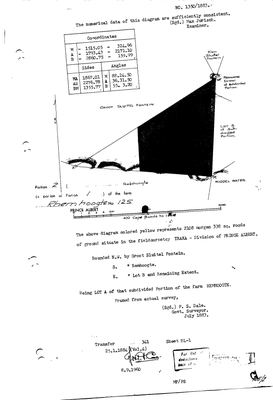 Landmeter-generaal-kaart, 1350/1883, Julie 1883
10TSWK01 125 port 2.jpg
10TSWN01.jpg
Kadaster
Die Landmeter-generaal se kaartindeks vir hierdie perseel
Die Landmeter-generaal se kaartindeks vir die hele plaas — waar die oorspronklike opmeting van hierdie grond lê.
Navorsingsnotas
[3 Aug 2026, SRC-208] Cut out of Portion 1 (PAR-000139) in July 1883 and transferred on deed 341 of 25 January 1884 to J.P. Oosthuizen - the transfer PAR-000070 cites as its own antecedent. Surveyed by P. S. Dale. Its eastern neighbour is "Lot B", which is the ground that later becomes Kareemoerhoek (PAR-000070, Portion 4). [5 Aug 2026] THE EXTENT GAP IS EXPLAINED. This row's recorded extent of about 2,108 morgen stood against a modern polygon of 381 ha - 4.7 times over, and the largest unexplained discrepancy in the model. Portion 2's own deduction table (DOC-0243) carries one line: diagram 4241/1937, KAREEMOERHOEK, 1654,0080 morgen, deed 13528/1937. Take that off and 454 morgen remain, about 389 ha, which is the polygon to within 2%. The ground became Portion 4 (PAR-000070).
[13 Aug 2026, SRC-436] NAMED FROM THE 2023 VALUATION ROLL, which gives this portion as "Groot Sleutelfontein" (389.3411 ha). This row previously read "Lot A (Rhemhoogte No. 125 Ptn 2)", which was a farm-and-portion label rather than a name. The roll is a rates document and good evidence for what the ground is called now; it says nothing about what it was called when the portion was cut. AND THE ROLL CONFIRMS THE 5 AUG DEDUCTION-TABLE READING RATHER THAN CONTRADICTING IT. This row's 1883 extent is 1805.6 ha; the roll gives Kareemoershoek (portion 4) as 1416.7 ha, which is the 1654.0080 morgen the deduction table says was cut off this portion in 1937 to within a hectare; and 1805.6 minus 1416.7 is 388.9 against the roll's 389.3 ha for portion 2. So the two extents are not in conflict at all: ours is the portion as first cut, the roll's is what is left of it, and the difference is Kareemoerhoek.
Werknotas, hier gewys omdat dit 'n private navorsingsbou is.
Die werksnotas op hierdie werf word in Engels gehou en word nie vertaal nie. Hulle verander met elke navorsingsessie, en 'n vertaling sou uit pas raak met die oorspronklike. Alles anders — die stories, die getranskribeerde dokumente en die koppelvlak — is in Afrikaans.
Oop vrae
-
Six parcels whose surveyed extent is far from their polygon with no reason recorded
prioriteit 2 · LEAD-0093
For each, is the extent mistyped, or did ground leave the farm without a note?
Wat dit sou uitmaak The deduction table. It lists portion, name, extent, diagram and deed on one line.
-
Nine diagram sheets named in the model that no longer exist on disk
prioriteit 2 · LEAD-0095
Re-pull nine Surveyor-General sheets whose archive references this model records but whose images were never kept. What do their versos carry?
Wat dit sou uitmaak Re-pulling the nine files. Each then gets its OWN DOC- row per 8, never a second filename on an existing row.
Wat die rekord kortkom
-
Nobody is on record as ever having held this
third order · B8 never-held
Groot Sleutelfontein (Rhemhoogte Nr. 125 Gdlt 2) is in the model and drawn on the map, and carries no ownership record of any kind, not a grant, not a transfer, not an occupation.
What would settle it The Surveyor-General's diagram for the farm number names the grantee and the date; the deed reference on it opens the transfer chain.
Found by breaks.py reading the model against itself, not written by hand,
each one is a shape of missing record, not a fault in the data.
The whole set is on the
questions page.