Klein Sleutlefontein Nr. 127
127 op die kadaster · op rekord 1833–1937 · wys op die kaart
- Plaasnommer
- Nr. 127
- Op die kadaster
- 127, heel plaasgeregistreer as KLEIN SLEUTLEFONTEIN
- Distrik
- Prince Albert
- Grootte, soos die kaart dit stel
- 16916 morgen
- Moderne opgemete oppervlakte
- 14391.6 ha
Die historiese grootte en die moderne opgemete oppervlakte is twee aparte metings en word hier nie aangebied asof hulle mekaar bevestig nie. Die eerste is wat 'n landmeter op 'n kaart geskryf het, gewoonlik in morg. Die tweede is wat die moderne kadaster teken.
Waarom hierdie plaas hier is
Grond waarop 'n geskrewe geskiedenis afspeel. 23 km van Klaarstroom.
- storie 'n Geskrewe geskiedenis noem hierdie grond The fifteenth of April, 1841
- storie 'n Geskrewe geskiedenis noem hierdie grond Eighty-one thousand morgen
- perseel Grond uit hierdie plaas gesny: Kleinbotterkraal (Klein Sleutlefontein Nr. 127 Gdlt 1)
- grens Deel 'n grens met Rhemhoogte Nr. 125 Rhemhoogte Nr. 125
- …en nog 2, volledig gelys verder af op hierdie bladsy.
Stories
- mentions this farm
Die vyftiende April 1841
Een landmeter meet die Koup twee seisoene lank op. Agt jaar later, op een dag, maak die Kroon 'n dosyn leningsplase titelgrond - en die distrik se kaart lê vir 'n eeu vas.
- mentions this farm
Een-en-tagtig duisend morg
Frederik Simon 'Oom Frikkie' Oosthuizen sterf in 1936 met, volgens een weergawe, 81 000 morg om Zwartkraal, omtrent 'n kwart van al die grond op hierdie kaart. Hierdie projek besit nie een akte op sy naam nie. Waarin die geld waarskynlik gesit het, waarin dit beslis nie gesit het nie, en watter een dokument die saak sou uitmaak.
Wat die rekord hou, in volgorde
-
September 1833
document
SG diagram B.326/1833
Bf.W.Q.6-5
- September 1833 document SG diagram verso B.326/1833 (verso)
-
15 April 1841
ownership
owner not named in the record
Perpetual Quitrent · grant · confidence medium
- Februarie 1937 boundary change subdivision: becomes Kleinbotterkraal (Klein Sleutlefontein Nr. 127 Gdlt 1)
Grond uit hierdie plaas gesny
- Kleinbotterkraal (Klein Sleutlefontein Nr. 127 Gdlt 1) 1/127 · 7186.0 ha
Begrens deur, soos die kaart hulle noem
- N Government ground
- S Groote Sleutle fontein
- E Reim Hoogte
- W Tygerberg
Ook begrens deur, soos die moderne kadaster dit teken
Grond wat aan hierdie plaas raak op die Landmeter-generaal se huidige poligone en wat geen kaart wat hier gehou word, noem nie. Afgelei uit die meetkunde, nie van 'n dokument afgelees nie.
- NE Kleinbotterkraal (Klein Sleutlefontein Nr. 127 Gdlt 1)
- NE Modderdrift Nr. 106
- NE Plaas 236
- E Noorsdoringkop (Groot Sluitel Fontein Nr. 126 Gdlt 1)
- E Trakasdrif (Modderdrift Nr. 106 Restant)
- E Swartskraal (Rhemhoogte Nr. 125 Gdlt 5)
- SE Kareemoerhoek (Rhemhoogte Nr. 125 Gdlt 4)
- S Bloemendal Annex Nr. 164
- S Tabaklande (Bloemendal Annex Nr. 164 Gdlt 2)
- SW Kraai Fontein Nr. 221
- SW Luiperdkop Nr. 240
- W Sand River Nr. 129
- W Sand River Nr. 130
- NW Groot Tyger Berg Nr. 102
Dokumente
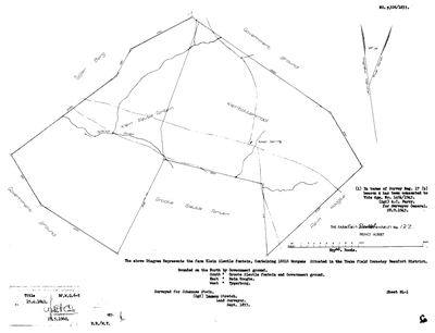 Landmeter-generaal-kaart, B.326/1833, September 1833
SCAN342.jpg
 Kaart se keersy, B.326/1833 (verso), September 1833
SCAN343.jpg
Kadaster
Die Landmeter-generaal se kaartindeks vir hierdie perseel
Navorsingsnotas
[30 Jul 2026 inbox] 'The farm Klein Sleutle fontein, Containing 16916 Morgens, Situated in the Traka field Cornetcy Beaufort District.' Bounded N by Government ground, S by Groote Sleutle fontein and Government ground, E by Reim Hoogte, W by Tygerberg. Surveyed for Johannes Stein by Lennox Stretch, Sept 1833; titled 15 Apr 1841, deed Bf.W.Q.6-5. Beacon A later consented to dgm 1404/1943 under Survey Reg. 17(b), signed A.C. Parry for the Surveyor-General 28 Sep 1943. [DIAGRAM] DOC-0137/DOC-0138. Internal features named on the sheet: Klein Sleutle fontein, Kleinbotterkraal, Groote Sleutle fontein, Sand River, a small spring.
[31 Jul 2026] Document ids corrected: the diagram rows for this farm were never created in July and the ids quoted here had since been reissued to unrelated TANAP inventories. Now DOC-0137, DOC-0138.
[3 Aug 2026, SRC-068/SRC-212] NAMED IN F.S. OOSTHUIZEN'S HOLDING. Judy Maguire's account of Oom Frikkie's 81 000 morgen (SRC-068, and STO-0020) lists "Groot and Klein Sleutelfontein and Zeekoegat" among the farms he held. This project recorded that as a name-only row, PAR-000098, without anyone noticing that BOTH FARMS WERE ALREADY HERE, pinned and drawn - this one at 14 398,3 ha. The 1971 Rhemhoogte diagram (SRC-212) supplies the farm numbers that join the two records. WHAT THIS IS AND IS NOT: the cameo says he held them; this row says the farm exists and where it is. There is still no deed or ownership span in this model putting him on it - which is the whole point of STO-0020. [TO VERIFY]
[4 Aug 2026, FRANS, FAMILY] TWO DISTINCT FARMS, CONFIRMED, AND THE SPELLING IS THE ONLY THING THAT EVER VARIED: "Klein and Groot sleutel fonteint had various spellings over the years. sleutel, sluitel, etc but seems it was always 2 distinct farms - at least since surveyd." That closes the question this row's own note left open and matches the cadastre independently: two farm numbers (126 and 127), two drawn polygons, and the two touch. The spellings recorded here are Sleutelfontein, Sluitel Fontein, Sleutlefontein, Sleutle fontein and Sluitelfontein - kept as they were written, per 5a, and never normalised into one. AND AN ODDITY WORTH KNOWING BEFORE ANYONE REASONS FROM THE NAMES: KLEIN SLEUTELFONTEIN IS THE FAR BIGGER FARM - 16 916 morgen / 14 398,3 ha against Groot's ~4 870 morgen / 4 199,1 ha, a ratio of about 3,4 to 1. Both figures check against their own diagrams. The likeliest reading is that groot and klein name the SPRINGS rather than the farms, which is how these names usually work, but that is a reading and not established here.
Werknotas, hier gewys omdat dit 'n private navorsingsbou is.
Die werksnotas op hierdie werf word in Engels gehou en word nie vertaal nie. Hulle verander met elke navorsingsessie, en 'n vertaling sou uit pas raak met die oorspronklike. Alles anders — die stories, die getranskribeerde dokumente en die koppelvlak — is in Afrikaans.
Oop vrae
-
Who actually received Klein Sleutlefontein No. 127 in 1841?
prioriteit 2 · LEAD-0090
Read Bf.W.Q. 6-5. Is the grantee Johannes Stein, J. Steyn, or someone else?
Wat dit sou uitmaak The deed. It names the grantee.
Wat die rekord kortkom
-
The record stops in 1841 and never resumes
second order · B2 trail-ends
Klein Sleutlefontein Nr. 127 was worked as far as 1841-04-15, with an unnamed holder the last owner on record. 185 years follow with nothing. Who held it after that, and is it still one farm?
What would settle it The current title deed traced backwards, each transfer names the one before it, or the Surveyor-General's subdivision diagrams, which are what usually explain a farm going quiet.
-
A tenure with no one in it
second order · B7 no-owner
OWN-000065 records a grant on Klein Sleutlefontein Nr. 127 from 1841-04-15 and names no party. Either the holder was never read off the document, or the publishing rule withheld them, the page cannot tell you which, and neither can this.
What would settle it Re-read DOC-0137.
Found by breaks.py reading the model against itself, not written by hand,
each one is a shape of missing record, not a fault in the data.
The whole set is on the
questions page.